
1811 Freycinet Map of Australia

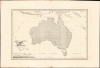
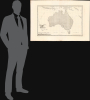
Carte Generale de la Nouvelle Hollande dressee par M L Freycinet Commandant La Goelette, Le Casuarina an 1808.
First Full Map of Australia, and the First to name Sydney.
- Digital Map Information
- Suitable for large format printing
- Full resolution TIFF file
- ICC color profile embedded
- Delivered instantly via download link
First Full Map of Australia, and the First to name Sydney.
This landmark 1811 map of Australia by French explorer and cartographer Louis de Freycinet is celebrated as the first published map to depict the continent's complete coastline and the first to identify Sydney by name. Based on surveys conducted during Nicolas Baudin's French expedition to Australia aboard the Géographe and Naturaliste (1801 - 1803), it presents the continent as Nouvelle Hollande and preserves the expedition's politically charged French nomenclature, including Terre Napoléon. Issued three years before Matthew Flinders' competing map, Freycinet's chart represents a defining achievement in the exploration, mapping and naming of Australia.A Closer Look
Coverage embraces Australia in full as well as Tasmania (Van Diémen's Land) to the south, and parts of New Guinea, Java, and the southern extreme of the East Asian archipelago; it extends east to include New Caledonia (Nouvelle-Calédonie) and the Solomon Islands (Îles Solomon). While not a nautical chart, as a nautically derived map, most of the detail is coastal, or what could be observed and measured from the coast or shipboard. While lacking soundings, some shoals and low-water areas are noted. Dashed lines within Australia attempt, to some degree, to define political zones.The Expedition
Nicolas Baudin' Expedition embarked to the South Seas in October 1800 aboard the ships Géographe and Naturaliste, arriving in May 1801. During their Australian surveys, the French team applied names to many locations already explored by Flinders (the French and English would actually meet at Encounter Bay). The expedition charted the circumference of the continent, to which they applied this historic name, 'Nouvelle Hollande.'Return and Publication
The expedition set sail for France (via Timor) in 1803. Baudin died on the voyage, leaving the publication of the voyage to the expedition's naturalist, Francois Péron. Péron produced the first volume of Voyage de Découvertes aux Terres Australes in 1807, but died in 1810 before completion of the account. Freycinet took over the labor, issuing the second volume and its atlas. It was this volume that contained the charts of the expedition.The Competition, Nobbled
The English explorer, Matthew Flinders, completed his circumnavigation of Australia before the French; nonetheless, his map was not the first to illustrate a full circumnavigation of the continent. Flinders began his return to England in 1803, shortly after the French, but en route, he was arrested by the French governor of Mauritius (despite the scientific nature of the voyage, France and England were at war), where he was detained for more than six years. Although Flinders was eventually released and returned to England in 1810, his work was not published until June of 1814 - a day before his death, and three years after Freycinet's publications.Terre Napoléon and other French Toponymy
Where the map depicts regions discovered by the Dutch in the 17th century, Freycinet applies broad regional names. Tasmania, for instance, remains Terre de Diémen (van Diémen's Land); Terre de Nuyts, Terre der Leuwin, Terre d'Endracht, Terre de Witt, Terre d'Arnheim, and Terre de Carpentiere all reflect Dutch navigation, as does the whole landmass, Nouvelle Hollande.The newly surveyed southern and eastern coasts are a different matter. The authors have here claimed the south coast as a French discovery, naming it Terre Napoléon, despite Flinders having charted the area first. Flinders' 'Spencer Gulf' and 'Gulf St. Vincent' are here named after Napoléon and Josephine. Despite Baudin's genial communications with Flinders during their overlapping voyages, Freycinet largely ignores the English efforts to chart the southern coast, using none of the English toponymy in favor of the French, likely out of patriotism and loyalty. Even in the areas initially charted by the Dutch, but where Baudin charted the coasts in finer detail, Francophone toponymic conventions are applied.
Elegant Engraving
In addition to the chart's fine, clear lettering (courtesy of hte elusive letter-engravers Lale and Girladon) and delicate shading, it sports an excellent, evocative cartouche: an eagle in flight bears a trident and a banner with the map's title, over a scene depicting ships sailing along a mountainous coast, with sea birds diving for fish in the foreground and a school of dolphins in the middle distance. The whole evokes the region's geographical richness and biological exoticism.Publication History and Census
This map is rare on the market. It was published in the atlas accompanying the second volume of Voyage de Découvertes aux Terres Australes. The separate map is cataloged only 8 times in OCLC.Cartographers
Louis Claude de Saulces de Freycinet (August 8, 1779 - August 18, 1841) was a French Navy officer and circumnavigator. In 1811, he published the first map to show a full outline of Australia's coastline. Louis-Claude de Saulces de Freycinet joined the French Navy as a midshipman in 1793, and took part in several engagements against the British during the French Revolution (1789 - 1799). In 1800, Freycinet and his brother Louis-Henri were attached to an expedition to Australia under Nicolas Baudin (1754 - 1803), on the ships Naturaliste and Géographe. Between 1802 and 1803, Freycinet captained the schooner Casuarina, executing surveys of the Australian coast. He returned to France in 1804. Back in Paris, he prepared the maps and plans of the expedition, as well as the accompanying narrative, Voyage de découvertes aux terres australes (Paris, 1807-1816). Later, in 1817, he was given command of the corvette Uranie, which he led on scientific expeditions to Rio de Janeiro and, later, throughout the Pacific - a successful voyage, despite the loss of his ship on his return. Freycinet was admitted into the French Academy of Sciences in 1825 and was one of the founders of the Paris Geographical Society. Further Details...
Pierre Antoine-François Tardieu (February 17, 1757 - January 14, 1822), also known as Tardieu de l'Estrapade, for his address at Place de L'Estrapade, was a French geographical engraver and publisher active in Paris during the late 18th and early 19th centuries. A member of the large and prolific Tardieu family, which, for over 200 years, produced multiple skilled and active engravers. A disciple of his uncle Pierre-François Tardieu, in his youth Antoine-Francois would sign his works Pierre-François (or P.F. Tardieu; 1711 - 1771) , but later in his career began using his own name or (P.A.F. Tardieu). His two sons, Pierre-Antoine Tardieu and Ambroise Tardieu (1788 - 1841), both became noted geographical engravers in the own right. Further Details...
Nicolas Thomas Baudin (February 17, 1754 - September 16, 1803) was a French naval officer, cartographer, naturalist, and explorer whose voyages made major contributions to the scientific study and mapping of Australia and the wider Indo-Pacific. Born on the Île de Ré into a merchant family, he went to sea at a young age, served in the merchant marine, joined the French Royal Navy as a cadet in 1774, and fought during the American Revolutionary War (1775 - 1783). However, his non-aristocratic origins limited his advancement in the officer corps. After returning to commercial service, he developed expertise in transporting living plants and animals. He commanded natural-history expeditions to the Indian Ocean and Caribbean, including voyages associated with the Austrian imperial gardens at Schönbrunn and, from 1796 to 1798, the French Muséum National d'Histoire Naturelle; these expeditions returned valuable collections of plants, birds, insects, and other specimens. Reinstated in the French Navy as a captain, Baudin secured Napoleon Bonaparte's approval to lead an ambitious scientific expedition to the southern lands aboard the corvettes Géographe and Naturaliste, which departed Le Havre in October 1800 with an unusually large company of naturalists, artists, hydrographers, and gardeners. Between 1801 and 1803, the expedition surveyed extensive portions of the western, northern, southern, and southeastern Australian coasts, visited Timor and Tasmania, documented indigenous peoples, and gathered tens of thousands of zoological and botanical specimens, many previously unknown to European science. In April 1802, Baudin encountered the British navigator Matthew Flinders at South Australia's Encounter Bay; despite their countries' political rivalry, the two commanders exchanged information peacefully. Baudin's leadership was hampered by illness, deaths, desertions, and inadequate supplies, as well as bitter disputes with several officers and scientists, particularly François Péron. Suffering from tuberculosis, Baudin died at Île de France, now Mauritius, on September 16, 1803, before the expedition returned to France. Its published narrative, prepared by Péron and later completed by Louis de Freycinet (1799 - 1841), largely omitted or disparaged its deceased commander, obscuring his achievements for generations. Modern scholarship has restored Baudin's reputation, recognizing that his expedition produced some of the earliest detailed charts of large stretches of Australia, assembled one of the richest natural-history collections of its age, and left an exceptional visual and written record of Australian landscapes, wildlife, and indigenous communities. Further Details...
Source
Freycinet, Louis de, Voyage de découvertes aux terres australes. / Atlas. Deuxième partie, (Paris: Langois) 1811.
Condition
Excellent. Including margins, measures 27.75 x 41.25 in.
References
OCLC 223110568. Clancy, R. Terra Australis, pp. 137, 140. Tooley (Australia) #610, p. 82.