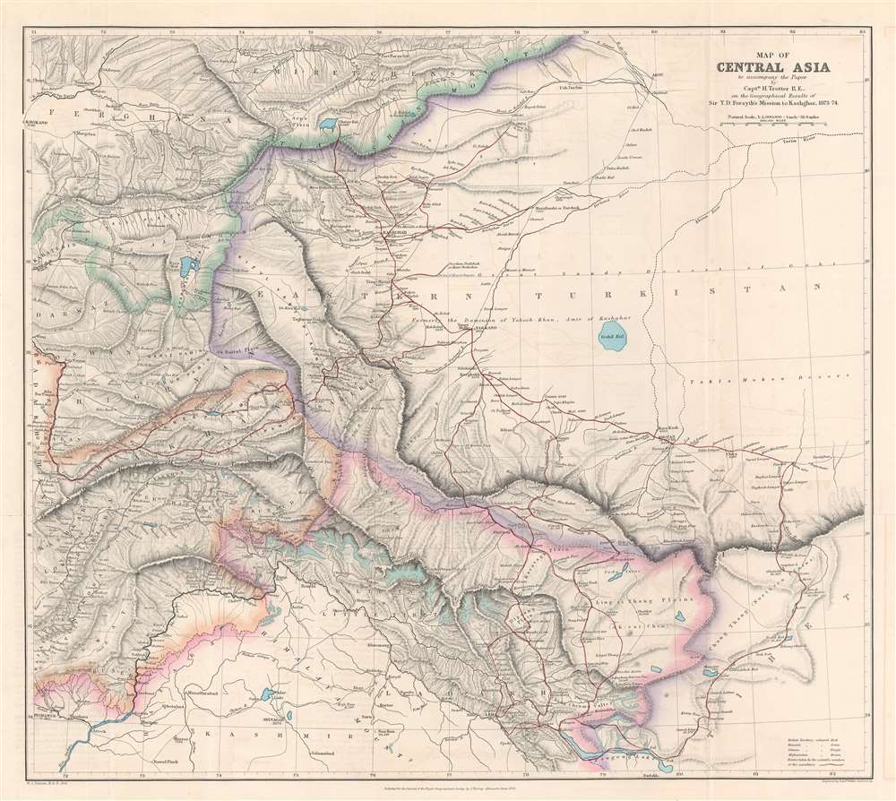
1878 Turner Map of Xinjiang China during the Dungan Revolt
CentralAsia-turner-1878-2$1,350.00

Title
Map of Central Asia to accompany the Paper by Captain H. Trotter R.E., on the Geographical Results of Sir T.D. Forsyth's Mission to Kashgar, 1873 - 74.
1878 (dated) 18.75 x 20.75 in (47.625 x 52.705 cm) 1 : 2000000
1878 (dated) 18.75 x 20.75 in (47.625 x 52.705 cm) 1 : 2000000
Description
This is an 1878 William John Turner and Royal Geographical Society map of Xinjiang, China that traces explorations of the Forsyth Mission of 1873 - 1874, making this one of the first detailed Western maps of the region. The map depicts the region from Peshawar, Pakistan to Tibet and from the Tian Shan Mountains to Pangong Lake. British, Russian, Chinese, and Afghan territory are color coded with a key in the lower right. The routes of the Forsyth Mission are traced in red. Three different groups set out from Leh, India, to reconvene at Yarkand, in the 'Dominion of Yakoob Khan', and proceeded to Kashgar, where they met Yakub Beg.
The Forsyth Mission
In 1870, T. Douglas Forsyth led an unsuccessful mission into this part of the world from India to meet Yakub Beg, the leader of the Dungan Revolt against the rule of Qing Dynasty, in order to secure a trade agreement between Beg and British India. By the time Forsyth reached his destination, Beg, known as the 'Atalik Ghazi', was six hundred miles away. Forsyth's subsequent 1873 mission proved successful, and, after gaining the blessing of the 'Atalik Ghazi', Forsyth and his team were able to use their scientific equipment to accurately map their expedition. The 1873 mission officially had the same objective as his previous, to secure a trade agreement with Beg, with the hope of preventing him from trading with Russia. Russia and Britain were then locked in a rivalry over Central Asia that has become known as 'The Great Game'.The Great Game
From 1830 until 1895, a political and diplomatic confrontation, known as 'The Great Game', pitted the British Empire against the Russian Empire over Afghanistan and other territories in Central and Southern Asia, making this a flashpoint region during an era steeped in distrust and the constant threat of war. 'The Great Game', as it is known, was ignited due to Russian fears that Britain would make commercial and military inroads in Central Asia, while Britain mutually feared Russia adding 'the jewel in the crown' (India) to its empire in Asia. Several wars were fought, including the First Anglo-Afghan War in 1838, the First Anglo-Sikh War in 1845, the Second Anglo-Sikh War in 1848, and the Second Anglo-Afghan War in 1878, along with the Russian annexations of Khiva, Bukhara, and Kokand. Per historians, the Great Game ended on September 10, 1895 with the signing of the Pamir Boundary Commission protocols, which defined the border between Afghanistan and the Russian Empire.Publication History and Census
This map was created by William John Turner, engraved by Edward Weller, and published in Volume 48 of The Journal of the Royal Geographical Society. The OCLC records an example in the collection of the British Library and we are also aware of an example in the collection of the University of Texas at Austin.CartographerS
William John Turner (fl. c. 1876 - 1892) was an English cartographer and geographer who operated in London during the late 19th century. Turner was officially employed by the Royal Geographical Society as a cartographer beginning on November 15, 1873 and accepted the post of 'Map Draughtsman and Assistant Curator' on June 29, 1877. Also in 1877, Turner began advocating for the 'in-house' creation of all maps published in the 'Journal of the Royal Geographical Society'. In May 1878, acting on his advice, Turner was given the post of 'Chief Draughtsman' for in-house cartography. Turner left the Royal Geographical Society in 1881 to work for A.K. Johnston. Turner left the Johnston firm in December 1886, and, after a time, was employed by the Royal Geographical Society from May 1887 until May 1889 'construction wall maps etc.' and 'contoured maps'. Later he partnered with W. Shaweto found 'Turner and Shawe', lithographers working for the RGS. The 'Turner and Shawe' imprint was active until at least 1904. More by this mapmaker...
Edward Weller (July 1, 1819 - 1884) was a cartographer and engraver based in London. Weller was a nephew of another well-known map publisher Sidney Hall (1788 - 1831), who gave him 50 Pounds to pay his apprenticeship fees. He engraved for many prominent mapmakers and was active enough in the community to be recommended for membership to the Royal Geographical Society in 1851 on the recommendation of John Arrowsmith, among others. He eventually inherited the Sidney Hall map business which led him to follow Arrowsmith as the unofficial geographer to the Royal Geographical Society. Weller was among the first map printers in London to embrace lithography. His best known work appears in Cassell's Weekly Dispatch Atlas, published in monthly segments for subscribers of the 'Weekly Dispatch' newspaper. This collection of maps eventually grew to include much of the known world. Published in various editions from 1855 through the early 1880s. Weller died in May of 1884, leaving behind a successful business and an unhappy widow. His son, Francis Sidney Weller (1849 - 1910), followed in his father's footsteps and continued the family map business. The atlas Mackenzie's Comprehensive Gazetteer of England and Wales was published in 1894 and bore F. S. Weller's signature on the maps. Learn More...
John Murray I (1737 - 1793) founded the British publishing firm John Murray (1768 - present) in London. Born in Edinburgh, Murray served as an officer in the Royal Marines and built a list of authors that included Isaac D’Israeli and published the English Review. Murray the elder also was one of the founding sponsors of the London evening newspaper The Star in 1788. John Murray II (November 27 1778 - June 27, 1843) continued the family publishing business and developed it into one of the most important and influential publishing houses in Britain. The list of authors published by the firm grew to include Jane Austen, Sir Walter Scott, Washington Irving, George Crabbe, and Lord Byron under his tenure. Murray II also moved the business to 50 Albermarle Street in Mayfair, which became famous for Murray’s tradition of ‘four o’clock friends’, which was afternoon tea with his writers. John Murray III (1808 - 1892) continued to grow the business, and the firm published the first English translation of Goethe’s Theory of Colours, David Livingstone’s Missionary Travels and Charles Darwin’s Origin of Species during his tenure. Murray also published Herman Melville’s first two books. The firm began publishing Murray Handbooks in 1836, an ancestor of all modern travel guides. Sir John Murray IV (1851 - 1928) was publisher to Queen Victoria. Three successive Murray’s after Murray IV led the business until it was purchased by Hodder Headline in 2002, which was acquired by the French conglomerate Lagardère Group in 2004. Today, Murray is an imprint of Lagardère under the imprint Hachette UK. Learn More...
Royal Geographical Society (fl. 1830 - present) is a British Society established in 1830 to promote geographical science and exploration. Originally titled the "Geographical Society of London", the RGS received its royal charter from Queen Victoria in 1859 shortly after absorbing several similar but more regional societies including the African Association, the Raleigh Club and the Palestine Association. The RGS sponsored many of the most important and exciting voyages of exploration ever undertaken, including the exploration of Charles Darwin, David Livingstone, Robert Falcon Scott, Richard F. Burton, John Speke, George Hayward, H. M Stanley, Ernest Shackleton and Sir Edmond Hillary. Today, the RGS remains a leading global sponsor of geographical and scientific studies. The Society is based in Lowther Lodge, South Kensington, London. Learn More...
Source
Trotter, H., 'On the Geographical Results of the Mission in Kashgar under Sir T. Douglas Forsyth in 1873 - 74'., The Journal of the Royal Geographical Society Vol. 48, (London: John Murray) 1878.
Condition
Very good. Exhibits light wear along original fold lines. Verso repair to a fold separation. Accompanied by original journal article.
References
OCLC 556424213. Harvard University Bulletin, Volumes 4-5, 'Classified Index to the Maps Contained in the Publications of the Royal Geographical Society', #200.