
1763 Set of 4 Desnos Continents: Unrecorded First states, first plates

This item has been sold.
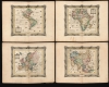
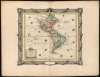
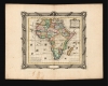
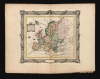
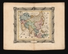
L'Amerique Dresseé pour l'etude de la Géographie... / L'Afrique Dresseé pour l'etude de la Géographie... / L'Europe Dresseé pour l'etude de la Géographie... / l'Asie Dresseé pour l'etude de la Géographie...
Matched set - all unrecorded examples in their earliest printings.
- Digital Map Information
- Suitable for large format printing
- Full resolution TIFF file
- ICC color profile embedded
- Delivered instantly via download link
Matched set - all unrecorded examples in their earliest printings.
This is an extremely rare, unrecorded, matched set, with original hand color, of the 1763 first state, first plate printings of Desnos' maps of the continents. They appeared in Pierre Mathias de Gourné's Atlas abrégé et portatif, printed in 1763 in a single edition. The publisher (Desnos) would replace all of these plates during the course of 1764: so while those copies would continue to be employed in subsequent Desnos productions, the maps would appear in this form only in the 1763 Gourné Atlas. The atlas itself is a great rarity - there are two institutional examples cataloged - and these 1763 states have not to date been recorded.Puzzling Attributions
Desnos credits, on three of these four maps, the 1753 geography of Sr. Janvier. Even taking into account possible revisions by Desnos, this represents a puzzle, in that no maps of that year, of these regions, by Jean Denis Janvier have come down to us. Furthermore, the maps attributed to Janvier that do cover these regions do not resemble these: a much more credible source for all four of these maps is the maps printed by Georges-Louis Le Rouge, which were first printed in 1747 and would continue in print with revisions throughout the 18th century.All four maps are embellished with an identical decorative border: this was printed using a separate copperplate from that which was used for each map. The border was engraved by Le Charpentier and dated 1763. Each map is embellished with an elegant, rectangular title cartouche, garlanded and surmounted with a crown and the French Fleurs de lis.
A Closer Look: The Western Hemisphere
This attractively rendered map of North and South America presents the American continent from Tierra del Fuego to Hudson's Bay; the map includes islands of both the Atlantic and the Pacific; both oceans are decorated with sixteen sailing ships. The American northwest is presented with extremely convenient waterways spanning the continent via the Great Lakes. In the south, some early colonial cities such as Cuzco, Lima, and La Paz are noted. The Orinoco, Amazon, and La Plata river systems penetrate deeply into the continent, but exhibit none of the vast network of tributaries for which they are best known. The Rio de La Plata terminates at the Lac Xarayes, a mythical lake often associated with legends of the Earthly Paradise and El Dorado, but in fact is simply a misinterpretation of the Pantanal during its annual inundation.Attributions
Desnos' map credits a 1753 map by Janvier as its source; this is spurious. We see no Janvier map sharing any of the salient features of this map - most particularly, the depictions of the Pacific islands and the northwest part of Canada resemble no map associated with Janvier that we can find. On the other hand, the map bears a strong resemblance to the 1753 second state of Georges-Louis Le Rouge's L'Amerique/ suivant/ Le R.P. Charlevoix J.te/ Mr. De La Condamine/ et Plusieurs autres, particularly with respect to the very distinctive lake pattern in Canada. The lake appears first in a 1743 Bellin, and it is from here that it came to Le Rouge, but the notation here with respect to the conjectural Mer de l'Ouest cannot have been derived from any source earlier than 1753. The similarity between the present map and the Le Rouge extends to phrasing elsewhere, such as that used for the Pacific discoveries of Quiros and David, and so Desnos' source in the Le Rouge seems clear.This first, 1763 issue of the map is unique in its inclusion of Janvier's name in the cartouche (which is, itself, unique to this issue of the map). The Le Charpentier-engraved border, with its date of 1763, features an empty cartouche oval at bottom center. In 1764, the map plate was reworked to include a new cartouche, this time lacking Janvier's imprint; the same border was employed, but by this time, the cartouche oval included Desnos' titles, address, and the date 1764. Later that same year, the plate would be entirely replaced (most easily identified by its inclusion of Greenland, but there are multiple small differences in toponymy and the engraving of the ships). The map would continue to be published in Brion de la Tour's Atlas Général, Civil Et Ecclésiastique beginning in 1766, now featuring a new border without a cartouche oval. Later still in the map's long publication history, it would appear with and without decorative borders, sometimes with printed text to each side, sometimes with the text pasted down; these editions continued as late as 1798.
Africa
Desnos' map of Africa, again, includes reference to a 1753 map of Janvier; again, this attribution is spurious. No 1753 Janvier map of Africa comes down to us, and his 1760 map of Africa is a copy of D'Anville's map of the continent. The present 1763 map is again clearly derived from the 1747 Le Rouge map, and just as the Le Rouge America relied on illustrious sources - Condamine and Charlevoix - so the Le Rouge map of Africa was derived from the groundbreaking 1737 map of Matthias Hass. This map follows Le Rouge and Hass in dispensing entirely with the Ptolemaic depiction of the headwaters of the Nile at the Mountains of the Moon, instead including the text notation that 'the whole interior of this country is entirely unknown.' In Abyssinia, the source of the Nile is shown at Lake Tana. The second plate of this map, in addition to the new cartouche and Brion de la Tour's imprint, would reinstate the Ptolemaic lakes in imitation of D'Anville. The map is beautifully embellished; seven sailing ships prowl the waters of the 'sea of Africa' and the Indian Ocean.The map appears to have shared a similar publication history to that exhibited with the America map: we see examples with similar variations in decorative borders and text.
Europe
Like the previous maps, Desnos credits a spurious 1753 Janvier map; like the previous maps, Desnos has copied a 1747 Le Rouge map: L'Europe, suivant les nouvelles observations de M. de Cassini et de M. Hass. Maps of continental Europe have been neglected in cartobibliographies, and so the print history of this map is not as well documented as the other continents; those examples we have found pictured in dealers' catalogs and online offerings suggest a similar publication history to the others, with only this 1763 edition exhibiting the rectilinear cartouche to the left, and the empty cartouche oval in the dated 1763 border.Asia
While sharing the decorative characteristics of the other maps of this group, this map of Asia is unique in lacking the spurious Janvier imprint. It is in all other respects sister to the other three, including its derivation from the 1747 Le Rouge map, L'Asie Suivant les Dernres Observons. des Moscovites. In addition, it includes a putative coastline in the North Pacific 'Terre vue par Mr.s Tchiricow et Delisle en 1741', which did not appear on Le Rouge's Asia, but did appear on the second state of his map of America (referred to above) and his world map. It may have been an embryonic representation of the Muller Peninsula.In addition to its inclusion of Tschirikow's Pacific geography, Desnos's map depicts the apocryphal Terre de la Ieso, and the Terre de Compagnie or Terre de Gama. To the south of these, the sea between Japan and Korea is termed the Sea of Korea (Mer de Coree). This tends to follow the naming conventions of the St. Petersburg Academy of Sciences, which referred to the body of water as 'Koreiskoe Mope' or 'Sea of Korea' in their 1745 map of Asia.
Publication History and Census
This set of maps is extremely rare. They were engraved for Pierre Mathias de Gourné's Atlas abrégé et portatif, printed by Desnos in 1763. The plates would be replaced with new ones for Brion De la Tour's atlases produced with Desnos. We are aware of only one further 1764 printing of this plate of the America map, and while it is conjecturally sound to suppose the other maps in the set to have been similarly reprinted, we have no concrete evidence of any further printing from these plates. We have seen no separate examples of these 1763 first state, first plate printings either on the market or in institutional collections. We see only two examples of Gournet's 1763 atlas in institutional collections: one held by the Bibliothèque National de France, and the other by the Bibliothèque Geneve.Cartographer
Louis Charles Desnos (1725 - April 18, 1805) was an important 18th century instrument maker, cartographer and globe maker based in Paris, France. Desnos was born in Pont-Sainte-Maxence, Oise, France, the son of a cloth merchant. From April of 1745 he apprenticed at a metal foundry. Desnos married the widow of Nicolas Hardy, sone of the map, globe, and instrument seller Jacques Hardy. Desnos held the coveted position of Royal Globemaker to the King of Denmark, Christian VII, for which he received a stipend of 500 Livres annually. In return Desnos sent the King roughly 200 Livres worth of maps, books and atlases each year. As a publisher, Desnos produced a substantial corpus of work and is often associated with Zannoni and Louis Brion de la Tour (1756-1823). Despite or perhaps because of the sheer quantity of maps Desnos published he acquired a poor reputation among serious cartographic experts, who considered him undiscerning and unscrupulous regarding what he would and would not publish. Desnos consequently had a long history of legal battles with other Parisian cartographers and publishers of the period. It is said that he published everything set before him without regard to accuracy, veracity, or copyright law. Desnos maintained offices on Rue St. Jacques, Paris. Further Details...
Source
Gourné, Pierre-Mathias de, Atlas abrégé et portatif..., (Paris: Desnos) 1763.
Condition
Very good. Some unobtrusive spots and minor stains; printer's crease to Europe map entering at bottom, separation along crease in margin only. Else excellent with bold strikes and generous borders, with original outline and wash color. Listed size identical for all four maps.
References
OCLC numbers: Atlas, OCLC 494751567. America OCLC 1057341230. cf. McGuirk, D., The Last Great Cartographic Myth: Mer de l’Ouest, #130 (1764-98; this 1763 issue not here recorded.) Africa: OCLC 631836907 (1766). Norwich, O., Maps of Africa, #97 (1766) Europe: OCLC 300011855 (1766). Asia: OCLC 48451253 (1765).