
1938 Harbold Pictorial Map of the World and its Pirates


This item has been sold.
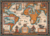
The Map of Famous Pirates Buccaneers and Freebooters who roamed the seas during the seventeenth and eighteenth centuries.
...those lusty days when bold buccaneers roamed the seven seas. - Harbold
- Digital Map Information
- Suitable for large format printing
- File Size: 36.8 MB
- File Type: ZIP / TIFF
- ICC color profile embedded
- Delivered instantly via download link
...those lusty days when bold buccaneers roamed the seven seas. - Harbold
This is a 1938 Darby Harbold pictorial map of the world celebrating all things piratical. The map romanticizes the Golden Age of Piracy and its legends: Edward 'Blackbeard' Teach, Jean Lafitte, Henry Morgan, Anne Bonny, Captain Kidd, and Samuel Burgess, among others.A Closer Look
The map is a fascinating combination of history, legends, and popular pirate lore. Sites associated with the most famous pirates, as well as illustrations of their ships, pepper the map. Banners mark the sites of discovered or suspected pirate treasure. Insets detail New England, where the West Indies pirates, including Blackbeard and Stede Bonnet, cruised in the summer months, and the British Isles, where many of the most famous pirates, including Blackbeard, Avery, Morgan, and Kidd hailed. A third very large inset focuses on the West Indies, where the most successful pirates thrived on sacking Spanish forts and treasure galleons. Throughout, vignettes and annotations illustrate pirate lore, lifestyle, and odd facts.The Geography of Piracy
The map states that Madagascar and New York were the best markets for the pirates' ill-gotten gains. An inset off the coast of New England focuses on the region and emphasizes the pirates' affinity for cruising there in the summer. However, Boston proved 'unpopular with pirates' because they 'disliked her gallows.' This point is reinforced in the inset by the small icon of a gallows in Boston. Specific islands were favored by specific pirates, while others were plundered. An inset of the West Indies in the lower-left corner details pirate activities in the Caribbean. This area included the fabled Spanish Main, where treasure galleons carrying gold and other minerals mined in the New World set sail for the mother country. These fortunes were too good for many pirates to overlook, and thus a deadly game of cat and mouse ensued.Romanticization of Piracy
In the 1930s, the romanticization of the Golden Age of Piracy flourished in popular culture as books, films, and radio dramas transformed pirates from ruthless criminals into charismatic, freedom-loving adventurers. This revival was partly an escapist response to the Great Depression, offering audiences rebellion, exoticism, and independence in contrast to the harsh reality of widespread economic hardship and social constraint. Hollywood played a decisive role: films such as Captain Blood (1935) starring Errol Flynn and Treasure Island (1934) from Robert Louis Stevenson's classic novel established enduring tropes - dashing heroes, buried treasure, parrots, and 'X marks the spot.' Publishers and pulp magazines likewise glorified piracy through illustrated adventure stories filled with romantic seafaring imagery. The era also saw a growing fascination with Caribbean locales and nautical nostalgia, reflecting both imperial mythmaking and the allure of life beyond conventional authority. By the decade's end, the pirate - once a symbol of lawlessness - had become a pop-cultural archetype of courage, freedom, and rebellion, a sanitized legend far removed from the brutal realities of historical piracy.Publication History and Census
This map was designed by Darby Harbold and published by the Lebaron-Bonney Company in 1938. Since the Lebaron-Bonney Company produced their maps as main-order products, it is likely that not many were made. We do see advertisements for the map in 1938 and 1939 issues of House Beautiful and Publisher's Weekly. We are aware of only two other known examples, which are part of the collections at the Library of Congress and the David Rumsey Map Collection at Stanford University.Cartographers
Darby Harbold (fl. c. 1930 - 1942) is an enigmatic American illustrator best known for his 1838 pictorial map of the world The Map o Famous Pirates Buccaneers and Freebooters. He is otherwise extremely elusive. It is likely that Harbold lived in Massachusetts, possibly Haverhill. Further Details...
LeBaron-Bonney Company (1938 - 2019) was a novelty publishing company based in Bradford, Massachusetts. The company was formed by the brothers Le Baron Atwood Atherton (July 31, 1905 - 19??) and John / Jack 'Bonney' Atherton (1913 - ). The Athertons were born in Brockton, Massachusetts. Their family owned the 'Atherton Furniture Company'. The LeBaron-Bonney Company was initially a bicycle rental service on Cape Cod, near the Atherton family summer home, but almost immediately changed course and began issuing direct-mail pictorial maps, model ships, and other novelties. The firm's interest in pictorial maps seems to stem from Jack Atherton, who designed and published a map of Martha's Vineyard independently in 1937. Other maps include a 'Pirate Map' of the world, and Map of Maine (1938). In 1959, the firm moved to Haverhill, MA, and changed course again and began restoring vintage Ford and GM cars. They moved again, this time to Amesbury, MA. At some point, the Athertons sold their shares to other interests. LeBaron-Bonney formally declared bankruptcy and went out of business in 2019. Further Details...
Condition
Very good.
References
Library of Congress G3201.E75 1938.H3. Rumsey 8331.000. A Descriptive List of Treasure Maps and Charts, in the Library of Congress, page 8.