
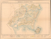
1908 Service Geographique Map of the Guangzhouwan Leased Territory, China


This item has been sold.
Kouang-Tchéou-Wan.
France's Failed Bid to Create a Rival to Hong Kong.
- Digital Map Information
- Suitable for large format printing
- Full resolution TIFF file
- ICC color profile embedded
- Delivered instantly via download link
France's Failed Bid to Create a Rival to Hong Kong.
This is a 1908 Service Geographique de l'Indochine map of the French-leased territory of Guangzhouwan in southern China - it captures a little-known chapter in Chinese colonial history. The territory, which the French hoped would rival Hong Kong, instead became a comically ineffective colonial project, and a thorn in the side of most, administered by and for Chinese gangsters.A Closer Look
The map covers the leased territory with some reference to villages just beyond its borders. The main colonial settlement, Fort Bayard, can be seen at the top, while further north are Chinese villages (Ma Tchiang, Tchia K'am, Potao) that operated as commercial centers, benefiting from smuggling across the border between the leased territory and the surrounding Guangdong. A wide range of detail is included regarding terrain (color-shaded), communications infrastructure, land use, and waterways, all explained in a legend at bottom.The Guangzhouwan Leased Territory
The Guangzhouwan (or Guangzhou Bay 廣州灣) Leased Territory was a failed French attempt to develop a trade entrepôt on the southern coast of China akin to Hong Kong. Leased from the Qing in 1898 under the pressure of gunboat diplomacy, it was France's contribution to a 'scramble for concessions' in the wake of the First Sino-Japanese War (1894 - 1895) that saw the British gain the New Territories of Hong Kong and Weihaiwei and Russia acquire concessions in Manchuria, among others. Jealous of British (and, to a lesser extent, Japanese and American) commercial interests in China and feeling ambitious after consolidating colonial rule in Tonkin and expanding French influence in Yunnan and Guangxi, France wrested a 99-year lease for a portion of the eastern coast of the Leizhou Peninsula. The concession was seemingly well-placed, near Hainan Island and close enough to Hanoi-Haiphong to be reached quickly by troops or administrators.However, the concession was plagued with problems from the start. Based on the account of a French ship that had wrecked near there some two centuries earlier, the French badly misjudged the bay's suitability for large ships, quickly scuttling hopes for a major port operation. Also, unlike Hong Kong, Macao, or Shanghai, Guangzhouwan did not sit near the mouth of a major river and trading artery (despite its deceptive name, which many in Europe easily confused with the city of Guangzhou, which is, in fact, on the Pearl River near Hong Kong, more than 200 miles to the east of the French leased territory). A related issue is that the leased territory was in a resource-poor part of China, leaving the trade entrepôt with few goods to trade, and the French with the problem of how to pay for the territory's administration and defense. Desperate administrators introduced a colonial-style 'head tax' on the local population and generated revenue through taxes on vices like prostitution, gambling, and opium. What little interest the leased territory generated in France (or Hanoi for that matter) quickly dissolved and it came to be run by local grandees turned gangsters, working in tandem with the French authorities. br>
Guangzhouwan became a major thorn in the side of the Qing and later Republican Chinese governments, who aimed to collect customs duties on opium and other products smuggled into China across the porous borders of the leased territory. The Nanjing government of Chiang Kai-shek, driven by anti-imperialist zeal and a desperate need to collect customs revenue, ringed the leased territory with dozens of customs and police stations as well as warships, but was still unable to stamp out smuggling. Conversely, the smuggling enterprise in the leased territory became a vital lifeline to Chiang's wartime government in Chongqing during the Second Sino-Japanese War / Second World War, dubbed by some the 'Chinese Casablanca,' until it was occupied by Japanese troops in 1943. After the war, the French willingly signed away Guangzhouwan and their other concessions in China in exchange for Chiang's help in reestablishing French control over northern Vietnam, which his troops occupied at the end of the war. The gangsters who were the true rulers of Guangzhouwan remained throughout, working with the French, Chinese, and even, in many cases, the Japanese, though they correctly surmised that the Communists would be less accommodating and fled to Macao or Hong Kong during the Chinese Civil War (1946 - 1949).
Publication History and Census
This map was prepared by the Service Geographique de l'Indochine, under the leadership of Col. Friquegnon and based on surveys by military officers listed in the top-left margin. It is only cataloged among the holdings of the Bibliothèque nationale de France (cataloged twice in the OCLC). The Bibliothèque interuniversitaire de la Sorbonne appears to hold an alternate printing (OCLC 927404386), part of a collection of maps of French Indochina.Cartographers
Service Géographique de l'Indochine (1899 - c. 1954) was created by decree on July 5, 1899. A Lieutenant Colonel Lubanski, from the Service Géographique de l'Armée, was put in charge. He along with several other army officers, as well as trained topographers and other geographers, immediately began applying the cutting-edge scientific practices employed by the Service Géographique de l'Armée in France to Indochina. They were tasked with creating detailed new maps of the colony. The Service Géographique immediately began mapping the Tonkin and Than-hoa deltas in extreme detail, and published annually a report on their progress. As for the rest of the country, which was sparsely populated and frequently inaccessible jungle, much less detailed maps were deemed sufficient. The Service Géographique also published an Atlas of Indochina annually from 1920 until at least 1932, as well as a summary of their work, which was published annually from 1900. Although the historical record is unclear, it is likely that the Service Géographique was disbanded during the Japanese occupation of Indochina during World War II and reconstituted after the Japanese defeat. During the 1950s the Service Géographique benefited from aerial photography. Further Details...
Jean Baptiste Laurent Friquegnon (August 10, 1858 - 1934) was a French geographer and military officer. Born in Valleroy, France, Friquegnon entered the military on March 1, 1877. He was promoted to sous-lieutenant d'Infanterie de Marine on March 19, 1883. By January 1885 he was serving in Tonkin in French Indochina as a member of the Tirailleurs tonkinois. Friquegnon was gravely wounded on an expedition to Kem that year, he was promoted to lieutenant and named a Chevalier of the Legion of Honor. In 1889 he was appointed to the service topographique de l'état-major d'Hanoï, and subsequently became a member of the Pavie expedition to Laos, led by Auguste Jean-Marie Pavie (May 31, 1847 - June 7, 1925). He was one of Pavie's photographers on this expedition and took numerous photographs during this expedition and the two subsequent expeditions. Friquegnon returned to France in 1892 to command the 8th Marine Regiment at Toulon. He returned to Tonkin two years later. In 1896, back in France, he worked at the Ministry of Foreign Affairs to help produce a new edition of a map of Indochina. He left for Tonkin again in 1903, and in 1904 he was made the director of the service géographique de l'Indochine and promoted to lieutenant colonel. After another series of postings in France, he returned to Cochinchine in 1913 and took command of the Tirailleurs annamites which he led in combat against the Chinese in Laos. In 1916 he returned to France and was put in command of the training center at Cavaillon the following year. In 1919 he was made the regional commander of colonial workers in Lille. He was made an Officier de la Légion d'Honneur on December 30, 1905 and a Commandeur de la Légion d'Honneur on October 5, 1916. Over the course of his career, Friquegnon made at least fifteen maps of Southeast Asia, some of which were produced for the Pavie expeditions. He married Lucie Picanon on November 5, 1895, and then remarried on July 4, 1903, to Antoinette Alice Rebel. Further Details...
Condition
Very good. Two sheets joined, as issued. Marginal mend with no impact to image, tack holes to corners, creasing at folds.
References
OCLC 1176768326, 494856987. Pieragastini, S., 'State and Smuggling in Modern China: The Case of Guangzhouwan/Zhanjiang' Cross-Currents: East Asian History and Culture Review, Vol. 7, No. 1, May 2018, pp. 118-152.