
1917 Survey of India Map of Basra and Environs, Iraq, World War I

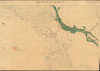
Mesopotamia. Sheet No. 1. Basrah. No.888 D.D.D. 1917 (2.D.O.) S.I. 2000.
Indian Army's Showcase Campaign in the Great War.
- Digital Map Information
- Suitable for large format printing
- Full resolution TIFF file
- ICC color profile embedded
- Delivered instantly via download link
Indian Army's Showcase Campaign in the Great War.
This is a rare 1917 Survey of India map focusing on the key strategic regions of Basra-Zubair in south-eastern Iraq and the adjacent Khorramshahr area of Persia, and it is one of the first maps to show Abadan, the first oil boomtown of the Middle East. It was also a showcase theater for the employment of units of the Indian Army, whose officers were given charge of the campaign at the beginning of the war.A Closer Look
The map is centered on Basra and the Shatt al-Arab River (the confluence of the Tigris and Euphrates), with its date groves printed in green. The map shows roads suitable for wheeled traffic, camel roads, mule paths, foot paths, telegraph lines, wells, oil wells, mosques, imamzadehs (a shrine-tomb of a holy person in Shi'a Islam), forts, watch-towers, deserted villages, and springs, pipelines, graves, trigonometrical stations, post offices and telegraph offices, and camping grounds. It is the most detailed wartime map of the Basra area, this being the location of the British/Indian Headquarters in Iraq during the campaign.Abadan
While there are oil wells marked throughout the map, there is a particular accumulation of wells and refineries in and around Abadan (on the far right), which was the Middle East's first oil 'boomtown.' It appears here along with the Anglo-Persian Oil Company (A.P.O.C.) Refinery. Rich oil fields were discovered here in the early 20th century, and in 1909, secret negotiations with the British led to the formation of the Anglo-Persian Oil Company, which completed its refinery here in 1912. This company would play a central role in Iran's political and economic life throughout the 20th century.A Mess in Mesopotamia
Both the British and Ottomans initially considered Mesopotamia to be a secondary theater of war, but Britain became concerned about ensuring its position on the Persian Gulf and its interests in Persia, especially the oil fields of Abadan. Consequently, the British were prompt to send a military force from India (not Britain), as had been agreed before the war, to protect Abadan in 1914. The Indian Army contributed the majority of the allied forces to the campaign in Mesopotamia against the Ottoman Empire (some 700,000 troops by the end of the war). A decision made in part to 'enhance British prestige' in the eyes of India's Muslim population, whom the British feared might be sympathetic towards the Ottomans. In late November 1914, the British landed at Fao (al-Faw, just south of the area shown here), captured Basra, and, in April 1915, repelled an Ottoman counterattack. These successes prompted calls for British troops to march all the way to Baghdad, especially from politicians who saw such a move as symbolically important, though military planners had doubts about the feasibility of such an ambitious campaign.Staying close to the Tigris and Euphrates, British forces won a succession of small battles but gradually reached far beyond their supply lines, as military leaders had feared. With time to prepare, in November 1915, the Ottomans successfully defended Baghdad and forced the British to retreat to Kut, where they were besieged, and, after a six-month siege and failed British relief efforts, were forced to surrender. Some 13,000 British troops were taken into captivity, many of whom did not survive to the end of the war amid the brutal prisoner-of-war conditions.
After this humiliating defeat for the British, both sides tried to marshal their meager resources, and the British took the time to train new forces and prepare supplies for a long campaign in the interior of Mesopotamia. From late 1916 into early 1917, renewed British efforts recaptured Kut and captured Baghdad, and pushed on to Mosul by the end of hostilities in 1918 (the Armistice of Mudros). Although ultimately successful, the Mesopotamia Campaign forced Britain to divert resources from other theaters. However, at least for one faction of the military leadership, this was a price well worth paying to secure India and connections to it. The rather arbitrary front lines at the time of the armistice helped determine the borders of the British Mandate for Mesopotamia (later Iraq), which were hashed out over the following months and years.
Publication History and Census
This map was prepared (heliozincographed) by the Survey of India based in Dehra Dun in 1917, having been commissioned by the General Staff of the Indian Army for the use of senior officers. It is quite rare; we are only aware of one cataloged example, held by the Staatsbibliothek zu Berlin.Cartographers
Survey of India (1767 - Present) is India's central engineering agency in charge of mapping and surveying the country. It was founded in 1767 by Major James Rennell, who took the post of first Surveyor General, with the mission to map and consolidate the territories of the British East India Company. The Survey undertook the Great Trigonometrical Survey between 1802 and 1852 in an attempt to accurately measure the Indian Subcontinent - considered one of the greatest feats of mapping of all time. It also sponsored clandestine surveys, at times disguised as Buddhist pilgrims, to infiltrate and map Tibet, then a closed country. With India's independence in 1947, the Survey was folded into the new Indian government, which it remains part of to this day. Further Details...
Sidney Gerald Burrard (August 12, 1860 - March 16, 1943) was a British Baronet and army officer who served as the Surveyor General of India. Burrard was born on the Isle of Wright at his hereditary estate, The Mount. He studied at Lymington and then Uppingham School where he exhibited a proficiently at mathematics. From 1874 he attended Wellington College from whence his mathematical talents earned him an April 6, 1879 commission in the Royal Engineers. As part of the Royal Engineers he studied at the School of Military Engineering at Chatham. Completing his education he was dispatched to India in 1992 to join the Bengal Sappers and Miner at Roorkee. He accompanied the 1884 Zhob Valley Expedition to Baluchistan. Also in 1884, he joined the Survey of India where his worked focused on correcting triangulation errors. He severed for a time in the Red Sea before becoming Superintendent of the Trigonometrical Survey of India in 1889. In 1908 he was promoted to Surveyor General. He was honored as a Companion of the Order of the Star of India (CSI) in 1911, and promoted to Knight Commander of the Order of the Star of India (KCSI) in 1914. In 1913 he received the Victoria Medal from the Royal Geographical Society. Burrard retired from military life in 1919. He succeeded to his family Baronetcy in 1933. After his second wife died in 1938, he fell into despondency and died in 1943. Further Details...
Condition
Very good. Some light toning, repaired fold splits, and dampstaining.
References
OCLC 1235951984.