
1561 Ruscelli / Gastaldi map of Muscovy

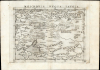
Moschovia Nuova Tavola.
Among the Earliest Acquirable Contemporary Maps of Russia.
- Digital Map Information
- Suitable for large format printing
- Full resolution TIFF file
- ICC color profile embedded
- Delivered instantly via download link
Among the Earliest Acquirable Contemporary Maps of Russia.
This is the 1561 first Ruscelli edition of Giacomo Gastaldi's map of Muscovy, one of the earliest acquirable modern maps of Russia. It is among the earliest obtainable maps to include Paolo Giovio's geography from the Muscovite Embassy.A Closer Look
The map spans from the Black Sea and the Caspian Sea in the south to the Barents Sea in the north (here termed Oceanus Scythicus). The Baltic Sea is glimpsed at the western limit of the map, and it extends eastward to the mouth of the Volga. An unnamed tributary to the Volga - arguably the Kama - is shown with its source lake far to the northeast. The Dnieper River, with many tributaries, is mapped in the west, with its source indicated. The River Dvina, with four tributaries, is shown emptying into the northern ocean. The map is centered on Muscovy. Moscow is labeled, and the Moscow River (amidst a confusion of tributaries) flows into the Volga. Riga lies to the west; the unnamed Daugava River connects to the Volga via a lake. Throughout the map, forests are indicated pictorially. In the steppes beyond the Volga, the domains of the Nogai and Astrakhan Tartars are named. An Italian note describes them as tent-dwelling nomads; indeed, their tents are depicted on the map.Sources
Gastaldi's map was not based on a firsthand survey, but is derived instead from a description provided to scholar and papal confidant Paolo Giovio by Muscovite diplomat Dmitry Gerasimov (Дмитрий Герасимов, c. 1465 - c. 1535). In 1525, Giovio published his report of the Muscovite Embassy - Libellus de legatione Basilii - which included Gerasimov's description of the Grand Duchy, and was accompanied by a map (which now survives in only two known examples). Gastaldi did not produce a rote copy of Giovio's map; the proportions were changed, perhaps to make it more consistent with the Ptolemaic framework of the southern parts of the map and Gastaldi's understanding of the northernmost latitudes. But the courses of most of the river systems, and the bulk of the place names, indicate that Gastaldi's mapping derived, if not from Giovio's map, then from his text.Gastaldi made several amendments to Giovio's map. He removed Giovio's river connecting Novgorod's lake to the Baltic. Where Giovio conjoined the Dnieper River with the Volga at its source in the 'Lago Bianco,' Gastaldi separated them, giving the Dnieper its own source and identifying it as such on the map. Gastaldi also includes 'Red Russia' and names Kyiv (Kiova), albeit mis-transcribing it as 'Riova'. It is absent from Giovio's map in any spelling.
Gastaldi's geography made its first appearance in his 1548 Ptolemy, prior to the 1549 Herberstein map of Muscovy (which Gastaldi's map does not resemble and bears no relation to).
Publication History and Census
This map was first engraved, probably by Giulio Sanuto, for the 1561 Valgrisi edition of Ruscelli's La Geographia di Claudio Tolomeo…. The maps of this edition were engraved two-to-a-plate, and consequently, the platemark runs off the edge of the sheet at the top on first state examples of the map. By the time the edition of 1574 was printed, the plates had been cut in two. Thus, later examples exhibit a platemark all the way around. We see eleven examples of the separate map in OCLC in various editions, five of which are categorized as belonging to the 1561 Valgrisi edition. It appears on the market from time to time.Cartographers
Girolamo Ruscelli (1500 - 1566) was an Italian polymath, humanist, editor, and cartographer active in Venice during the early 16th century. His work as a polygraph - a writer on many subjects, producing, editing, and copying content for the new printing industry - required erudition in a broad array of fields. Born in Viterbo, Ruscelli lived in Aquileia, Padua, Rome, and Naples before relocating to Venice, where he spent much of his life. Cartographically, Ruscelli is best known for his important revision of Ptolemy's Geographia, which he published in 1561, with further editions as late as 1599. Ruscelli's work represented a marked improvement on Gastaldi's 1548 Ptolemy, presenting both the ancient and modern maps in larger, more clearly-engraved examples. His edition also included maps not present in Gastaldi's Ptolemy, including the first double-hemisphere world map to appear in a Geography, the earliest mapping of the British Isles from an English source, and the notorious and influential Zeno map of the North Atlantic. Ruscelli is also listed as the editor of such important works as Boccaccio's Decameron, Petrarch's verse, Ariosto's Orlando Furioso, and various other works. In addition to his well-known cartographic work, many scholars associate Ruscelli with Alexius Pedemontanus, author of the popular De' Secreti del R. D. Alessio Piemontese. This well-known work, or "Book of Secrets," was a compilation of scientific and quasi-scientific medical recipes, household advice, and technical commentary on a range of topics that included metallurgy, alchemy, dyeing, and perfume making. Ruscelli, as Alexius, founded an "Academy of Secrets," a group of noblemen and humanists dedicated to unearthing "forbidden" scientific knowledge. This was the first known experimental scientific society and was later imitated by a number of other groups throughout Europe, including the Accademia dei Secreti of Naples. Further Details...
Giacomo Gastaldi (c. 1500 - October, 1566) was an Italian astronomer, cartographer, and engineer active in the second half of the 16th century. Gastaldi (sometimes referred to as Jacopo or Iacobo) began his career as an engineer, serving the Venetian Republic in that capacity until the fourth decade of the sixteenth century. During this time he traveled extensively, building a large library relating to voyages and exploration. From about 1544 he turned his attention to mapmaking, working extensively with Gextantiovanni Battista Ramusio, Nicolo Bascarini, and Giovanbattista Pedrezano, as well as taking private commissions for, among others, Venice's Council of Ten. He is credited with the fresco maps of Asia and Africa still extant in the map room of the Doge's Palace. Gastaldi was also one of the first cartographers to embrace copper plate over woodblock engraving, marking an important development in the history of cartography. His 1548 edition of Ptolemy's Geographia was the first to be printed in a vernacular; it was the first to be printed in copperplate. As with his Swiss/German contemporary Münster, Gastaldi's work contained many maps depicting newly discovered regions for the first time, including the first map to focus on the East Coast of North America, and the first modern map of the Indian Peninsula. His works provided the source for the vast majority of the Venetian and Roman map publishers of the 1560s and 70s, and would continue to provide an outsize influence on the early maps of Ortelius, De Jode, and Mercator. Further Details...
Giulio Sanuto (fl. 1540 – 1580) was a Venetian engraver. He was born the illegitimate son of Cavaliere Francesco di Angelo Sanuto; With his brother, the cartographer and scientific instrument maker Livio Sanuto (1520 – 1576) he produced an array of some of the most important geographical works produced in Venice during the second half of the sixteenth century. These included a 27-inch globe and the 1588 12-sheet atlas, Geografia della Africa. Giulio's career is singluar among Venice's engraves in that it appears to have been equally based on artistic, figurative work as well as his cartographic works. Giulio is more broadly known for a small but sought-after selection of decorative engravings; no more than twelve of these can be attributed confidently to him, including the monumental Apollo and Marsyas, measuring over 1.30 meters wide. Whilst Sanuto's engravings were generally based upon the designs of other artists, his work was both ambitious and grand, and he often signed these works. Further Details...
Paolo Giovio (April 19, 1483 - December 11, 1552) was an Italian historian, biographer, and prelate. He initially trained as a physician in Pavia and Padua, completing his schooling in 1511. He worked as a physician in Como, but fled the plague to Rome in 1513, where he found a position in the papal court. While he began to study and write history, he continued working in medicine: in 1517, he was made personal physician for Cardinal Giulio Giuliano de Medici, future Pope, who would take the name Clement VII in 1523. His skill as a writer was not lost on his patron: the Pope assigned him to accompany Muscovite diplomat Dmitry Gerasimov (Дмитрий Герасимов, c. 1465 - c. 1535) on his 1525 embassy to Rome, on the strength of which Giovo would record a description of Muscovite Geography, resulting in a seminal map which would form one of the pillars of the early mapping of Russia. Giovio would, in 1528, become bishop of Nocera de Pagani. Giovo returned to Como in 1536, where he flourished as a collector of art, antiquities, and curiosities from the New World. He sought but was denied the title of Bishop of Como in 1549. He died in Florence in 1552. Further Details...
Source
Ruscelli, G., La Geografia di Claudio Tolomeo Alessandrino…, (Venice: Valgrisi) 1561.
Beginning in 1561, Girolamo Ruscelli published this important, expanded edition of Giacomo Gastaldi's 1548 Ptolemy. Its maps, engraved in Venice by Giulio Sanuto, were in the main based directly upon those in Gastaldi's 1548 work. The maps were larger format than Gastaldi's, however, and Sanuto's engraving was far clearer and more legible than those appearing in the 1548 work. There are some important additions that distinguish Ruscell's Ptolemy from Gastaldi's. Ruscelli's work contained a map of the habitable world according to Ptolemy, which the Gastaldi lacked; also, the double-hemisphere map appearing in the Ruscelli was new and did not appear in the Gastaldi. Ruscelli's modern map of England was based on the work of George Lily, rather than on the Waldseemüller-derived map appearing in the Gastaldi; the Ruscelli map is the earliest generally available map of England based on firsthand knowledge. In a fateful innovation, Ruscelli's work included Septentrionalium partium nova tabula,the first copy of Nicolo Zeno's 1558 fraud Carta da Navegar, which introduced a novel mapping of the northern parts of the world, including the phantom islands of Frisland, Icaria, Drogeo, and Estotiland. Had Ruscelli not copied the Zeno, which had a narrow, brief publication, this preposterous geography would have probably not taken hold. Its inclusion in Ruscelli's beautiful, authoritative, and popular work would lead to the adoption of the Zeno map by Mercator, Ortelius, Plancius, and their successors, baffling scholars for centuries. Ruscelli's Ptolemy had a long publication history, cementing the influence of the work. It appeared both in Italian and Latin editions, all printed in Venice, throughout the latter 16th century:
- 1561 La Geographia di Claudio Tolomeo Alessandrino, Italian. Venice, Vincenzo Valgrisi.
- 1562 Geographia Cl. Ptolemaei Alexandrini, Latin. Venice, Vincenzo Valgrisi.
- 1564 La Geographia di Claudio Tolomeo Alessandrino, Italian. Venice, Giordano Ziletti.
- 1564 Geographia Cl. Ptolemaei Alexandrini, Latin. Venice, Giordano Ziletti.
- 1574 La Geographia di Claudio Tolomeo Alessandrino, Italian. Venice, Giordano Ziletti.
- 1598 Geographia di Claudio Tolomeo Alessandrino, Italian. Venice, heirs of Melchoir Sessa.
- 1599 Geographia di Claudio Tolomeo Alessandrino, Italian. Venice, heirs of Melchoir Sessa.
Maps from the above four editions are distinguishable from later issues by their platemarks, which run off the top of the sheet. (The maps were engraved two-to-a-plate head-to-head, and printed simultaneously. Some examples of the uncut sheets have survived.) There is some evidence that, during the course of the publication of the 1564 Latin edition, Ziletti had begun to divide the plates. The map of the ancient world in the editions above was based on Ptolemy's second, curvilinear projection; the Zeno map appears on its first plate.
Condition
Excellent, some faint soiling at corners. Else a bold, sharp example.
References
OCLC 891451022. Rumsey 11311.087. Bellingeri, Giampiero and Milanesi, Marica, 'The Reappearance of the Lost Map of Muscovby by Paolo Giovio (1525)', Imago Mundi, vol 72:1 pp. 47-51.