This item has been sold, but you can get on the Waitlist to be notified if another example becomes available, or purchase a digital scan.
1796 Carey / Lewis Map of New Jersey
NewJersey-carey-1796$200.00

Title
The state of New Jersey, compiled from the most authentic information.
1796 (dated) 18.5 x 12 in (46.99 x 30.48 cm) 1 : 601920
1796 (dated) 18.5 x 12 in (46.99 x 30.48 cm) 1 : 601920
Description
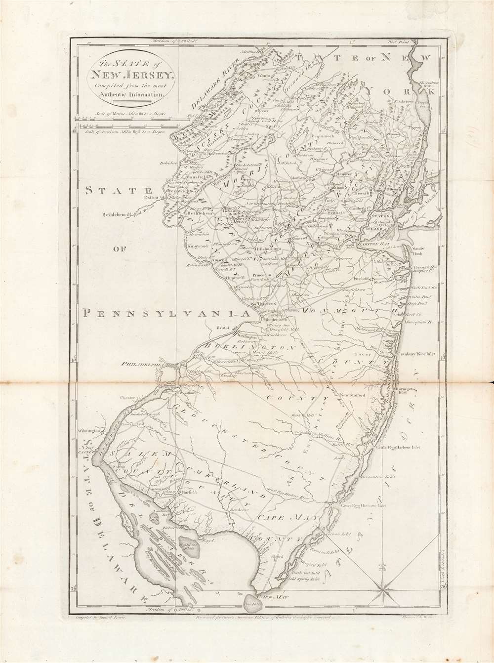
Here is Mathew Carey and Samuel Lewis' c. 1796 map of New Jersey, made for Carey's General Atlas, the first atlas produced and published in the American Republic. It portrays the state in the years just after the American Revolution, in which it had played a central role.
As with many of the maps in the atlas, obsolete and atypical spellings of place names appear here. 'Turky,' to the west of Elizabeth, no longer exists, while 'Tappan Sea' has since lost out to the Dutch styling of its name. The 'Dividing Line of East and West Jersey' running northwest-southeast refers to the earlier division of the British province until 1702; legal disputes continued for years after their merger and the division maintained social and cultural significance long after it had become legally defunct.
A Closer Look
Roads, towns, mills, rivers, lakes, mountains, coastal sandbars, and the borders between counties and states are depicted in great detail. Philadelphia, New York City, and large towns outside the borders of New Jersey are illustrated. This map would have had some added significance for its makers, as Carey and his collaborators were based in Philadelphia, which also serves as Prime Meridian for the maps in the atlas.As with many of the maps in the atlas, obsolete and atypical spellings of place names appear here. 'Turky,' to the west of Elizabeth, no longer exists, while 'Tappan Sea' has since lost out to the Dutch styling of its name. The 'Dividing Line of East and West Jersey' running northwest-southeast refers to the earlier division of the British province until 1702; legal disputes continued for years after their merger and the division maintained social and cultural significance long after it had become legally defunct.
New Jersey and the American Revolution
New Jersey played a central role in the American Revolutionary War (1775 - 1783), leading to it sometimes being dubbed the 'Crossroads of the Revolution.' More than a dozen important battles and many more smaller engagements were fought there. Morristown served as the revolutionaries' military capital for much of the conflict. In 1783, Nassau Hall at Princeton University briefly served as the capital of the nation and housed the Continental Congress, during which it was informed of the signing of the Treaty of Paris.Publication History and Census
This map was compiled by Samuel Lewis and engraved by William Barker for the 1795 or 1796 edition of Carey's General Atlas (sometimes subtitled American Edition of Guthrie's Geography improved). Its distribution is difficult to firmly establish, both due to uncertainty over its date and because the OCLC catalog listings include digitized copies along with physical examples. The physical map is cataloged among the holdings of around twelve institutions, while the entire atlas is somewhat more widely distributed among universities and research institutions in the United States and Europe.CartographerS
Matthew Carey (January 28, 1760 - September 16, 1839) was a Dublin born publisher who established himself in Philadelphia in the late 18th and early 19th century. A young man of socially progressive views, Carey's first known publication, produced when he was but 17 years old, was a pamphlet criticizing dueling. Another pamphlet, issued in the same year, attacked the Irish penal code. Shortly afterwards, in 1779, legal issues, possibly arising from his liberal political activism, forced Carey to flee to Paris. In Paris, Carey had the good fortune to befriend the visiting American diplomat and founding father, Benjamin Franklin (1706 - 1790). As an Irishman chafing under the rule of England, Carey sympathized with and admired the American revolutionary. The liberally minded pair struck up a lifelong friendship and Carey was hired to work at Franklin's press in Passy, France. A year later, Carey returned to Ireland and resumed his politically provocative publishing career with The Freemans's Journal and The Volunteer's Journal. It didn't take long for political pressure to once again force Carey from Ireland - this time to America (1784). Although largely without funds, Carey convinced Gilbert du Motier, Marquis de Lafayette (1757 - 1834), who he knew from Franklin's Paris circle, to lend him funds to establish a new publishing concern in Philadelphia. Despite this loan, Carey's firm remained under financed and opened on a shoestring budget. It was most likely his limited budget that led Carey to some of his most important publishing innovations. At the time cartographic publishing was dominated by large printing houses in London and Paris where most, if not all, of the work was completed in house. Without the finances to emulate this large publishing houses, Carey was forced to outsource much of his publishing work. This set the stage for subsequent American publishers who, in order to compete effectively with European firms, relied on an often bewildering network of alliances and collaborations. Carey was also a master of republishing many of his own maps in multiple different atlases and formats to maximize their profitability. His most important work is without a doubt the 1795 issue of the American Atlas the first atlas to be published in America. Carey died in 1839 but was succeeded by his son Henry Charles Carey (1793 - 1879) who, in partnership with his brother-in-law Isaac Lea (1792 - 1886), published numerous important maps and atlases under the Carey and Lea, Lea Brothers, and Lea and Blanchard imprints. More by this mapmaker...
Samuel Lewis (c. 1754 - 1822) was an American engraver, cartographer, draftsman, and geographer active in Philadelphia in the first of the 19th century. Though is place of birth is uncertain, most agree that Lewis emigrated from Dublin, Ireland, in the late 18th century. Lewis' earliest cartography work was produced in partnership with the well-known Philadelphia publishers Matthew Carey and Henry Schenk Tanner. In 1804, with the intention of republishing high quality English maps in the United States, Lewis partnered with the eminent British map publisher Arron Arrowsmith. Their first joint publication was A New and Elegant General Atlas, but many others followed including an American edition of Arrowsmith's important double hemisphere wall map of the world. Arrowsmith also worked with Jedidiah Morse, among other important American cartographers of the period. Ralph Brown considers Lewis to be "the most enterprising commercial map-maker of the period … " Lewis is best known for his map related to the expedition of Meriwether Lewis (no relation) and William Clark. In 1814 Lewis, copying directly from William Clark's manuscript, issued A Map of Lewis and Clark's Tracks across the Western Portion of North America. This important document was the first published map derived from the Lewis and Clark Expedition and profoundly transformed the cartography of the American northwest. Samuel Lewis of Philadelphia should not be confused with Samuel Lewis of London, another cartographer active during roughly the same period. Learn More...
William Barker (June 29, 1770 - April 19, 1805) was an engraver active in Philadelphia un the late 18th and early 19th centuries. Barker was born in Philadelphia, the son of Elihu Barker (17?? - 1792). Both father and son worked for the firm of Mathew Carey (1760 - 1839) and engraved maps for Carey's American Atlas, considered the first general atlas published in America. He appears in Philadelphia directories for 1795 - 1796 and 1800 - 1809. His business may have been carried on by a son of the same name, but it is unclear. Learn More...
William Guthrie (1708 - March 9, 1770) was a Scottish historian, journalist, and writer. Born in Brechin, he studied at Aberdeen University with the idea of becoming a parochial schoolmaster. Instead, in 1730, he elected to settle in London and try his hand at literature. He covered parliamentary debates f or the Gentleman's Magazine and soon earned a reputation for being a political writer. He published several scholarly works, including a History of England from the Invasion of Julius Caesar to 1688 in four volumes, and, most notably, his Geographical Historical, and Commercial Grammar. Learn More...
Source
Carey, M., Carey's General Atlas, (Philadelphia: Carey) 1796.
Condition
Average. Wear, verso reinforcement, and discoloration along centerfold, with area of loss at right margin. Light foxing and faint handwriting in margins.
References
Rumsey 2862.032. OCLC 5565266, 950941649, 852229916, 984129915, 163340609 [catalog listings for 1795 and 1796].