
1949 Survey of Egypt Hydrological Map of the Nile River, Egypt

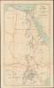

...خَرِيطَة حَوْضِ النِّيل / [Map of the Nile Basin…]. / مصلحة المساحة ١٩٤٩ (٣٤٢ / ٤٩) ١٩٤٩ (٤٦٠ / ٤٩) / [Survey Department 1949 (342/49) 1949 (460/49)].
Grandiose Scheme to tame the Nile.
- Digital Map Information
- Suitable for large format printing
- Full resolution TIFF file
- ICC color profile embedded
- Delivered instantly via download link
Grandiose Scheme to tame the Nile.
This 1949 Survey of Egypt hydrological map presents an ambitious vision for harnessing the Nile: Century Storage, as it was known, proposed a coordinated network of reservoirs designed to capture floodwaters in wet years and release them during drought. The grandiose scheme, proposed by British hydrologist Harold Edwin Hurst, promised to transform the Nile's unpredictable flow into a dependable water supply. Decolonization, competing national interests, and Cold War rivalries prevented its full realization, but portions were implemented, and others laid the groundwork for projects that continue to reshape the Nile Basin.A Closer Look
The map covers northeastern Africa, highlighting the entire course of the Nile from Lakes Albert, Victoria, and other headwaters to the Mediterranean Sea. The map's subtitle encapsulates its scope: 'showing the locations of engineering works, river and rainfall gauge stations, and flow discharge measurements,' with green triangles indicating rain gauges, red dots indicating rain gauges, and blue lines referring to discharge sites, concentrated in southern Sudan, Uganda (here as Buganda بوغندا), and Kenya. All along the course of the river, large dams and barrages (low diversion dams) are labeled in red according to the four types of circles indicated in the legend, referring to extant dams and barrages, those under construction, and proposed future sites, divided into those with a settled location and those in which two locations were under consideration. Settlements, national boundaries, and tributary waterways are indicated throughout.Historical Context
This map is related to the ambitious 'century storage' hydrological megaproject announced in 1945 but drawing on earlier efforts to regulate the Nile's variable annual flow. British hydrologist Harold Edwin Hurst (1880 - 1978) and his colleagues, both British and Egyptian, envisioned the plan. In the 1930s and 1940s, Egypt faced chronic water shortages as drives to improve agricultural production placed greater demands on the Nile's waters, which remained subject to drastic seasonal and annual variations. Though the British had been building dams in Egypt since the 19th century, they could not fully solve larger systemic issues, namely the boom-and-bust cycles of rainy seasons and sometimes multiyear droughts. To address this issue, Hurst, whose career in Egypt lasted more than 60 years, devised a system for storing the Nile's waters in upriver reservoirs, where evaporation is much lower than in Egypt. In preparation for the 'century scheme,' this era saw an unprecedented expansion of empirical data collection, as shown by the profusion of rain and river gauges here.Translating these models into physical infrastructure required major engineering efforts overseen by the Ministry of Public Works. In the decades before independence, Egypt commissioned and managed key hydrological infrastructure works, including the Jebel Aulia Dam in Sudan (1937) to store water specifically for Egyptian seasonal irrigation, the second heightening of the original Aswan Dam (1934), and new control barrages along the Nile Delta and Upper Egypt. Such a system was eminently logical within the context of British imperialism, as most concerned territories were British colonies or protectorates. But this model made less sense in the postcolonial world of nation-states emerging in the post-World War II period.
The data collection, planning, and construction of the 1930s and 1940s established a solid baseline for Nile hydrology, with a legacy lasting long past the 1952 Egyptian Revolution. Some of the proposed dams near the sources of the Nile were indeed constructed, such as the 'Victoria Dam' (سد فيكتوريا) in Uganda, built in the early 1950s as the Owen Falls Dam (now known as the Nalubaale Dam), while others, such as a similar dam at Lake Albert (سد ألبرت) have never been built.
The construction of the Aswan High Dam in Upper Egypt under Soviet guidance in the 1960s effectively killed the 'century storage' scheme. Contrary to Hurst, the Free Officers (including Gamal Abdel Nasser) who led independent Egypt wanted to store water domestically for political reasons, even if it was less efficient in hydrological terms. In recent years, the construction of additional dams on the Nile has in some ways revived Hurst's grand scheme. However, these efforts are less coordinated and more contentious since they are carried out independently by nation-states for their own reasons. The most prominent example is the Grand Ethiopian Renaissance Dam, constructed between 2011 and 2025, an updated version of the Lake Tana Dam (سد بحيرة تانا) proposed here, that has caused considerable acrimony between Egypt and Ethiopia.
Publication History and Census
The Survey of Egypt prepared this map in 1949, and it includes a printed signature of Hamed Suleiman (حامد سليمان), Undersecretary of the Ministry of Public Works. The red overprint in the bottom-right margin suggests that this was a slightly modified second printing (both being dated 1949). The American University in Cairo holds the only known institutional copy of the map.Cartographer
Survey of Egypt (c. 1898 - present; مصلحة المساحة المصرية) was the official surveying body of the Egyptian government from the turn of the 20th century until the founding of the Republic of Egypt. As Egypt was a British Protectorate for most of this period, the survey closely resembled government survey operations in other British colonies and protectorates. However, unlike many other surveys, the Survey of Egypt did not continue under its colonial name in the postcolonial period. Instead, in the independence era, the former Survey became known as the Egyptian General Survey Authority (الهيئة المصرية العامة للمساحة), from 1971 has been affiliated with the Ministry of Irrigation (وزارة الري). Further Details...
Condition
Very good. Light wear along original fold lines. Closed margin tear professionally repaired on verso.
References
OCLC 1226766930. Tvedt, T., The River Nile in the Age of the British: Political Ecology and the Quest for Economic Power, (New York: I.B. Taurus) 2004.