1862 Tackabury / Walling Wall Map of Ontario (Canada West)
Ontario-tackabury-1862$4,500.00


Title
Tackabury's Map of Canada West, drawn from Government and special Local Surveys by H.F. Walling.
1862 (dated) 75 x 60 in (190.5 x 152.4 cm) 1 : 380160
1862 (dated) 75 x 60 in (190.5 x 152.4 cm) 1 : 380160
Description
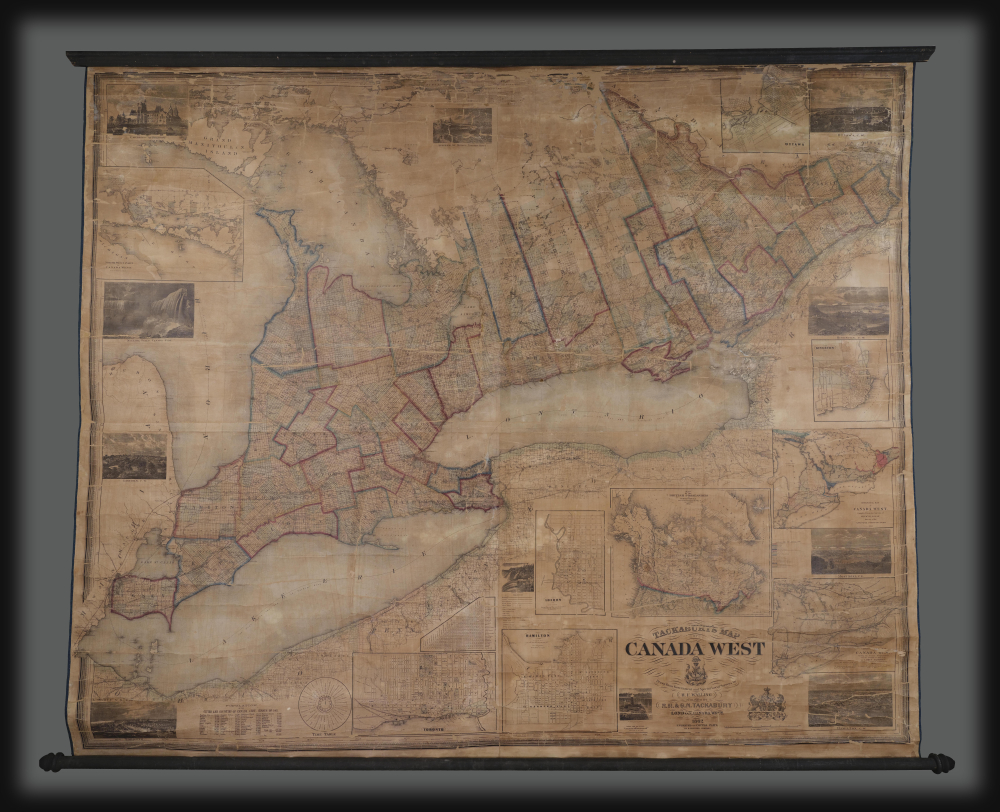
This is Henry Francis Walling's very large-format 1862 wall map of Canada West (formerly Upper Canada and subsequently Ontario), published by Robert M. Tackabury and George N. Tackabury. In addition to its size and magnificent level of detail, it is also significant for capturing this region in a period of political and social transformation, driven by railways, immigration, and moves towards greater political union and autonomy.
Surrounding the main map are inset maps and views of Ottawa, Kingston, Montreal, Hamilton, Niagara Falls, Toronto, London, the University of Toronto, and the North West Part of Lake Huron and Manitoulin Island, some of which incorporate the work of other cartographers like G.W. and C.B. Colton (successors to the firm of Joseph Hutchins Colton), Sir William E. Logan (founder of the Geological Survey of Canada), and Lorin Blodget (a founding figure of climatology in North America). A population table, timetable (as times varied by locality and were not standardized into zones at this time), and coats of arms of Canada and Great Britain also appear, along with an inset map of all the British Possessions in North America (i.e., today's Canada), a miniaturized J. H. Colton wall map.
It is also notable that this map was produced during the U.S. Civil War. Not only did the outbreak of that war signal the dangers of too loose a confederation among territories, but tensions between the Union side and Great Britain due to Britain's continued trade with the Confederacy raised fears of U.S. attacks on British colonies north of the border. These concerns only increased the already prevalent hopes and demands for greater Canadian autonomy, and can be seen as a precursor to Canada achieving dominion status less than a decade later.
A Closer Look
This massive wall map covers Canada West, previously called Upper Canada, and renamed Ontario upon Confederation in 1867. County and district boundaries are traced in hand-color, while townships are shaded and individual land plots are traced, almost always in a uniform grid, which typically resulted in plots of 100 acres, a major inducement to immigrants (discussed below). In northern Ontario, where settlement was sparsest, some townships remain undivided for allotment to settlers, while a large area around and to the north of the Parry Sound Road remained mostly uninhabited by White settlers, though members of several First Nations (Ojibwe, Cree, Oji-Cree, and others) would have been resident there. Additional details like roads, railways, shipping lines, and more also proliferate across the map.Surrounding the main map are inset maps and views of Ottawa, Kingston, Montreal, Hamilton, Niagara Falls, Toronto, London, the University of Toronto, and the North West Part of Lake Huron and Manitoulin Island, some of which incorporate the work of other cartographers like G.W. and C.B. Colton (successors to the firm of Joseph Hutchins Colton), Sir William E. Logan (founder of the Geological Survey of Canada), and Lorin Blodget (a founding figure of climatology in North America). A population table, timetable (as times varied by locality and were not standardized into zones at this time), and coats of arms of Canada and Great Britain also appear, along with an inset map of all the British Possessions in North America (i.e., today's Canada), a miniaturized J. H. Colton wall map.
A Plagiarism Fight
This map caused quite a tiff with fellow map publisher George C. Tremaine, who produced the only other equivalently large wall map of Canada West at the time, with both producing first editions of their maps in 1862. Tremaine argued that the Tackaburys had plagiarized his earlier county maps of the region. However, it is unclear to what extent this was true given Walling's own familiarity with the area, including making his own county maps. The acrimony was also surely connected to the financial difficulties of both firms, given the tremendous upfront costs in producing such a work. Walling in particular appears to have suffered heavy losses due to the terms of his contract with the Tackaburys (though he continued to work with them into the 1880s). Both firms took out space in newspapers to criticize the other, lambasting each other's cartographic and printing methods, accusing each other of plagiarism, and denouncing each other as carpetbagging Americans. (Tremaine lived in Canada but had been born in New York, not far from the Tackabury family, in fact.) For more information on this feud and the Tackabury Brothers, see the online article 'The Tackabury Brothers and their 1862 Canada West Map' by Graham Seeger.Historical Context
This map was produced when this region was undergoing tremendous economic, demographic, and political transformation. Following a pair of rebellions in the late 1830s, Upper and Lower Canada were merged into a union in 1840 and became Canada West and the mostly French-speaking Canada East (the basis for Quebec). The 1840s and 1850s saw significant levels of (Anglophone) immigration, and the population of Canada West more than doubled in the decade after its creation, surpassing that of Canada East for the first time. Along with new immigrants, rail connections with the United States, improved oceangoing ships, and the reduction of tariffs and trade limitations led to a boom in the export of raw materials such as timber and corn. These changes unleashed political forces that agitated for greater representation for the region, leading ultimately to Confederation in 1867.It is also notable that this map was produced during the U.S. Civil War. Not only did the outbreak of that war signal the dangers of too loose a confederation among territories, but tensions between the Union side and Great Britain due to Britain's continued trade with the Confederacy raised fears of U.S. attacks on British colonies north of the border. These concerns only increased the already prevalent hopes and demands for greater Canadian autonomy, and can be seen as a precursor to Canada achieving dominion status less than a decade later.
Publication History and Census
This map was prepared by Robert M. and George N. Tackabury, with significant surveying work done by Henry Francis Walling, and engraved by David Griffing Johnson in 1862. As discussed above, it is a rare wall map of Canada West in this brief but eventful period of Canada's history, along with Termaine's competing wall map of Canada West. The present map was published in several editions, right up until Confederation in 1867, all of which are quite scarce; this first edition is especially so. It is only noted among the holdings of the British Library and the University of Guelph in the OCLC. The Oshawa Museum also holds an example not listed in the OCLC.CartographerS
Robert Middleton Tackabury (1826-1906) and George Neusum Tackabury (1828 - 1894) were Philadelphia-based map publishers active in the middle part of the 19th century. The Tackaburys were born in New York. They published several case maps, pocket maps and atlases in conjunction with Robert Clark and Henry Francis Walling. The firm had actually been founded by the father of Robert M. and George N. Tackabury named James Tackabury (1795-1884), with his own brother John Wesley Tackabury (1804-1877) who emigrated from Ireland to Madison County, NY in 1807. James Tackabury had three sons who all worked for the firm at different points in their life; Robert Middleton Tackabury, George Neusum Tackabury, and Rev. Samuel T. Tackabury (1832-1888). His brother John Wesley Tackabury moved from New York to London, Upper Canada (future Ontario) and may have been involved in Tackabury's output of maps and atlases of Canada in the 1860s and early 1870s (Robert and George Tackabury established an office in London in 1860). Meanwhile, the New York Tackabury's established an office in Philadelphia in the late 1850s, though it is unclear if and for how long either brother actually resided in the city. Beginning in the 1870s, the Tackabury brothers began to shift focus towards maps, atlases, and business directories of states in the American Midwest and new states/territories in the Great Plains. George Tackabury remained in Madison County, new York for the rest of his life, while brother Robert traveled widely, moving to Syracuse, New York around 1870, then to Detroit, Michigan in the mid-1870s, and seems to have moved between Madison County, Syracuse, and Detroit for several years before moving to South Dakota in the mid-1890s and briefly to Los Angeles late in life, probably for health reasons. The firm published under George's name only from the late 1870s, but its continued output of maps related to Michigan and South Dakota strongly suggests Richard's continued involement. The firm's last known publication was an 1893 updated edition of an 1884 map of the Upper Peninsula of Michigan, 'Map showing the military road lands belonging to the estate of James C. Ayer'. More by this mapmaker...
Henry Francis Walling (June 11, 1825 - April 8, 1889) was an American civil engineer, cartographer, surveyor, and map publisher active from the middle to late 19th century. Walling was born in Providence, Rhode Island. He studied/worked at the Providence Athenaeum before discovering a talent for mathematics and surveying. Walling took a position with Samuel Barrett Cushing (1846 - 1888), a Providence-based civil engineer with whom he issued in 1846 a revision of James Steven's Topographical Map of the State of Rhode-Island. Walling established himself independently around 1850 and immediately began preparing a series of town plans focusing on Bristol County, near Providence. Buoyed by widespread interest in his plans, Walling expanded his operations to Massachusetts, where, by 1857, he had produced no less than 50 town plans. Apparently, Walling's business model involved a contract with town officials to produce a certain number of maps, after which he acquired the right to print and sell additional copies on his own account. This work eventually led to Walling's appointment as Massachusetts "Superintendent of the State Map", a designation that began appearing on his maps around 1855. While Walling's work focused heavily on city and county maps, he successfully published three scarce state maps: Maine, Vermont, and Rhode Island. In 1856, Walling relocated his headquarters to New York City, where he had better access to quality lithographers. The Civil War (1861 - 1865) proved difficult for Walling, and diminished sales may have forced him into a partnership with Ormando W. Gray, with whom he published numerous state, county, and national atlases in the 1860s and 1870s. Around 1880, Walling took a post with the U.S. Coast Survey, with whom he worked on various charts until requesting a transfer in 1883 to the newly formed U.S. Geological Survey. Walling remained with the Geological Survey until his untimely death of a heart attack in April 1889. Learn More...
David Griffing Johnson (1808 - April 9, 1863), aka 'Griffin', is a mysterious but significant American engraver and mapmaker active in Portland, Maine, New Orleans, and New York City in the decades preceding the American Civil War (1861 - 1865). Our knowledge of him is scant. He was likely born in Connecticut. We believe him one and the same with David G. Johnson, a map engraver, who first appears in Portland, Maine in 1824, where he had an office at No. 4, Market Square in Gilbert’s Block. He was not a native to that city, instead arriving in 1824 with the intent to establish himself as the city's premier engraver. This seems not to have worked out, but he did produce a few maps, portraits, nautical charts, and novelties. He left Portland in 1830, eventually settling in New York, where we can place him in 1831. In New York he promoted himself as a portrait painter and engraver from 1831 to 1835. He appears to have had little success during this period, but did engrave the plates for the 1833 A Treatise on Topographical Anatomy. Shortly thereafter, he relocated to New Orleans. He was in New Orleans from at least 1838 to 1843, where he set up an engraving and daguerreotype studio. While there, he engraved E. H. Springbett and L. I. Pilié's 1839 Topographical Map of the City and Environs of New Orleans, of which we can frustratingly find no surviving examples but several references. We note correspondence in 1840 between Johnson and Samuel F. B. Morse (inventor of the telegraph and daguerreotype pioneer) asking for advice on daguerreotyping, suggesting that Johnson had difficulty with the process. He returned to New York in 1843, remaining until about 1847, when he issued a map with J. H. Colton. At some point, likely in 1848, D. Griffing Johnson headed west. His 1853 world map and his 1857 North America map both feature a large view of Sutter's Mill with the note, 'Drawn on the spot by D. G. Johnson in 1849'. It is thus believed he was at Sutter’s Mill when gold was discovered or shortly thereafter. There is record of a D. G. Johnson arriving in New York in 1849 on a ship from Jamaica - possibly a transit point having sailed around South America? He was in New York throughout the 1850s to about 1862 or 1863, producing several maps, including a large world wall map in 1853, a North America map in 1853 with 'Thayer, Bridgman and Fanning', and an 1854 North America map with A. J. Johnson, an 1860 world map with Jacob Monk, and an 1862 map of Maine with Henry Francis Walling and Jacob Chace Jr. In 1855 he had an office at 7 Nassau Street, New York. In 1859 he successfully defended himself in New York courts on charges of copyright violation by fellow mapmaker Robert Persall Smith. Regarding D. G. Johnson’s disappearance sometime after 1863, we can only speculate. If our reasoning stands, when was active in Maine in 1824 he would have been at least in his early 20s. Thus by 1863, he would have been in his late 60s, so it is likely he died, but records have been elusive. References: Groce, G.C,. and Wallace, D. H., The New-York Historical Society's Dictionary of Artists in America, 1864 - 1860, p. 353. Smith, M.G., and Tucker, M. L., Photography in New Orleans: The Early Year, 1840 - 1865, p 21-22. Palmquist, P. and Kailbourn, T. R., Pioneer Photographers from Mississippi to the Continental Divide, p. 357. Shettleworth, Earle G., 'Portland, Maine, Engravers of the 1820s', part II, 105 - 109, in Old-Time New England, Volume 61, Number 224 (Spring, 1971). Fales, Marthaq Gandy, 'An Unrecorded Portland Engraver', pages 77-79 in Old-Time New England, Volume 57, Number 207 (Winter, 1967). Learn More...
Joseph Hutchins Colton (July 5, 1800 - July 29, 1893), often publishing as J. H. Colton, was an important American map and atlas publisher active from 1833 to 1897. Colton's firm arose from humble beginnings when he moved to New York in 1831 and befriended the established engraver, Samuel Stiles. He worked under Stiles as the 'Co.' in Stiles and Co. from 1833 to 1836. Colton quickly recognized an emerging market in railroad maps and immigrant guides. Not a cartographer or engraver himself, Colton's initial business practice mostly involved purchasing the copyrights of other cartographers, most notably David H. Burr, and reissuing them with updated engraving and border work. His first maps, produced in 1833, were based on earlier Burr maps and depicted New York State and New York City. Between 1833 and 1855, Colton proceeded to publish a large corpus of guidebooks and railroad maps, which proved popular. In the early 1850s, Colton brought his two sons, George Woolworth Colton (1827 - 1901) and Charles B. Colton (1832 - 1916), into the map business. G. W. Colton, trained as a cartographer and engraver, was particularly inspired by the idea of creating a large and detailed world atlas to compete with established European firms for the U.S. market. In 1855, G.W. Colton issued volume one of the impressive two-volume Colton's Atlas of the World. Volume two followed a year later. Possibly because of the expense of purchasing a two-volume atlas set, the sales of the Atlas of the World did not meet Colton's expectations, and so, in 1856, the firm also issued the atlas as a single volume. The maps contained in this superb work were all original engravings, and most bear an 1855 copyright. All of the maps were surrounded by an attractive spiral motif border that would become a hallmark of Colton's atlas maps well into the 1880s. In 1857, the slightly smaller Colton's General Atlas replaced the Atlas of the World. Most early editions of the General Atlas published from 1857 to 1859 do not have the trademark Colton spiral border, which was removed to allow the maps to fit into a smaller format volume. Their customers must have missed the border because it was reinstated in 1860 and remained in all subsequent publications of the atlas. There were also darker times ahead; in 1858, Colton was commissioned at a sum of 25,000 USD by the government of Bolivia to produce and deliver 10,000 copies of a large format map of that country. Although Colton completed the contract in good faith, delivering the maps at his own expense, he was never paid by Bolivia, which was at the time in the midst of a series of national revolutions. Colton would spend the remainder of his days fighting with the Bolivian and Peruvian governments over this payment, and in the end, after a congressional intervention, he received as much as 100,000 USD in compensation. Nonetheless, at the time, it was a disastrous blow. J. H. Colton and Company is listed as one of New York's failed companies in the postal record of 1859. This led Colton into the arms of Alvin Jewett Johnson and Ross C. Browning. The 1859 edition of Colton's General Atlas lists Johnson and Browning as the 'Successor's to J. H. Colton' suggesting an outright buyout, but given that both companies continued to publish separately, the reality is likely more complex. Whatever the case may have been, this arrangement gave Johnson and Browning access to many of Colton's map plates and gave birth to Johnson's New Illustrated (Steel Plate) Family Atlas. The Johnson's Atlas was published parallel to Colton's atlases well into the 1880s. The Colton firm itself subsequently published several other atlases including an Atlas of America, the Illustrated Cabinet Atlas, the Octavo Atlas of the Union, and Colton's Quarto Atlas of the World. They also published a large corpus of wall maps, pocket maps, and guides. The last known publications of the Colton firm date to 1897 and include a map and a view, both issued in association with the Merchant's Association of New York. Alice M. Colton married August R. Ohman (May 3, 1859 - April 22, 1934) on January 5, 1897. In 1898, Ohman joined the Colton firm, which continued to publish as Colton, Ohman & Co. until 1901. Learn More...
Condition
Good. Overall toning and cracking. Professionally restored and stabilized.
References
OCLC 557799862, 624463754.