
1943 Richard Edes Harrison Map of the Pacific From Three Perspectives

This item has been sold.
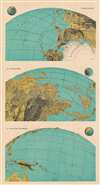
I: From Alaska. III: From Burma. II: From the Solomons.
An amazing example of Harrison's innovative spherical perspective.
- Digital Map Information
- Suitable for large format printing
- File Size: 199.19 MB
- File Type: ZIP / TIFF
- ICC color profile embedded
- Delivered instantly via download link
An amazing example of Harrison's innovative spherical perspective.
This 1943 Richard Edes Harrison map of the Pacific exemplifies his innovative spherical projection, which he employed to good effect in his maps produced leading up to and during the Second World War. Many of Harrison's wartime readers responded enthusiastically to his approach - although isolationist critics complained that his decision to abandon more familiar projections was a polemical choice intended to emphasize the proximity of various theatres of war to American interests - particularly in the maps he produced prior to America's entry into the war. This was less the case with this triple map, printed well into the conflict and focusing on the likely approaches to Japan that might be exploited by the United States.The Maps Themselves
Harrison divides the Pacific Ocean into three different views: from Alaska, from Burma, and from the Solomon Islands. Astute readers in 1943 would have recognized all three as critical battlegrounds for the containment and defeat of Imperial Japan. By employing his spherical projection, Harrison conveys the key island chains pointing at Japan, rather than the sheer vastness of the Pacific. Apart from labeling key locations, Harrison lets the map's visceral depiction of land masses speak for itself, rather than cluttering the images with descriptive text.Publication History and Census
This map was created in 1943 and published by FORTUNE Magazine. One example is cataloged in OCLC and is part of the collection at Pennsylvania State University.Cartographer
Richard Edes Harrison (March 11, 1901 - January 5, 1994) was an American cartographer, scientific illustrator, and designer based in New York City, active principally from the 1930s through the 1970s. His journalistic maps combined unconventional viewpoints, expressive relief shading, and carefully controlled graphic design to explain international geography to a broad readership. Born in Baltimore, Maryland, and raised in New Haven, Connecticut, he graduated from Yale College in 1923 with a major in zoology and a minor in chemistry. After working as a scientific illustrator and architectural draftsman, he entered Yale's School of Fine Arts in 1926 and received an architecture degree in 1930. With architectural work scarce during the Depression, he moved to New York and worked in interior and industrial design. A 1932 Time map assignment launched his career in magazine cartography; he later became a staff cartographer for Fortune before returning to freelance work in 1938, maintaining important associations with Fortune and Life. During World War II, Harrison challenged the familiar north-up, Mercator-centered view of world affairs through polar projections, orthographic views, and oblique perspectives that emphasized the Earth's curvature and the proximity of continents in an age of aviation. His Three Approaches to the U.S. (1940) and The World Divided (1941) made American strategic vulnerability visually immediate, supporting an internationalist understanding of the conflict rather than geographical isolation. His influential Look at the World: The Fortune Atlas for World Strategy appeared in 1944. Although admired for their explanatory power, his departures from conventional orientation, scale, and projection also attracted criticism from professional geographers and cartographers. Harrison taught at Syracuse University from 1945 to 1949 and consulted for government agencies, including the Office of Strategic Services, the State Department, and the U.S. Geological Survey. His later publications included The Ginn World Atlas (1963), and he contributed shaded-relief cartography to The National Atlas of the United States of America. He received the American Geographical Society's Miller Medal in 1968. An enthusiastic birdwatcher with a sustained interest in Central Park conservation, Harrison died in New York City on January 5, 1994; the Library of Congress acquired his professional and personal papers in 1995. Further Details...
Condition
Very good. Exhibits slight wear at junctures of folds.
References
OCLC 45886353.