
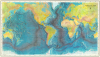
1977 Heezen and Tharp Bathymetric Map of the World


This item has been sold.
World Ocean Floor by Bruce C. Heezen and Marie Tharp.
A triumph for geology and women in science.
A triumph for geology and women in science.
The visually striking and scientifically significant 1977 Marie Tharp and Bruce C. Heezen physiographic map of the world detailing the oceans' floors. The map offers a striking axonometric view of the terrain throughout, with the focus being the seabed. A revolutionary work, it combines genuine scientific work of interpreting and compiling thousands of sonar images, with the exceptional artistry of Heinrich C. Berann. It is the largest map to emerge from the Tharp-Heezen collaboration.Significance
This map represents the culmination of more than 30 years of collaboration between Tharp and Heezen. Their joint efforts, largely led by Tharp, focused on a meticulous sonar mapping of the oceans' floors. The present map is the fourth and final in their series - the others, published between 1957 and 1964, are more regional. In aggregate, their work led to the discovery of the Mid-Atlantic Rift and the Mid-Atlantic Ridge, and redefined both submarine geology and our understanding of plate tectonics. Moreover, Tharp's work was pioneering in elevating the role of women in the sciences.Publication History and Census
This map was painted by Heinrich C. Berann with the assistance of Heinz Vielkind. It was published by the United States Navy, Office of Naval Research, and dedicated to Hezeen, who died in the same year, 1977. Berann's original painting (G9096.C22 1977.B4), based upon research completed by Bruce C. Heezen and Marie Tharp of the Geological Department at Columbia University, survives at the Library of Congress. The map is well represented in institutions, but few examples have found their way to the private market.Cartographers
Marie Tharp (July 30, 1920 - August 23, 2006) was a prominent American oceanographic cartographer and geologist - recognized as a pioneer in the male-dominated world of geology. Tharp was born in Ypsilanti, Michigan. She was introduced to mapmaking through her father, who was a surveyor for the U.S. Department of Agriculture. She studied at the University of Ohio, earning Music and English degrees. During World War II, she earned a Masters in Geology at the University of Michigan, graduating in 1944, and later a second bachelor's in mathematics (1948). She first worked as a research assistant at Lamont Geological Laboratory in Columbia University in New York. Tharp was Bruce Charles Heezen's (1924 - 1977) assistant while he was a graduate student, and he gave her the task of drafting seafloor profiles. Her discoveries of the Mid-Atlantic Rift and the Mid-Atlantic Ridge, while initially dismissed because of her gender, eventually led to a life-long collaboration with Heezen. Today, Tharp is best known for her decades long project to map the ocean floors with sonar imaging. This revolutionary work contributed to our modern understanding undersea geography, plate tectonics, and continental drift. Ironically, women at that time were unwelcome on scientific marine voyages, so while she mapped the oceans, she never personally went to sea. Her published maps include the North Atlantic (1957), South Atlantic (1961), Indian Ocean (1964), and the world (1977). She remained at Columbia University until retiring in 1983. Further Details...
Bruce Charles Heezen (April 11, 1924 - June 21, 1977) was an American geologist active at New York's Columbia University. Heezen was born in Viton, Iowa. He graduated from the University of Iowa in 1947 and went on to an MA (1952) and PhD (1957) at Columbia University. There he met the pioneering female geologist, Marie Tharp (1920 - 2006), with whom he collaborated to map the ocean's floors for some 30 years. Tharp was Heezen's assistant while he was a graduate student. When she showed Heezen that her plotting of the North Atlantic revealed a rift valley, Heezen dismissed it as 'girl talk'. She persisted and they eventually discovered that not only was there a North Atlantic rift valley, but a mountain range with a central valley that spanned the earth. Heezen died of a heart attack in 1977 while aboard the NR-1 submarine studying the Mid-Atlantic Ridge near Iceland. Further Details...
Heinrich Caesar Berann (March 31, 1915 - December 4, 1999) was an Austrian cartographer and topographical painter. Berann was born in Tyrol, Austria, to a family of artists. He studied painting at the Federal School of Art and Design at Innsbruck from 1930 - 1933. In addition to pursuing his own art, Berann worked as a commercial artist and graphic designer. Its first successful painting was a 1934 promotional panoramic map of the Grossglockner High Alpine Road, a newly opened mountain road in Austria. This led to additional commissions, most of which were for topographical paintings, views, and other cartographic-adjacent projects. His work was often painstaking; for example, for his 1966 panorama of the Himalayas for National Geographic, he made preliminary sketches by flying around Mount Everest in a chartered plane. His work gained a following and, over a long career, he produced more than 100 topographic paintings, including the seminal 1977 bathymetric map of Marie Tharp and Bruce C. Heezen, and panoramas for the U.S. National Park Service: North Cascades National Park (1987), Yosemite National Park (1989), Yellowstone National Park (1991), and finally Denali National Park and Preserve (1994). Further Details...
Condition
Very good. Some minor crinkling.
References
OCLC 3417253. North, Gary. W., 'Marie Tharp and Her Ocean Floor Maps', The Portolan, #79, 2010. Library of Congress, G9096.C22 1977.B4.