
This item below is out of stock, but another example (left) is available. To view the available item, click "Details."
Details
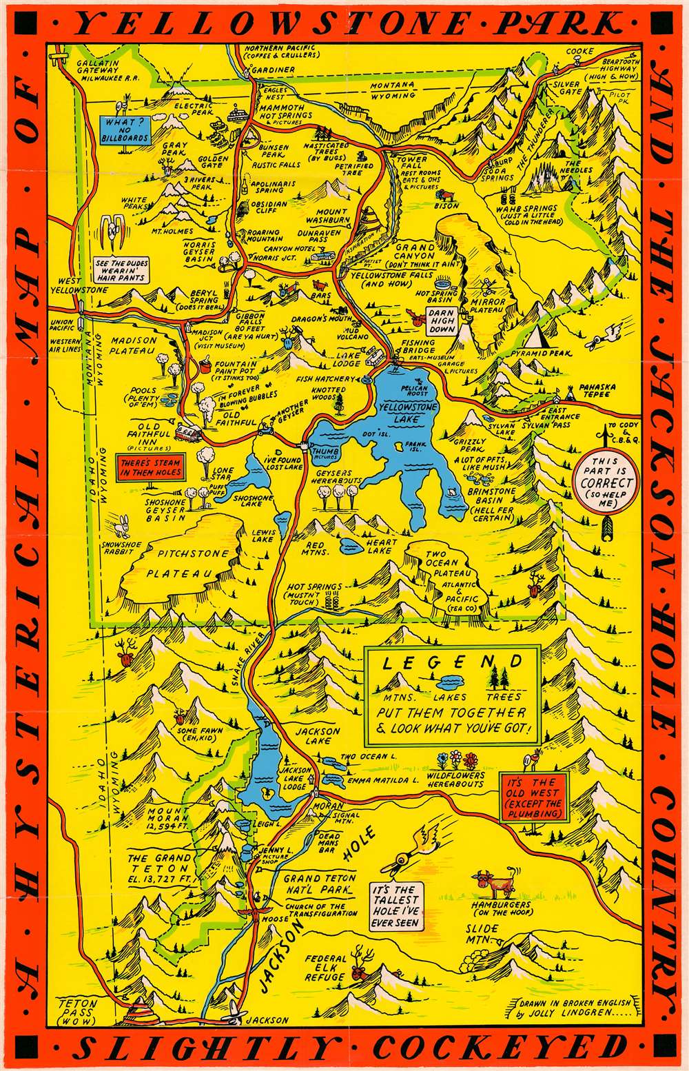
1936 Jolly Lindgren Pictorial Map of Yellowstone Park and Jackson Hole
$450.00
1936 Jolly Lindgren Humorous Pictorial Map of Yellowstone Park and Jackson Hole
YellowstoneParkJacksonHole-lindgren-1936$225.00

Title
A Hysterical Map of Yellowstone Park and the Jackson Hole Country. Slightly Cockeyed.
1936 (undated) 21.75 x 14 in (55.245 x 35.56 cm) 1 : 355000
1936 (undated) 21.75 x 14 in (55.245 x 35.56 cm) 1 : 355000
Description
This is a hilarious c. 1936 Jolly Lindgren pictorial map of Yellowstone National Park and Jackson Hole, Wyoming. The map depicts the region from Idaho to the Absaroka Range and from Montana to Jackson. Major roadways are marked in red with important locations, topography, and more illustrated pictorially. Humorous asides and illustrations are present throughout. Some of the amusing annotations include:
It has been argued that the bright colors and humorous nature of the map are intended to inspire good spirits against the backdrop of national social and economic depression - but such might be said of the entire genre of cartoon pictorial maps which were experiencing a golden age at this time.
- Old Faithful singing 'I'm Forever Blowing Bubbles'
- Fountain Paint Pot (It Stinks Too)
- Yellowstone Falls (And How)
- Wahb Springs (Just a Little Cold in the Head)
- Hamburgers (on the Hoof)
- Hot Springs (Mustn't Touch)
It has been argued that the bright colors and humorous nature of the map are intended to inspire good spirits against the backdrop of national social and economic depression - but such might be said of the entire genre of cartoon pictorial maps which were experiencing a golden age at this time.
Publication History and Census
This map was part of a series of maps drawn by Jolly Lindgren. Called 'Hysterical Maps' to differentiate their style and intention from the more common 'historical maps,' there are sister maps of several other great national parks as well as some universities. This map was drawn by Lindgren c. 1936 and has been catalogued as being part of the collection at the Montana State University Library, the University of Wyoming, and the David Rumsey Map Collection at Stanford University.Cartographer
Lindgren Brothers (1928 – 1971) was a Spokane, Washington, based printer known for issuing humorous souvenir auto decals, maps, and posters. The firm was founded as a sign-painting company by Hjalmer 'Jolly' Lindgren (1895 - September 1952) and his brother Oscar 'Ott' Lindgren (1893 - 1967), born in Wisconsin to Swedish immigrants. Neither brother had middle names when they went off to fight in World War I (1914 - 1818), but as the government required it, they adopted Jolly and Ott, which stuck with them for life. Jolly was in charge of the art department and Ott was in charge of the business aspects of the firm. The company began as printers and sign makers, and also became innovators in silkscreen printing, and as the Great Depression deepened, Jolly began producing 'hysterical maps'. He declared at the time, ‘What this country needs now is something to put a smile on people's faces.' The maps are graphically interesting and intended, as the titles suggest, to amuse. The brothers focused on producing maps of popular tourist attractions, and the great national parks of the West were an obvious choice. They produced maps of Yellowstone, the Grand Canyon, Glacier, Zion, Bryce Canyon and others through the early 1940s. Following a hiatus during World War II (1939 - 1945), the company began producing car decals, some of which were simplified versions of the ‘hysterical maps'. The company sold more than ten million decals in a good year. In 1949, the company was renamed the Lindgren-Turner Company when their traveling salesman, Theodore 'Ted' Turner, Jr. (1902 - 1989), who had been with the firm since 1930, became a partner. Jolly died unexpectedly at 57 while visiting his daughter in Boise, Idaho. The firm continued under his brother, Oscar. William Shigeo Terao (1915 - 1990), who was hired after World War II by the Lindgrens and eventually became the firm's art director, created two more hysterical maps following Jolly's death. The company's last great success, after the decal market had become too competitive, was a sign that read 'No Trespassing, Survivors will be Prosecuted'. The signs became a massive success, eventually being sold in every Woolworth's department store nationwide - all 2,228 locations. Ott died in 1967 at the age of 74, leaving Turner as the last member of the original team. He, in turn, sold the firm to the Emblem Manufacturing Company based in Los Angeles, in February 1971 and he and his wife moved to New Mexico three years later to be closer to their daughter. Turner wrote a history of the Lindgren-Turner Company during his retirement and died at the age of 87 in 1989. More by this mapmaker...
Condition
Very good. Verso repairs to fold separations. Light wear along original fold lines. Blank on verso.
References
Rumsey 8070.000. OCLC 953572048 ; 1065956227.
You May Also Like


