
American Bank Note Company (sold)

American Bank Note Company (1795 - present), known today simply as ABCorp, is an American corporation that traces its origins to the 1795 firm Murray, Draper, Fairman and Company, founded by Robert Scot, the first official engraver of the U.S. Mint. Initially the firm produced paper currency for the nation's thousands of state-chartered banks, superior quality stock and bond certificates, postage stamps (form 1879 - 1894), and other engraved and printed items, including maps. After the Panic of 1857, seven of the United States' most prominent securities printers merged, formally taking the name American Bank Note Company on April 29, 1858. Less than two years later, the remaining independent bank note printers merged to form the competing National Bank Note Company. When the US Treasury Department decided to circulate the first national paper currency at the outbreak of the Civil War, the American and National Bank Note Companies jointly received the contract, and, by the end of the war, had printed 7.25 million 'greenbacks'. Ironically, American and National were also producing paper money for the Confederacy. Following this first contract to print paper currency, American sought other contracts abroad, and ultimately supplied security paper and bank notes to 115 countries. In 1877, Congress passed a law establishing the U.S. Bureau of Engraving and Printing as sole producer of U.S. currency. This forced a second shake up in the security printing industry, and in 1879, American formally absorbed both the National Bank Note and Continental Bank Note Companies. Continental at the time held the contract to print U.S. postage stamps, which continued under the American aegis. American completed the final contract for the private printing of postage stamps in 1894, just after printing the popular Columbian Exposition stamps. Subsequent postage stamps were printed by the federally administered U.S. Bureau of Engraving and Printing. Persevering, in 1891 the American Bank Note Company began printing a new currency for a longtime client: the American Express 'Travelers Cheque'. American printed 9,120 USD worth of Travelers Cheques that first year. Today ABCorp provides secure payment, retail and ID cards, vital record and transaction documents, systems and services to governments and financial institutions, and is one of the largest producers of plastic transaction cards in the world.
An unsuccessful railroad through the White Mountains.
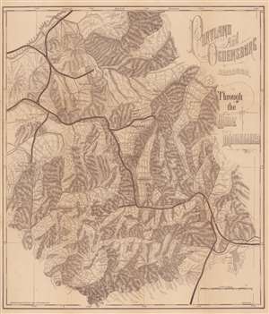
Portland and Ogdensburg Railroad. Through the White Mountains.
sold
- Digital Map Information
- Suitable for large format printing
- File Size: 15.56 MB
- File Type: ZIP / TIFF
- ICC color profile embedded
- Delivered instantly via download link
This is a c. 1880 Frederick Julian Ilsley map of the White Mountains in New Hampshire. Depicting from Lancaster on the Connecticut River south to Conway, the Saco River, and Black Sandwich Dome, thick black lines highlight the Portland and Ogdensburg Railroad's route through the mountains. Roads and rivers are illustrated and mountain peaks are identified. (more details)
Adirondack Express.
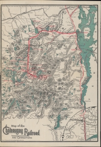
Map of the Chateaugay Railroad and Connections.
sold
- Digital Map Information
- Suitable for large format printing
- File Size: 12.25 MB
- File Type: ZIP / TIFF
- ICC color profile embedded
- Delivered instantly via download link
A c. 1891 map of the Adirondacks region and Lake Champlain tracing the lines of the Chateaugay Railroad, printed by the American Bank Note Co. This map was produced when railroads had opened up the Adirondacks for travelers, making it a fashionable destination for tourists from New York City and other cities in New England and the Mid-Atlantic. (more details)
An extremely rare railroad map of the route between Brooklyn and Boston.
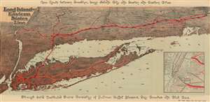
Long Island and Eastern States Line.
sold
- Digital Map Information
- Suitable for large format printing
- File Size: 15.4 MB
- File Type: ZIP / TIFF
- ICC color profile embedded
- Delivered instantly via download link
This is an 1891 American Bank Note Company railroad map of Long Island. The map illustrates railroad connections between Brooklyn, Long Island City, and Boston, along with all the points in between and depicts the region from New Jersey to Boston and from Albany to Staten Island. The railroads are highlighted in red and trace the way from Brooklyn to Boston. The steamer 'Cape Charles' is used for the transfer across Long Island Sound. Trains left Boston and Brooklyn at approximately 11 p.m. nightly and arrived at their respective destinations by 7:30 a.m. the following morning. The map also highlights the entire Long Island Railroad, which extends the length of Long Island from Brooklyn and Long Island City to Greenport and Sag Harbor. Cities and towns throughout the region are labeled, particularly along the rail lines, including Hartford, New Haven, and Providence. Myriad points, necks, bays, and other coastal features are also identified. (more details)
The Southern Railway and the Florida Central and Peninsular Railroad.
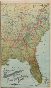
Birds Eye View of the Southern Railway and the Florida Central and Peninsula Systems and Their Connections.
sold
- Digital Map Information
- Suitable for large format printing
- Full resolution TIFF file
- ICC color profile embedded
- Delivered instantly via download link
A rare find, this is the c. 1894 American Bank Note bird's-eye view railroad map of the eastern United States published by the Southern Railway. It cleverly employs the view perspective to focus on the Southern States, particularly Florida, while still showing connections to networks to the north. (more details)
Beautiful chromolithograph map of the New York - Lake George - Lake Champlain - Montreal route.
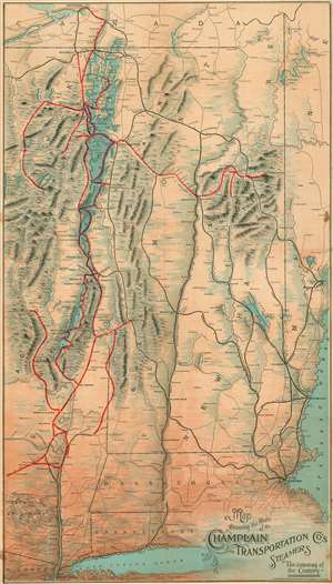
Showing the Route of the Champlain Transportation Co's Steamers. The Gateway of the Country.
sold
- Digital Map Information
- Suitable for large format printing
- File Size: 52 MB
- File Type: ZIP / TIFF
- ICC color profile embedded
- Delivered instantly via download link
A stunning 1898 chromolithograph map illustrating the routes of the Champlain Transportation Company. The map covers the briskly travelled Hudson Valley / Lake Champlain corridor between New York City and Montreal, extending eastward to the Atlantic to include Portland, Portsmouth, and Boston. While the focus of the map are the ferry routes through Lake George and Lake Champlain, the map also illustrates railroad lines operating by the Champlain Transportation Company to various points in the Adirondacks, Green Mountains and White Mountains. Competing but connecting railroad lines appear in black. The mountainous regions are highlighted to suggestive that these destinations are cool summer resorts. (more details)