
Atlanta Service (sold)

Atlanta Service (fl. c. 1945 - 1947), also known as Atlanta GmbH, was a 'company for international advertising for industry, export, and traffic' operating in Frankfurt am Main in the years just after World War II.
Highlights the post-WWII Allied occupation zones in Germany using Germany's 1937 borders.
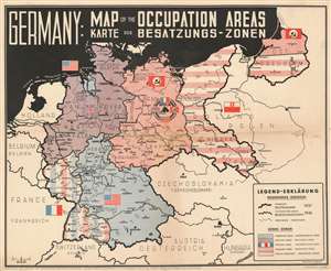
Germany: Map of the Occupied Areas. Karte der Besatzungs-Zonen.
sold
- Digital Map Information
- Suitable for large format printing
- File Size: 18.58 MB
- File Type: ZIP / TIFF
- ICC color profile embedded
- Delivered instantly via download link
This is a bilingual English and German 1945 World War II (WWII) Atlanta Service map of Germany delineating the Allied Occupation Zones after the defeat of Nazi Germany. Germany follows its 1937 borders. The Oder-Neisse Line, the basis for the border between Germany and Poland, is in bold. The four Occupation Zones, administered by the United States, Great Britain, France, and the Soviet Union, are divided and shaded accordingly to allow for easy differentiation. What was formerly Eastern Germany is shaded using red and white stripes to indicate that it was now part of a reconstituted Poland. Berlin is specifically highlighted, because, as it was the capital of defeated Nazi Germany, it was decided that all four Allies would occupy and administer a sector of the city. (more details)
Post-WWII Allied occupation zones.
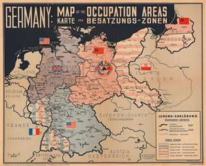
Germany: Map of the Occupied Areas. Karte der Besatzungs-Zonen.
sold
- Digital Map Information
- Suitable for large format printing
- Full resolution TIFF file
- ICC color profile embedded
- Delivered instantly via download link
This is a bilingual English and German 1945 World War II (WWII) Atlanta Service map of Germany delineating the Allied Occupation Zones after the defeat of Nazi Germany. Germany follows its 1937 borders. The Oder-Neisse Line, the basis for the border between Germany and Poland, is in bold. The four Occupation Zones, administered by the United States, Great Britain, France, and the Soviet Union, are divided and shaded. What was formerly Eastern Germany, is coded in red and white stripes where it was merged with a reconstituted Poland. Berlin is specifically highlighted, because, as the capital of defeated Germany, it was decided that all four Allies would occupy and administer a sector of the city. (more details)
Occupied Germany after World War II.
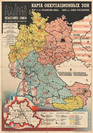
Atlanta Karte der Besatzungs-Zonen mit Neuen Postleitgebieten. КАРТА ОККУПАЦИОННЫХ ЗОН. Map of the Occupation Areas. Carte des Zonesd'Occupation.
sold
- Digital Map Information
- Suitable for large format printing
- File Size: 19.93 MB
- File Type: ZIP / TIFF
- ICC color profile embedded
- Delivered instantly via download link
This is the c. 1946 Atlanta Service map of Germany delineating the Allied Occupation Zones after the defeat of Nazi Germany. Text appears in four different languages: English, Russian, French, and German. The Oder-Neisse Line, the basis for the border between Germany and Poland, is in bold. The four Occupation Zones, administered by the United States, Great Britain, France, and the Soviet Union, are divided and shaded accordingly. Former Eastern Germany is highlighted to indicate that it was now part of a reconstituted Poland, and possibly its allegiance to the Soviet Union. Berlin is specifically highlighted, because, as it was the capital of defeated Nazi Germany, it was decided that all four Allies would occupy and administer a sector of the city. An inset in the lower-left depicts a divided Berlin, illustrating neighborhoods within each zone. (more details)
Occupied Germany after World War II.
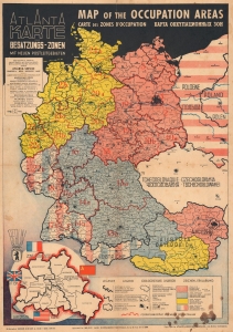
Atlanta Karte der Besatzungs-Zonen mit Neuen Postleitgebieten. Map of the Occupation Areas. Carte des Zones d'Occupation. КАРТА ОККУПАЦИОННЫХ ЗОН.
sold
- Digital Map Information
- Suitable for large format printing
- File Size: 20.98 MB
- File Type: ZIP / TIFF
- ICC color profile embedded
- Delivered instantly via download link
This is a 1946 Atlanta Service map of Germany delineating the Allied Occupation Zones after the defeat of Nazi Germany. (more details)
Occupied Germany after World War II.
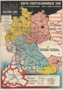
Atlanta Karte der Besatzungs-Zonen mit Neuen Postleitgebieten. КАРТА ОККУПАЦИОННЫХ ЗОН. Map of the Occupation Areas. Carte des Zones d'Occupation.
sold
- Digital Map Information
- Suitable for large format printing
- File Size: 19.87 MB
- File Type: ZIP / TIFF
- ICC color profile embedded
- Delivered instantly via download link
This is the c. 1946 Atlanta Service map of Germany delineating the Allied Occupation Zones after the defeat of Nazi Germany. Text appears in four different languages: English, Russian, French, and German. The Oder-Neisse Line, the basis for the border between Germany and Poland, is in bold. The four Occupation Zones, administered by the United States, Great Britain, France, and the Soviet Union, are divided and shaded accordingly. Former Eastern Germany is highlighted to indicate that it was now part of a reconstituted Poland, and possibly its allegiance to the Soviet Union. Berlin is specifically highlighted, because, as it was the capital of defeated Nazi Germany, it was decided that all four Allies would occupy and administer a sector of the city. An inset in the lower-left depicts a divided Berlin, illustrating neighborhoods within each zone. (more details)
Occupied Germany after World War II.
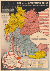
Atlanta Karte der Besatzungs-Zonen mit Neuen Postleitgebieten. Map of the Occupation Areas. Carte des Zones d'Occupation. КАРТА ОККУПАЦИОННЫХ ЗОН.
sold
- Digital Map Information
- Suitable for large format printing
- File Size: 22.91 MB
- File Type: ZIP / TIFF
- ICC color profile embedded
- Delivered instantly via download link
This is a 1946 Atlanta Service map of Germany delineating the Allied Occupation Zones after the defeat of Nazi Germany. (more details)