
Bates, Waldron (sold)

Waldron Bates (November 24, 1856 - February 9, 1909) was an American lawyer, author, cartographer, and avid outdoorsman. Born in Boston, Massachusetts, Bates attended Harvard and graduated in 1879. He then attended Boston University, from which he received a law degree in 1882. In 1892, Bates joined the Bar Harbor Village Improvement Association, and was named its Path Committee Chairman in 1900, a position he held until his death in 1909, and served as the Association's president from 1904-05. Bates, Edward Rand, and Herbert Jaques published the 'Map of Mount Desert Island' and the 'Path Map of the Eastern Part of Mount Desert Island' in 1896. He was well known around Bar Harbor and Mount Desert Island as a pathmaker. He would plan and build trails leading to geologically interesting rock formations and related sites, and also instituted a uniform method of signage for these trails. On February 9, 1909, Bates tragically passed away when he tried to board a train leaving the railroad station in Monroe, Virginia. According to newspaper accounts, Bates was trying to board a Pullman car, when he lost his footing, slipped, and fell under the departing train. He never married.
The last edition of a landmark map in the cartography of Mount Desert Island.
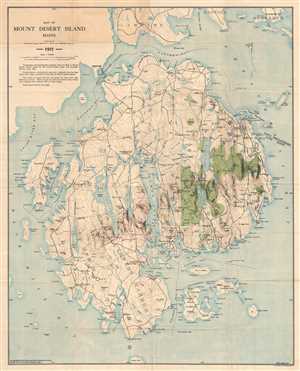
Map of Mount Desert Island Maine.
sold
- Digital Map Information
- Suitable for large format printing
- File Size: 19.96 MB
- File Type: ZIP / TIFF
- ICC color profile embedded
- Delivered instantly via download link
This is a 1911 map of Mount Desert Island, Maine compiled by Waldron Bates, Edward L. Rand, and Herbert Jaques. The map depicts the island from Blue Hill Bay to Frenchman's Bay and from Lamoine, Hancock, and Sorrento to Great Gott Island. Highly detailed, locations throughout the island are labeled, including the towns of Bar Harbor (labeled here as Eden), Mount Desert, Southwest Harbor, and Tremont. Villages throughout each of these towns are also labeled, including Salisbury Cove, Somesville, West Tremont, and Seal Harbor. The topography, illustrating elevation changes in forty-foot intervals, was adapted from the Map of Mount Desert Island issued by the United States Coast and Geodetic Survey in 1882, as was the hydrography.
(more details)
(more details)