
Beaurain, Jean de (sold)

Jean de Beaurain (January 17, 1696 - February 12, 1771) was a French geographer and military historian under Louis XV. He was born in Aix-en-Issart, Pas-de-Calais, and came to Paris in 1715 at age 19, where he studied geography under Pierre Moulart-Sanson (16?? - c. 1721), Géographe du Roi and grandson of Nicolas Sanson (1600 - 1667). Beaurain inherited this same title from Moulart-Sanson in 1721, when he was just 25. He taught geography to Louis XV (1729 - 1765) and received an annual pension of 800 pounds. Beaurain maintained offices on the Quai des Grands-Augustins. He was succeeded by his son, Jean-Baptiste Jacques de Beaurain (1728 - c. 1785).
The site of the first naval engagement of the Seven Years' War.
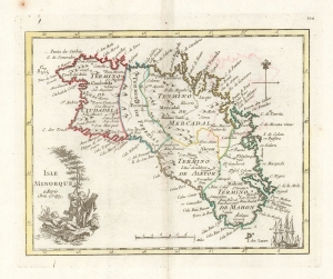
Isle Minorque a paris Chez Crepy.
sold
- Digital Map Information
- Suitable for large format printing
- DPI: 600
- File Size: 9.31 MB
- File Type: ZIP / TIFF
- ICC color profile embedded
- Delivered instantly via download link
This is a handsome, scarce example of George-Louis Le Rouge's 1759 map of Minorca. It was the last of a hundred maps in his Atlas Nouveau Portatif, which compiled an array of maps relevant to the Seven Years' War's European theatres. Minorca, therefore, was an important inclusion, being the site of the opening naval battle of that war in 1756. The map depicts Minorca and its provincial divisions as they stood during Britain's control of the Island, but the map was produced in the immediate aftermath of the battle by which the French ended British rule in Minorca, taking from Britain her primary Mediterranean base and effectively passing control of that sea to the French.
The maps for Le Rouge's Atlas were mainly sourced from those of Homann and Mayer, and the source for this map was published the year after the Battle of Minorca by Homann Heirs. It had been drawn by the French Royal Geographer, Jean de Beaurain; consequently it presented not only the most recent but the most authoritative mapping of the crucial Mediterranean strongpoint. (more details)
The maps for Le Rouge's Atlas were mainly sourced from those of Homann and Mayer, and the source for this map was published the year after the Battle of Minorca by Homann Heirs. It had been drawn by the French Royal Geographer, Jean de Beaurain; consequently it presented not only the most recent but the most authoritative mapping of the crucial Mediterranean strongpoint. (more details)