
Bonner, John (sold)

John Bonner (1643 - January 30, 1726) was a captain, navigator, map-seller and shipwright active in Pre-Revolutionary War Boston. He was admired for his skill in navigation and was considered one of the best pilots in North America. Bonner was married to Mary Clarke Bonner (1665 - 1697), daughter of Elder Jonas Clark of Cambridge. He was survived by his wife and son, also John Bonner. His is best known for producing the first printed map of Boston, in 1722.
19th Century reissue of the earliest Printed Map of Boston.
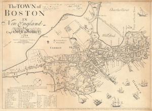
The Town of Boston in New England by Capt. John Bonner 1722.
sold
- Digital Map Information
- Suitable for large format printing
- File Size: 14.26 MB
- File Type: ZIP / TIFF
- ICC color profile embedded
- Delivered instantly via download link
This is George Girdler Smith's rare 1835 reissue of John Bonner's 1722 city map or plan of Boston. Considered the first printed map of Boston, Bonner's map covers the city's location on the Shawmut Peninsula, nearly an island, as it appeared in the early 18th century. (more details)
19th Century reissue of the earliest Printed Map of the City - with distinguished provenance.
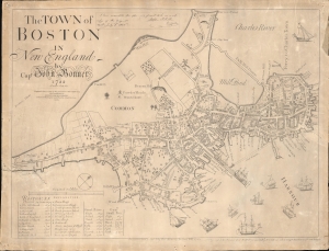
The Town of Boston in New England by Capt. John Bonner 1722.
sold
- Digital Map Information
- Suitable for large format printing
- Full resolution TIFF file
- ICC color profile embedded
- Delivered instantly via download link
An illuminating window into the early history of Boston, this is George Girdler Smith's rare 1835 reissue of John Bonner's 1722 city map or plan of Boston. Considered the first printed map of Boston, Bonner's map covers the city's location on the Shawmut Peninsula, nearly an island, as it appeared in the early 18th century. Distinguished provenance linking the map to Deacon John Price of Manchester, New Hampshire. (more details)
Smith edition of the first printed map of Boston!
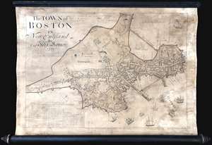
This is George Girdler Smith’s (1795-1878) rare 1835 reissue of John Bonner’s 1722 map of Boston. Considered the first printed map of Boston, Bonner’s map covers the peninsula of Boston as it appeared in the early 18th century. The map includes a wealth of fascinating information about pre-Revolutionary War Boston, including street layouts, the Boston Common, Beacon Hill, the Mill Dam, churches, public buildings, and more. Bonner also illustrates Boston's importance as a port city, detailing the location of docks, shipyards, wharves, and ropewalks. An index in the lower left helps to identify various locales on the map. The harbor around Boston is full of engraved sailing ships – evidence of Boston’s lively trade and prosperity. (more details)