
Bradley Jr., Abraham (sold)

Abraham Bradley, Jr. (February 22, 1767 - May 7, 1838) was an American lawyer, judge, and cartographer who served as assistant postmaster general for 30 years. Bradley was responsible for moving the federal post office from Philadelphia to Washington, D.C. and even hosted the national post office in his home for a period. He was employed under five different U.S. postmasters general and drew detailed and innovative maps of postal routes. Bradley, after having established his private law practice in 1788, briefly served as a county judge. There he became acquainted with Timothy Pickering, who was appointed by President Washington as postmaster general in 1791. Bradley served as his clerk, and began compiling information for a complete postal service map. Bradley's extensive knowledge of the department and the routes made him indispensable when Pickering was succeeded in 1795. Bradley is regarded as an influential figure in the early history of the Post Office. His postal routes and schedules were rigidly enforced for thirty years and gave the department a 'rapid and reliable engine for delivering information across vast distances'.
A very scarce English edition of one of the first American maps to extend to the Mississippi River.
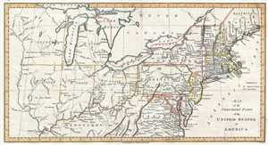
Map of the Northern Part of the United States of America.
sold
- Digital Map Information
- Suitable for large format printing
- DPI: 300
- File Size: 3.04 MB
- File Type: ZIP / TIFF
- ICC color profile embedded
- Delivered instantly via download link
This is a scarce and significant early 1802 postal route map of the northern parts of the United States illustrating postal routes and the five Jeffersonian states proposed by the Ordinance of 1789. The present example is the 1802 Jedidiah Morse issue of the ... (more details)
One of the earliest American maps to extend to the Mississippi. Illustrates ealry postal routes and the Connecticut Western Reserve.
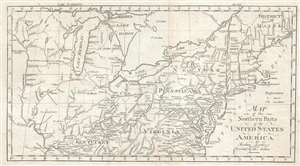
Map of the Northern Pars of the United States of America. By Abraham Bradley Jr. Corrected by the Author.
sold
- Digital Map Information
- Suitable for large format printing
- DPI: 300
- File Size: 3.83 MB
- File Type: ZIP / TIFF
- ICC color profile embedded
- Delivered instantly via download link
This is a scarce and significant early postal route map of the northern parts of the United States illustrating postal routes and the five Jeffersonian states proposed by the Ordinance of 1789. The present example is the 1802 Jedidiah Morse issue of the ... (more details)
One of the earliest American maps to extend to the Mississippi. Illustrates early postal routes and the Connecticut Western Reserve.

Map of the Northern Parts of the United States of America. By Abraham Bradley Jr. Corrected by the Author.
sold
- Digital Map Information
- Suitable for large format printing
- DPI: 300
- File Size: 3.5 MB
- File Type: ZIP / TIFF
- ICC color profile embedded
- Delivered instantly via download link
This is a scarce and significant early 1802 postal route map of the northern parts of the United States illustrating postal routes and the five Jeffersonian states proposed by the Ordinance of 1789. The present example is the 1802 Jedidiah Morse issue ... (more details)
One of the Earliest American Maps to Extend to the Mississippi.
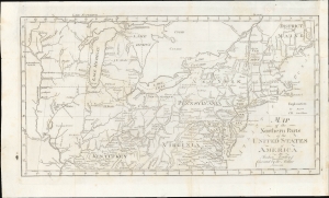
Map of the Northern Parts of the United States of America.
sold
- Digital Map Information
- Suitable for large format printing
- File Size: 196.32 MB
- File Type: ZIP / TIFF
- ICC color profile embedded
- Delivered instantly via download link
This is a significant 1802 map of the northern parts of the United States illustrating postal routes and the five Jeffersonian states proposed by the Ordinance of 1789. The present example is the Jedidiah Morse issue of the northern part of Abraham Bradley's 1797 postal map of the United States - one of the most important maps in American history. It is one of the first American maps to extend west to the Mississippi River, and one of the first to address early colonization of the lands west of Pennsylvania, including Ohio. (more details)