
Bryant y Galiano, Tomás (sold)

Tomás Bryant y Galiano (fl. c. 1858 – 1879) was a Spanish navigator, sea captain, and chart maker active in the second half of the 19th century. Little is known of Bryant's life, but he appears to have been the grandson of a prominent Spanish shipbuilder Eduardo Bryant and son of Tomás Bryant y Smith (1748 – 18??). Bryant is best known for his charts of Spanish-American waters in the Caribbean and South America published by the Dirección de Hidrografía.
South China Sea - then as now, an important and strategic artery.
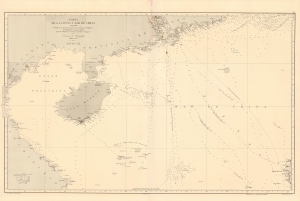
Carta de la Costa y Mar de China comprendida entre el Cabo Batangan y el Canal de Formosa con parte de la Isla de Luzon, segun los trabajos mas recientes macionales y estrangeros.
sold
- Digital Map Information
- Suitable for large format printing
- File Size: 48.36 MB
- File Type: ZIP / TIFF
- ICC color profile embedded
- Delivered instantly via download link
A rare 1869 Direccion Hidrografía nautical map detailing the China coast and the South China Sea from, roughly, Hong Kong and Macao south to Hue (Vietnam) and Luzon (the Philippines), thus embracing a highly-trafficked and critical trade and strategic channel in the 19th century (as today). The map focuses heavily on coastal maritime routes, but pushes inland along major river arteries, including a detailed mapping of the Pearl River Delta as far as Canton (Guangzhou). In Vietnam, several factorias antiguas are noted, underscoring early European trade activity. (more details)