
Chudjakov, Efim Maksimovič (sold)

Efim Maksimovič Chudjakov (1748-1822) was a Russian cartographer and engraver active in the late 18th and early 19th centuries. Based in Saint Petersburg, Chudjakob was affiliated with the Saint Petersburg Academy of Sciences and is recognized for his remarkable and expansive 1776 map of Russia.
St. Petersburg at the end of Catherine the Great's reign.
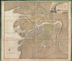
Plan der Kayserlichen Residenz Stadt St. Petersburg.
sold
- Digital Map Information
- Suitable for large format printing
- DPI: 600
- File Size: 18.61 MB
- File Type: ZIP / TIFF
- ICC color profile embedded
- Delivered instantly via download link
This is a 1790 Efim Maksimovič Chudjakov city map or plan of St. Petersburg. The map depicts the city from the Bolshaya Nevka Neva south past the Reka Bol'shaya River and from Neva Bay, also known as the Gulf of Kronstadt, to the Neva River. Highly detailed, over one hundred twenty locations are numerically identified, though unfortunately the corresponding index is not present. The Peter and Paul Fortress is illustrated in detail along the Neva River. (more details)
Two extremely rare maps of St. Petersburg near the end of the reign of Catherine the Great.
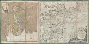
Plan der Kayserlichen Residenz Stadt St. Petersburg. / Charte vom St. Petersburgischen Gouvernement nach dessen jetzigen.
sold
- Digital Map Information
- Suitable for large format printing
- DPI: 300
- File Size: 18.2 MB
- File Type: ZIP / TIFF
- ICC color profile embedded
- Delivered instantly via download link
This is a 1790 Efim Maksimovič Chudjakov city map or plan of St. Petersburg and a 1790 I.D. Schlepper map of the environs of St. Petersburg. The Chudjakov map depicts the city from the Bolshaya Nevka Neva south past the Reka Bol'shaya River and from Neva Bay, also ... (more details)