
Klaudyán, Mikuláš (sold)

Mikuláš Klaudyán (Lat. Nicolas Claudianus, died 1522) was a Bohemian physician and scholar, sometime publisher, and member of the Czech or Bohemian Brethren, a Protestant group formed in 1457 rooted in the teachings of Jan Hus. He printed the oldest map of Bohemia in 1518, hailed by Nordenskjold as 'the first map on which the different religious and political conditions of a country are denoted.'
Earliest map of Czech, earliest map with a key!
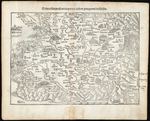
Behmer kunigreich mit bergen und waelden gerings umb beschlossen.
sold
- Digital Map Information
- Suitable for large format printing
- Full resolution TIFF file
- ICC color profile embedded
- Delivered instantly via download link
This is Munster's 1545 map of Bohemia, the earliest acquirable printed map of what is now the Czech Republic. This map appeared in the 1572 Latin edition Munster’s Cosmographia Universalis, a work notable for presenting to a broad lay audience many of the first printed maps based on contemporaneous surveys and toponymy, rather than data from classical sources. Munster’s source for this map was Nicolaus Claudianus’ 1518 map of Bohemia, which now exists in only one known surviving example. Munster's map is the only version of Claudianus' map available to the collector. (more details)
Earliest map of Czech, earliest map with a key!
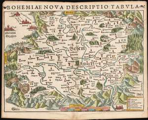
Bohemiae Nova Descriptio Tabula.
sold
- Digital Map Information
- Suitable for large format printing
- Full resolution TIFF file
- ICC color profile embedded
- Delivered instantly via download link
This is Munster's 1545 map of Bohemia, the earliest acquirable printed map of what is now the Czech Republic. This map appeared in the 1572 Latin edition Munster’s Cosmographia Universalis, a work notable for presenting to a broad lay audience many of the first printed maps based on contemporaneous surveys and toponymy, rather than data from classical sources. Munster’s source for this map was Nicolaus Claudianus’ 1518 map of Bohemia, which now exists in only one known surviving example. Munster's map is the only version of Claudianus' map available to the collector. (more details)
Earliest map of Czechia, earliest map with a key!
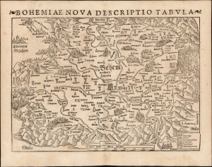
Bohemiae Nova Descriptio Tabula.
sold
- Digital Map Information
- Suitable for large format printing
- Full resolution TIFF file
- ICC color profile embedded
- Delivered instantly via download link
This is Sebastian Münster's 1545 map of Bohemia, the earliest acquirable printed map of what is now the Czech Republic. This example appeared in the 1572 Latin edition of Münster's Cosmographia Universalis, a work notable for presenting to a broad lay audience many of the first printed maps based on contemporaneous surveys and toponymy, rather than data from classical sources. Munster's source for this map was Nicolaus Claudianus' 1518 map of Bohemia, which now exists in only one known surviving example. Munster's map is the only version of Claudianus' map available to the collector. (more details)
The Earliest Acquirable Map of Bohemia, and the First Acquirable Map to Use a Key
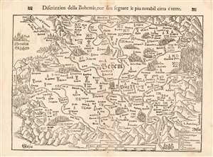
Discrizzion della Bohemia, oue son segnate le piu notabil citta é terre.
sold
- Digital Map Information
- Suitable for large format printing
- DPI: 600
- File Size: 10.23 MB
- File Type: ZIP / TIFF
- ICC color profile embedded
- Delivered instantly via download link
This is Munster's 1545 map of Bohemia, the earliest acquirable printed map of what is now the Czech Republic. The map appeared in an Italian edition of Munster’s Cosmographia Universalis, a work notable for presenting to a broad lay audience many of the first printed maps to rely on recent surveys and toponymy, rather than data from classical sources. Munster’s source for this map was Nicolaus Claudianus’ 1518 map of Bohemia, which now exists in only one known copy. Munster's map is the only version of Claudianus' map available to the collector. (more details)