
Colburn, Henry (sold)

Henry Colburn (1784 - August 16, 1855) was a British publisher. Colburn started off in the publishing profession in the Albemarle Street shop of William Earle, a bookseller in London. His next move was to become an assistant at a circulating library on Conduit Street called Morgan's Library, which he took over in 1816. Eventually he signed this business over to Messrs. Saunders and Otley and opened his own publishing firm. He gained initial success with the roman à clef novel Glenavron by Lady Caroline Lamb and which was published in 1816. It went through four editions and sold well. Colburn later expanded on the success of Glenavron and published a series of so-called 'Silver Fork Novels', a series of books that afforded readers the thrill of peering into the lives of rich and aristocratic families. Colburn also started several periodicals, including the New Monthly Magazine, the Literary Gazette, the earliest weekly newspaper dedicated to literature, science, and the arts. Colburn married twice. His second marriage was to Eliza Anne, who survived him.
Independent Mexico with the province of Texas.
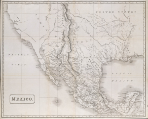
Mexico.
sold
- Digital Map Information
- Suitable for large format printing
- File Size: 2170.02 MB
- File Type: ZIP / TIFF
- ICC color profile embedded
- Delivered instantly via download link
This is an 1828 Henry Coburn map of Mexico, issued just a few years after Mexican Independence (1821) and a few years before the Texan Revolution (1835 - 1836). Published in Britain, this map highlights British interest, mostly investment-driven, in the ongoing Mexican fight for independence, as well as Austin's Town (Austin, Texas), reflecting the growing Anglo-American presence in Texas. (more details)
First published view of Singapore.
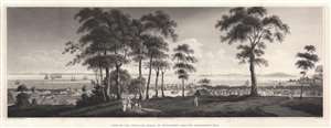
View of the Town and Roads of Singapore from the Government Hill.
sold
- Digital Map Information
- Suitable for large format printing
- Full resolution TIFF file
- ICC color profile embedded
- Delivered instantly via download link
The first printed view of Singapore, issued less than 10 years after it was founded by Sir Thomas Stamford Raffles (1781 - 1826). This aquatint view was published in 1828 after a painting by Royal Navy Captain Robert James Elliot. It looks on Singapore from Government Hill, covering the Plain, Singapore River, and Chinatown. Even at this early stage, presents a bustling city with numerous buildings and a lively port. We have not been able to trance Elliot's original painting. (more details)
First published plan of Singapore.
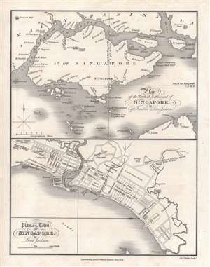
Plan of the Town of Singapore by Lieut. Jackson. / Plan of the British Settlement of Singapore by Capt. Franklin and Lieut. Jackson.
sold
- Digital Map Information
- Suitable for large format printing
- Full resolution TIFF file
- ICC color profile embedded
- Delivered instantly via download link
Known as the Jackson Plan or Raffles Plan, this is the first published map of Singapore. Published in 1828, the map was drawn by Lieutenant Philip Jackson at the request of Singapore founder Sir Stamford Raffles (1781 - 1826). It is divided into two sections, a map of the island of Singapore, and a close-up plan of the town of Singapore. The city plan presents an idealized version of Singapore following the Raffles vision and, while not fully implemented, was influential in the early development of the colony. (more details)
First published plan of Singapore.
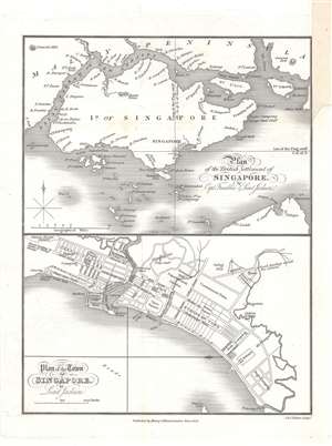
Plan of the Town of Singapore by Lieut. Jackson. / Plan of the British Settlement of Singapore by Capt. Franklin and Lieut. Jackson.
sold
- Digital Map Information
- Suitable for large format printing
- DPI: 600
- File Size: 9.23 MB
- File Type: ZIP / TIFF
- ICC color profile embedded
- Delivered instantly via download link
Known as the Jackson Plan or Raffles Plan, this is the first published map of Singapore. Published in 1828, the map was drawn by Lieutenant Philip Jackson at the request of the founder of modern Singapore, Sir Stamford Raffles (1781 - 1826). It is divided into two sections, a map of the island of Singapore at top, and a close-up plan of the town of Singapore at bottom, oriented towards the west. The city plan presents an idealized version of Singapore following the Raffles vision and, while not fully implemented, was influential in the early development of the colony. (more details)
Earliest known map of Bangkok.
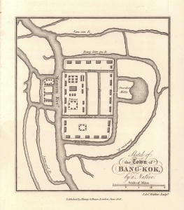
Sketch of the Town of Bang-Kok, by a Native.
sold
- Digital Map Information
- Suitable for large format printing
- Full resolution TIFF file
- ICC color profile embedded
- Delivered instantly via download link
This is the earliest known map of Bangkok, Thailand, issued in 1828, shortly after John Crawfurd's diplomatic mission to the royal court of Siam. The map itself purports to be 'by a native' and was likely drawn for Crawfurd in 1822 when he visited. The map is oriented to the north, with the Royal Palace and temple complex at the center. The Chao Phraya River is identified here by the archaic name Manam. The area covered roughly corresponds to the modern-day Grand Palace and Wat Pho complex. The Powder Mills at the right of the palace are today Saranrom. Some English terminology is used, but waterway names are anglicized Thai. (more details)