
Elzevir (sold)

The house of Elzevir (active c. 1600 - 1712) were a celebrated family of Dutch booksellers, publishers, and printers of the 17th and early 18th centuries; their specialty tended to be small - format 'duodecimo' books. The firm came to prominence with the work of Lodweijk, or Louis, Elzevir (1546-1617) who got his start as a bookbinder in Leuven and after some years became a bookseller and publisher in is own right in Leiden. Louis published about 150 works during his lifetime. He had seven sons, five of whom carried on their father's trade. Of these, Bonaventura Elzevir (1583–1652) is the most celebrated. He began publishing in 1608, joined in 1626 by his nephew Abraham Elzevir (1592-1652). In 1617 another nephew, Isaac Elzevir (1596–1651), acquired a press allowing the family business to take over the production end of the publishing process. Abraham's son Jean Elzevir (1622-1661) joined the partnership in 1647; he would carry on the Leiden business until his death in 1661. Jean's wife, Eva van Alphen Elzevier (active 1651-1663; died 1681) then became head of the business, producing work of a very high quality. Bonaventura's son Daniel. (1626-80) would join his cousin Louis' press in Amsterdam in 1654, but many of their productions were actually manufactured at Eva's press in Leyden. It is likely that the quality work of this period can be credited to her: it dropped sharply after her death in 1681, at which point the business fell into the hands of her feckless son Abraham, whose incompetence brought the company to an end with his own death in 1712.
Ancient and modern directional names explained.
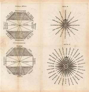
[Untitled diagrams of Compass Roses, Naming the Cardinal Directions.]
sold
- Digital Map Information
- Suitable for large format printing
- Full resolution TIFF file
- ICC color profile embedded
- Delivered instantly via download link
This is an attractively-engraved plate comparing four different conventions in naming the cardinal directions. It was printed in a 1661 Elzevir edition of Philipp Cluver's introduction to geography. Cluver's work appeared in editions by several different houses, and with maps of wildly differing characteristics. Presented here are four separate diagrams, each exemplifying a different, common convention for directional toponomy. (more details)
Attractively Engraved Map of the Northern Part of Europe.
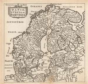
Dania, Suecia et Norvegia.
sold
- Digital Map Information
- Suitable for large format printing
- Full resolution TIFF file
- ICC color profile embedded
- Delivered instantly via download link
This is a finely-engraved miniature map of Scandinavia, printed in a 1661 Elzevir edition of Philipp Cluver's introduction to geography, appearing in editions produced by many different houses, and with maps of wildly differing characteristics. This map follows the model of Swedish mathematician and cartographer Anders Bure, whose 1624 map of Scandinavia - the first geodetically correct map of the region - provided the basis for virtually every general map of the region, including those by Goos, Hondius, and Blaeu, from whose work this one is almost certainly derived. (more details)