
Ensign, Timothy (sold)

Timothy Ensign (September 29, 1795 - September 16, 1849) was a map publisher based in Hartford, Connecticut, active in the early to mid-19th century. Early in his career, Timothy Ensign worked closely with the Hartford both D. W. Kellogg (1836 - 1841) and E. B. and E. C. Kellogg (1842 - 1848). From 1835, he also partnered with his son, Edward Hooker Ensign (1818 - 1871), and Horace Thayer (1811 - 1875) under the imprint of 'Ensigns and Thayer', until his untimely death in 1849 - after which the firm was renamed in the singular, 'Ensign and Thayer'.
Manifest Destiny.
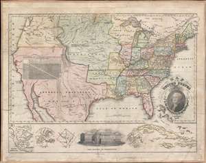
Map of the United States Compiled from the most Authentic Sources.
sold
- Digital Map Information
- Suitable for large format printing
- Full resolution TIFF file
- ICC color profile embedded
- Delivered instantly via download link
This is Timothy Ensign's 1829 map of the United States - one of the earliest to illustrate the United States stretching to the Pacific. Generally known as the 'Washington Map' for the portrait of George Washington in the lower right, Ensign's map covers the United States from Oregon to the Atlantic and from Canada to Mexico. As this map predates the Texas Revolution, the Mexican American War, and the 1846 Treaty of Guadeloupe-Hidalgo, all of the southwest, including California, Arizona, New Mexico, Nevada, Utah, and Texas are part of Mexico. (more details)
On the cusp of the Westward Expansion.
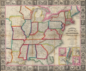
Phelps’s National Map of the United States, A Travellers Guide. Embracing the Principal Rail Roads, Canals, Steam Boat and Stage Routes throughout the Union.
sold
- Digital Map Information
- Suitable for large format printing
- DPI: 600
- File Size: 45.75 MB
- File Type: ZIP / TIFF
- ICC color profile embedded
- Delivered instantly via download link
This is the 1848 issue of the first state of Phelps's map of the United States. The map was issued during the Mexican-American War (1846 - 1848), and as such captures an ephemeral moment in American history: after Texas joined the Union, but before the Treaty of Guadeloupe-Hidalgo and the annexation of Upper California. (more details)