
Fanning, Thomas Colt (sold)

Thomas Colt Fanning (August 2, 1805 - November 21, 1873) was a New York based map publisher active in the middle part of the 19th century. Fanning was born in Norwich, Connecticut. As a young man he apprenticed at a drugstore in Rochester, New York. When he reached his maturity, he relocated to Albion, New York, where he opened the town's first drugstore. He sold this business in 1849 to move to Brooklyn and enter the map publishing business. He initially partnered with Humphrey Phelps (1799 - 1875) and Thomas C. Fanning (1805 - 1873), joining the firm of 'Phelps and Fanning' as a junior partner. From 1854 to 1863 he partnered with Edward H. Ensign (1818 - 1871) and Erastus Clark Bridgman (1817 - 1870), publishing as 'Ensign, Bridgman and Fanning.'
Modestly sized wall map illustrating the westward expansion.
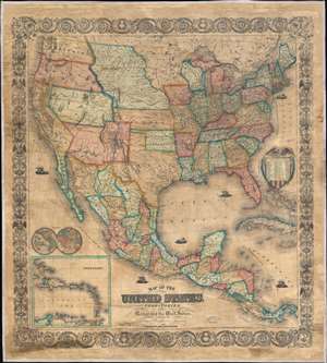
Map of the United States, with its Territories; also Mexico and the West Indies.
sold
- Digital Map Information
- Suitable for large format printing
- File Size: 120.99 MB
- File Type: ZIP / TIFF
- ICC color profile embedded
- Delivered instantly via download link
A scarce American wall map of the United States and Mexico issued by Ensign, Bridgeman and Fanning in 1856. As the title suggests, the map covers all of the United States as well Mexico, Cuba, and Central America as far as Panama. Inset maps in the lower left illustrate the world and the Lesser Antilles. The focus of the map is westward expansion in the United States. Updates accordingly focused in administrative changes west of the Mississippi. Here, Texas configures to the Compromise of 1850 borders and the Gadsden Purchase has added new territory to New Mexico. The borders of Kansas and Nebraska adhere to the Kansas-Nebraska Act of May 30, 1854 in which Nebraska stretches to the Canadian border. The gold region in the Sacramento Valley is highlighted in California. The map noes emigrant and exploration routes to the west, including Fremont's Route, The Oregon Trail, and the Santa Fe Caravan route. American Indian lands are rigorously identified throughout, as if to remind emigrants that the land is not completely free and uninhabited. (more details)
The early days of Minnesota Territory.
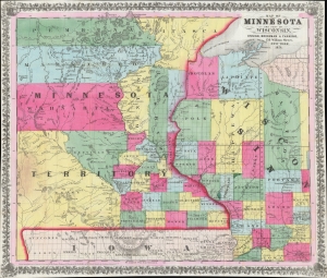
Map of Minnesota and Part of Wisconsin.
sold
- Digital Map Information
- Suitable for large format printing
- Full resolution TIFF file
- ICC color profile embedded
- Delivered instantly via download link
A stunning 1856 Ensign, Bridgman, and Fanning map of Minnesota Territory representing the early settlement of Minnesota. This map illustrates the beginning of the settlement plan for Minnesota proposed by Jonathan Carver in his 1778 Travels. When this map was issued, life in Minnesota was characterized by harsh living conditions and frontier lawlessness dominated by American Indian relations and the fur trade. (more details)
Pedagogical tool - The Empire of Things.
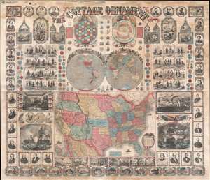
The Cottage Ornament.
sold
- Digital Map Information
- Suitable for large format printing
- File Size: 145.31 MB
- File Type: ZIP / TIFF
- ICC color profile embedded
- Delivered instantly via download link
An impressive pedagogical tool, this is Ensign, Bridgman and Fanning's 1857 wall map of the United States with a densely informative surround. The complex and dense wall map was designed to address pedagogical issues of the mid-19th century, when the westward expansion and homesteading led to increased rural populations without access to educational infrastructure. It is intended to be a textbook at-a-glance, able teach American history, science, and geography, as well as inspire patriotic optimism. The overall organization and pictorial richness mean the reader need not even be literate to absorb the map's messages. (more details)