
Habersham, Robert Alexander (sold)

Robert Alexander Habersham (September 7, 1838 - April 15, 1921) was a civil and military engineer active in Washington and Oregon in the mid to late 19th century. Habersham was born in Habersham County, Georgia (named after his ancestors), where he was a descendent of Revolutionary War veteran James Habersham. It is unclear where he was educated as an engineer, but he worked as an engineer in Brazil on the Dom Pedro II railroad, during which time he met and married Mariquinha Dos Reis. In the 1870s he was in the U.S. Army, serving as an engineer with the rank of 2nd Lieutenant in the 1st Cavalry. He worked in the Portland Office of the Army Corps of Engineers, achieving the rank of general. From 1896, he served two terms as United States Surveyor General of Oregon. Among his more notable work was the 1874 survey of the Cascades of the Columbia River, for which he served as chief of the party. Later in life (after 1914), Habersham relocated to his wife's hometown in Brazil. He died in São Paulo, Brazil, in 1921 and is buried in the Araça cemetery. He is known for detailed and significant maps of Oregon, Washington, and Alaska.
Manuscript record of an egregious (and successful) Swamp Act land grab.
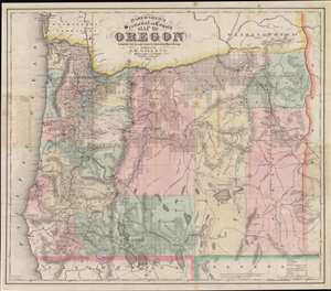
Habersham's Sectional and County Map of Oregon.
sold
- Digital Map Information
- Suitable for large format printing
- File Size: 50.36 MB
- File Type: ZIP / TIFF
- ICC color profile embedded
- Delivered instantly via download link
This 1874 Gill / Habersham map of Oregon is one of the earliest and best separate issue maps of Oregon, here amended with meticulous manuscript annotations illustrating one of the largest and most egregious land grabs in Oregon history. Moreover, the manuscript annotations also bring to light the impact of the little-known Swamp Lands Act on eastern Oregon. (more details)
'... one of the first and best maps that show both Oregon and Washington together, in a large scale, published as a separate' - Rumsey
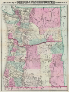
J.K. Gill and Cos. Map of Oregon and Washington Ter.
sold
- Digital Map Information
- Suitable for large format printing
- Full resolution TIFF file
- ICC color profile embedded
- Delivered instantly via download link
This is the 1878 Robert Habersham and John Gill map of Oregon and Washington Territory. It was issued during Washington's early push for statehood. According to David Rumsey, 'this is one of the first and best maps that show both Oregon and Washington together, in a large scale, published as a separate'. The present example has provenance connecting it to Jacob Kamm, co-founder of the Oregon Steam Navigation Company. (more details)