
Hickmann, Anton Leo
Triumph of data visualization.
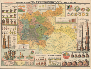
Prof. A. L. Hickmann’s geogr.-statist. Darstellungen über die Bier- und Wein-Produktion im Deutschen Reiche und in Österreich-Ungarn.
$2,500.00
Acquire
- Digital Map Information
- Suitable for large format printing
- Full resolution TIFF file
- ICC color profile embedded
- Delivered instantly via download link
This is Anton Leo Hickmann's c. 1897 colorful chromolithograph statistical map of beer and wine production in the German Empire and Austria-Hungary, published by G. Freytag and Berndt in Vienna. A noted master of the infographic, Hickmann turns the objects of drinking and brewing into instruments of comparison: casks measure trade, towers of barrels rank national output, and elaborate steins compare consumption. The central map provides a complementary geography of drinking, locating breweries and coloring regions according to annual per-capita beer consumption. Published during the industrial expansion of brewing and the phylloxera crisis in European vineyards, the sheet brings two industries undergoing markedly different transformations into a single comparative display. (more details)