
Jewett, John Punchard (sold)
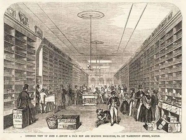
John Punchard Jewett (August 16, 1814 - May 14, 1884) was an American publisher and abolitionist active in Boston in the middle part of the 19th century. Jewett was born in Lebanon, Maine. As a young map he moved to Salem, Massachusetts where he worked in a bookshop and bindery. Jewett grew up in the business, eventually becoming a partner. Around 1849, Jewett relocated the firm to Boston. From at least 1835, Hewett was extremely active in anti-slavery efforts, publishing widely, and joining the first Anti-Slavery Society in New England. He was the published of Harriet Beecher Stowe's classic Uncle Tom's Cabin and Maria S. Cummins's Lamplightser. He published few maps, his most famous being a map of Eastern Kansas during the 'Bloody Kansas' period. His interests were hit hard in the Panic of 1857 and he lost his property, closing his firm. He then traveled to Europe in 1873, developing an interest in early safety matches, or as they were then known, Lucifers. On his return to the United States, he built a match factory in Roxbury, Massachusetts. Meeting with some success, he moved to the larger city of New York in 1867. He lived for an unspecified time before moving to Orange, New Jersey, where he lived out the remainder of his days.
Bleeding Kansas map issued just one month after the Sack of Lawrence.
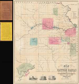
Map of Eastern Kansas.
sold
- Digital Map Information
- Suitable for large format printing
- File Size: 24.02 MB
- File Type: ZIP / TIFF
- ICC color profile embedded
- Delivered instantly via download link
An iconic and historically important map of Eastern Kansas during the 'Free Soil' and 'Bleeding Kansas' or 'Bloody Kansas' era, published just one month after the Sacking of Lawrence. This rare and important 1856 map by the prominent abolitionists Albert D. Searle, Edmund Burke Whitman, and John Punchard Jewett covers the eastern part of Kansas from the 6th Principal Meridian or 97° 22' 08'' W to the Missouri Border and the Missouri River, and from Nebraska to, roughly, the modern day northern border of Oklahoma. The map is intended to promote 'free state' emigration to Kansas as counterbalance to a similar effort by 'slave states' to move their own settlers into the territory. Zones highlighted with color reference American Indian lands - suggesting that emigrants avoid these territories and settle away from 'Indian troubles.' In the lower left there is an inset of Fort Riley on the Missouri River, identified as the 'Geographical Center of U. S. Possessions.' At the base are vignette illustrations of Constitution Hall in Topeka, and before and after images of Eldridge House, also known as the 'Free State Hotel,' which was burned to the ground by pro-slavery vigilantes. (more details)