
Kellogg, Edwin Hosmer (sold)

Edwin Hosmer Kellogg (September 7, 1845 - November 18, 1927) was a civil engineer, surveyor, and map publisher active in Denver, Colorado in the second half of the 19th century. Kellogg was born in White Pigeon, Michigan, but he grew up in Ann Arbor. From 1862 - 1864, he studied from the University of Michigan, but is listed as a non-graduating alumni. He relocated to Denver, Colorado in 1865 to take work as the private secretary to Governor Alexander Cameron Hunt. When Hunt's term ended in 1869, Kellogg began to work privately. Around 1871, he began advertising himself in Denver directories as a civil engineer and surveyor. He appears in Denver directories from 1871 - 1875. During this time he released several important maps of Denver and Colorado in partnership with fellow surveyor Joseph Hartshorne Bonsall (1833 - 1876). Subsequently, he traveled extensively throughout the southwest, pioneering hydraulic engineering in Texas, New Mexico, and Idaho. He moved to San Bernardino, California in 1904 to work as chief engineer of the Arrowhead Reservoir and Power Company. Kellogg died in San Bernardino in 1927.
The most detailed general map of Colorado's central mining regions published in the 1870s.
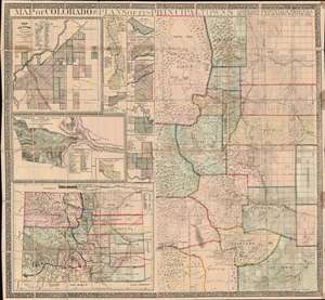
Map of Colorado with Plans of its Principal Towns.
sold
- Digital Map Information
- Suitable for large format printing
- File Size: 95.31 MB
- File Type: ZIP / TIFF
- ICC color profile embedded
- Delivered instantly via download link
A dramatic large-scale 1872 Joseph Hartshorne Bonsall and Edwin Hosmer Kellogg folding wall map of Colorado, issued during the heady days between the Colorado Gold Rush (1859) and the Colorado Silver Boom (1878). This piece is highly significant both for its extreme rarity and for the fact it offers unprecedented detail. Surpassing the Gilpen-Ebert series, the map illustrates maintained trails, and identifies ranches, springs, military reservations, post offices, and more. We are aware of no earlier map, nor any other map issued in the subsequent 10 years, that offers greater detail. (more details)