
Kemble, William (sold)

William Kemble (1813 - c. 1870) was a New York City based merchant and engraver active in the middle part of the 19th century. Kemble immigrated with his wife Sarah from England to the United States on December 31, 1843 on board the ship Passmoz. He settled in New York where he established himself as an artist, merchant, publisher, inventor, and engraver. Kemble was on the 1839 management committee of the American Art Union, a now defunct organization focused on promoting subscription based sales of American art. He was also a founding member of the Century Club, an arts club that included John G. Chapman, a well-known painter, among others. Kemble is buried in Cyprus Hills Cemetery.
Map showing land grants in the Republic of Texas in the year of its founding.
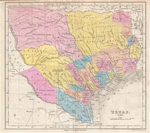
Texas in 1836.
sold
- Digital Map Information
- Suitable for large format printing
- Full resolution TIFF file
- ICC color profile embedded
- Delivered instantly via download link
This is a rare William Kemble map depicting Texas in 1836, shortly after the Convention of 1836 where Texas declared its independence from Mexico and established the Republic of Texas. The map identifies numerous early colonization grants as well as varies new ... (more details)
Failed Bid to Expand the Republic of Texas.
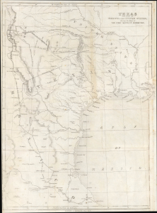
Texas and part of Mexico and the United States showing the route of the first Santa Fé expedition.
sold
- Digital Map Information
- Suitable for large format printing
- File Size: 7.48 MB
- File Type: ZIP / TIFF
- ICC color profile embedded
- Delivered instantly via download link
This is William Kemble's c. 1844 map of the Republic of Texas and Mexico, tracing the failed 1841 Texan Santa Fe Expedition, an important episode in the lead-up to Texas' annexation into the United States in 1845. (more details)
Illustrates English, French, and Spanish possessions in the modern-day United States.
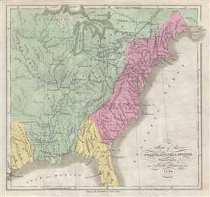
Map of the French, English, and Spanish Possessions in North America in 1745.
sold
- Digital Map Information
- Suitable for large format printing
- DPI: 300
- File Size: 1.64 MB
- File Type: ZIP / TIFF
- ICC color profile embedded
- Delivered instantly via download link
This is an 1846 William Kemble map of the colonial United States. The map depicts the United States from the Missouri River to the Atlantic Ocean and Acadia and from Lake Superior to the Gulf of Mexico. The colonial possessions of the English, French, and ... (more details)
The mission after which Sault Ste. Marie, Michigan is labeled!
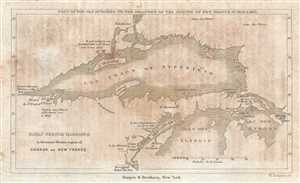
Early French Missions in the remote Western regions of Canada or New France. Copy of the Map Attached to the Relations of the Jesuits in New France in 1670 and 1671.
sold
- Digital Map Information
- Suitable for large format printing
- DPI: 300
- File Size: 0.76 MB
- File Type: ZIP / TIFF
- ICC color profile embedded
- Delivered instantly via download link
This is an 1846 William Kemble map of the region surrounding Lake Superior and the northern portion of Lake Michigan. The map depicts the region from modern-day Minnesota and Wisconsin to Michigan, Lake Huron, and Canada and from Canada and Minnesota to ... (more details)