
Isaac Don Levine (sold)

Isaac Don Levine (January 19, 1892 – February 15, 1981) was an American journalist. Born in Russia, Levine came to the United States in 1911. After finishing high school in Missouri, he began working for The Kansas City Star and then The New York Herald Tribune. He covered the Russian Revolution of 1917 for the Tribune and the Russian Civil War in the 1920s for The Chicago Daily News. He was a columnist for the papers of Hearst papers during the 1920s and 1930s. In 1939, Levine collaborated with famed defector Walter Krivitsky, a chief of military intelligence. Levine was the ghostwriter for a series of articles penned by Krivitsky about Stalinist Russia and his escape. Levine served the editor of Plain Talk, an anti-Communist magazine, from 1945-1950. He also played a role in the case against Alger Hiss, a State Department employee, who stood accused of being a Communist courier.
Rare French edition of what has been cited as 'one of the most important pieces of anti-Communist literature'.
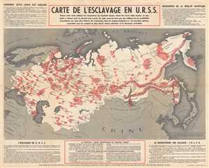
Carte de l'Esclavage en U.R.S.S.
sold
- Digital Map Information
- Suitable for large format printing
- File Size: 13.24 MB
- File Type: ZIP / TIFF
- ICC color profile embedded
- Delivered instantly via download link
Originally published in 1951, this is a French example of what has been cited as 'one of the most widely circulated pieces of anti-Communist literature.' The map depicts the Gulag system of forced labor camps in the Union of Soviet Socialist Republics (U.S.S.R). ... (more details)
The Gulag Archipelago.
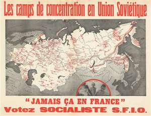
Les camps de concentration en Union Soviétique. 'Jamais ça en France'. Votez Socialiste S.F.I.O.
sold
- Digital Map Information
- Suitable for large format printing
- File Size: 48.45 MB
- File Type: ZIP / TIFF
- ICC color profile embedded
- Delivered instantly via download link
This is a c. 1951 Section française de l'Internationale ouvrière (French Section of the Workers' International) campaign propaganda poster of the Gulag labor and prison camp network in the Soviet Union. The map depicts the Soviet Union from the Baltic Sea to the Bering Strait, highlighting in red the location and extent of the Soviet Russian forced labor camps. The Soviet hammer and sickle mark locally administered camps, while the red dots mark camps under centralized control. The lighter red shades broader forced labor regions. (more details)
The Gulag Archipelago, Revealed
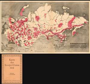
Die Sklavenprovinzen der Sowjetunion: Mit Sternen die Konzentrationdlager lokaler MWD-Behörden bezeichnet; mit Punkten die Zentralen der Zwangsarbeitsgebiete, die grosse Komplexe verschiedener Anlagen umfassen.
sold
- Digital Map Information
- Suitable for large format printing
- File Size: 22.49 MB
- File Type: ZIP / TIFF
- ICC color profile embedded
- Delivered instantly via download link
This is a rare Cold War artifact: a U.S. Information Service persuasive map published in Vienna showing what Russian writer and historian Aleksandr Solzhenitsyn would later call The Gulag Archipelago. This folding, two-color map shows the Soviet Union from the Baltic Sea to the Bering Strait, highlighting in red 'the location and extent of the Soviet Russian forced labor camps...' The German text on the inside cover explains, 'Taken together, these areas would make up a space the size of Western Europe.' Though the first 'corrective labor camps' were established as early as 1918, the full extent of the Gulag's massive prison and forced labor system - as displayed here on the map - was not realized until Stalin's rise to power. The map marks with stars the locations of concentration camps run by the MWD (Ministry of the Interior.) Broader forced labor regions are shaded a light red, with their headquarters locations marked with points. Several such 'forced labor areas' are shown to be linked together by railways, reflecting a high degree of organization and mechanization. (more details)