
Lodewijcksz, Willem (sold) (Lodewycksz, Lodewijksz)
Willem Lodewijcksz (c. 1570 - April 1604) was a Dutch merchant, voyage chronicler, and cartographer associated with Amsterdam and the first Dutch expedition to the East Indies in 1595 - 1597. His birthplace, education, and family circumstances have not been established. Already experienced in seafaring, he joined Cornelis de Houtman's (1565 - 1599) expedition as an assistant merchant aboard the Amsterdam. During the voyage, he undertook reconnaissance, recorded nautical observations, and prepared coastal views, gathering information particularly valuable for mapping the Sunda Strait, northern Java, and Bali. After the fleet returned to the Netherlands in August 1597, the Amsterdam publisher Cornelis Claesz issued his illustrated account as D'Eerste Boeck. Historie van Indien in 1598, with French and Latin translations appearing in the same year. Its cartographic material included coastal profiles, plans of Banten and its harbor, and a separate representation of Bali. Lodewijcksz also compiled a larger regional chart, engraved by Baptista van Doetecum and published separately by Claesz in 1598, covering southern Malaya, Sumatra, southern Borneo, Java, Bali, and neighboring islands. Combining information gathered during the expedition with earlier geographical knowledge, it substantially increased the detail available in print for western and northern Java and the approaches to the Sunda Strait. Although the voyage account announced a chart of Java and Sumatra, that chart is absent from the known editions. Its omission is often attributed to the expedition's merchant backers' desire to restrict commercially sensitive information, although the precise circumstances remain uncertain. Surviving impressions of the separately published regional chart include copies bearing printed sailing directions on the reverse, suggesting its intended practical use rather than proving use at sea. Lodewijcksz's subsequent career remains obscure; he died in April 1604.
AKA: Lodewycksz, Lodewijksz
Revealing Dutch Secrets in the East.
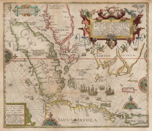
Nova Tabula Insularum Javae, Sumatrae, Borneonis et Aliarum Mallaccam usquae delineate in insula Iava...
sold
- Digital Map Information
- Suitable for large format printing
- DPI: 600
- File Size: 34.83 MB
- File Type: ZIP / TIFF
- ICC color profile embedded
- Delivered instantly via download link
This scarce, beautiful map of the East Indies is Theodore De Bry's 1598 edition of the suppressed work of Cornelis Claesz and Willem Lodewijcksz. The map represents the first Dutch voyage to the Spice Islands and thus the dawn of the Dutch ascendency as a global trade powerhouse. It is also among the earliest printed maps to include Bali. (more details)