
Mathew, Felton (sold)

Felton Mathew (1801 - November 26, 1847) was a British surveyor active in New Zealand during the early colonial period. Felton was born in London. Little is known of his early education and upbringing, but he moved to New South Wales in 1829 to work as Assistant-Surveyor of Roads and Bridges. In 1836, the Colonial Office appointed him as official Sydney Town Surveyor. This position that was voided in 1839, when the Colonial Office determined that Australian states would thereafter manager their own affairs. Without work, Mathew took up an offer to become the first Surveyor-General of New Zealand. There, he completed several important surveys laying out the city plans for Auckland and Wellington. Mathews returned to England in 1845, and again in 1847. On this last trip he fell ill and disembarked in Lima, Peru, where he succumbed to his illness and died.
The earliest obtainable map of Wellington, capital of New Zealand. Shows Maori land grants.
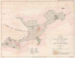
Plan of the City of Wellington Port Nicholson the First and Principal Settlement of the New Zealand Company.
sold
- Digital Map Information
- Suitable for large format printing
- DPI: 300
- File Size: 9.17 MB
- File Type: ZIP / TIFF
- ICC color profile embedded
- Delivered instantly via download link
This rare 1841 map of Wellington is one of the earliest obtainable plans of the modern-day capital of New Zealand. The map was surveyed on behalf of the New Zealand Land Company in 1840 by the first Surveyor-General of New Zealand, Felton Mathew. Mathew laid out the new city's road and grid system in precise detail. The street grid shown here is still reflected in the modern city. This map was issued in 1842 for the House of Commons, probably in conjunction with the Spain Commission, and based upon Mathew's 1840 manuscript survey. (more details)