
Moss, Ira (sold)

Ira Moss (fl. c. 1954 - 1956) was an American painter and graphic designer active in New York City during the mid-20th century. His corpus includes pictorial maps of New York City as well as national 'fish and game' maps.
An eye-catching and comical pictorial map of Manhattan.
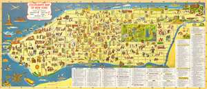
Colorgraph Map of New York.
sold
- Digital Map Information
- Suitable for large format printing
- File Size: 47.31 MB
- File Type: ZIP / TIFF
- ICC color profile embedded
- Delivered instantly via download link
This is a first edition 1954 Ira Moss pictorial map of the borough of Manhattan in New York City. Eye-catching and entertaining, 197 different locations throughout Manhattan are illustrated as vignettes and identified numerically. These numbers then correspond to an index situated along the bottom and right side listing the sites by category, including hotels, restaurants, night clubs, churches, bridges, stores, 'points of educational interest' (museums, libraries, universities, etc), and other points of interest.
Sites such as the Empire State Building, the Chrysler Building, the Washington Square Arch, and the Brooklyn Bridge, along with numerous hotels, including the Waldorf-Astoria, are illustrated in profile. Other sites are marked by representative illustrations. The American Museum of Natural History, for example, is highlighted by a tourist being chased by a Tyrannosaurus Rex skeleton, and the Central Park Zoo is noted by an elephant being fed by a small child. Some of the illustrations are not numbered and go unidentified, most of which are ships and boats of varying size in the Hudson and East Rivers. At the same time, the Lincoln Tunnel, Queens Midtown Tunnel, and Holland Tunnel are all illustrated and labeled, as is the Washington Market. (more details)
Sites such as the Empire State Building, the Chrysler Building, the Washington Square Arch, and the Brooklyn Bridge, along with numerous hotels, including the Waldorf-Astoria, are illustrated in profile. Other sites are marked by representative illustrations. The American Museum of Natural History, for example, is highlighted by a tourist being chased by a Tyrannosaurus Rex skeleton, and the Central Park Zoo is noted by an elephant being fed by a small child. Some of the illustrations are not numbered and go unidentified, most of which are ships and boats of varying size in the Hudson and East Rivers. At the same time, the Lincoln Tunnel, Queens Midtown Tunnel, and Holland Tunnel are all illustrated and labeled, as is the Washington Market. (more details)
Eye-catching and comical Manhattan.
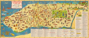
This is a first edition 1954 Ira Moss pictorial map of the borough of Manhattan in New York City. Eye-catching and entertaining, 197 different locations throughout Manhattan are illustrated as vignettes and numerically identified. These numbers correspond to an index along the bottom and right listing the sites by category, including hotels, restaurants, night clubs, churches, bridges, stores, 'points of educational interest' (museums, libraries, universities, etc.), and other points of interest. (more details)
Eye-catching and comical Manhattan.
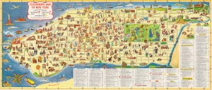
This is a first edition 1954 Ira Moss pictorial map of the borough of Manhattan in New York City. Eye-catching and entertaining, 197 different locations throughout Manhattan are illustrated as vignettes and numerically identified. These numbers correspond to an index along the bottom and right listing the sites by category, including hotels, restaurants, night clubs, churches, bridges, stores, 'points of educational interest' (museums, libraries, universities, etc.), and other points of interest. (more details)
A comical pictorial tourist map of New York City highlighting all of the city's iconic landmarks - and it's now closed automats!
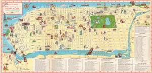
Illustrated Map of the City of New York.
sold
- Digital Map Information
- Suitable for large format printing
- File Size: 28.76 MB
- File Type: ZIP / TIFF
- ICC color profile embedded
- Delivered instantly via download link
Providing a charming and entertaining visual summary of Manhattan's numerous museums, sites, and hotels, this 1956 Ira Ross pictorial map of Manhattan in New York City creates a perfect introduction to the 'Big Apple' for visiting tourists. The map depicts the borough in detail from Battery Park to the Met Cloisters and the Bronx and from the Hudson River to Brooklyn and Queens. Manhattan's famous street grid, with its parallel streets and avenues, is clearly labeled and easily navigated.
The city's most recognizable destinations, including the Metropolitan Museum of Art, the American Museum of Natural History, the Whitney Museum of Modern Art, and the Museum of Modern Art are all marked by vignettes highlighting their most well-known attributes: ancient sculpture, a Tyrannosaurus Rex, and modernist paintings. Other landmarks, such as the Chrysler Building, the Empire State Building, the Flatiron Building, the United Nations Headquarters, and the Washington Arch are illustrated in profile. Numerous hotels are highlighted, as are New York City mainstays like Macy's at Herald Square, Madison Square Garden, and even Yankee Stadium.
Other sites are more comically represented, such as a reading lion for the New York Public Library, a patient chasing a nurse at Bellevue Hospital, or caricatures of opera singers for the Metropolitan Opera House. A now lost part of New York City's, and America's popular culture, the automat, a fast food restaurant where foods and drinks were served out of vending machines is present throughout, with numerous automats marked by blue stars. The city's bridges, including the iconic Brooklyn Bridge, are sketched in profile as well. The city's numerous parks, such as Riverside Park, Fort Tryon Park, and, of course Central Park, stand out as green oases in a desert of yellow. The Statue of Liberty and Ellis Island are included along the left border in New York Harbor. (more details)
The city's most recognizable destinations, including the Metropolitan Museum of Art, the American Museum of Natural History, the Whitney Museum of Modern Art, and the Museum of Modern Art are all marked by vignettes highlighting their most well-known attributes: ancient sculpture, a Tyrannosaurus Rex, and modernist paintings. Other landmarks, such as the Chrysler Building, the Empire State Building, the Flatiron Building, the United Nations Headquarters, and the Washington Arch are illustrated in profile. Numerous hotels are highlighted, as are New York City mainstays like Macy's at Herald Square, Madison Square Garden, and even Yankee Stadium.
Other sites are more comically represented, such as a reading lion for the New York Public Library, a patient chasing a nurse at Bellevue Hospital, or caricatures of opera singers for the Metropolitan Opera House. A now lost part of New York City's, and America's popular culture, the automat, a fast food restaurant where foods and drinks were served out of vending machines is present throughout, with numerous automats marked by blue stars. The city's bridges, including the iconic Brooklyn Bridge, are sketched in profile as well. The city's numerous parks, such as Riverside Park, Fort Tryon Park, and, of course Central Park, stand out as green oases in a desert of yellow. The Statue of Liberty and Ellis Island are included along the left border in New York Harbor. (more details)
Brightly colored and highly detailed pictorial map of mammals and birds native to the United States.
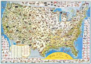
Pictorial Wildlife and Game Map of the United States.
sold
- Digital Map Information
- Suitable for large format printing
- File Size: 18.48 MB
- File Type: ZIP / TIFF
- ICC color profile embedded
- Delivered instantly via download link
This is a 1956 Ira Moss pictorial map of wildlife and game native to the United States. The map depicts the region from Canada to Mexico and from the Pacific Ocean to the Atlantic Ocean. Bright, colorful, and highly detailed, fifty-five different mammal species and ... (more details)
Brightly colored and highly detailed pictorial map of mammals and birds native to the United States.
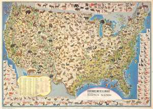
Sportsman's Map of U.S. Wildlife.
sold
- Digital Map Information
- Suitable for large format printing
- File Size: 83.71 MB
- File Type: ZIP / TIFF
- ICC color profile embedded
- Delivered instantly via download link
This is a 1956 Ira Moss pictorial map of wildlife and game native to the United States. The map depicts the region from Canada to Mexico and from the Pacific Ocean to the Atlantic Ocean. Bright, colorful, and highly detailed, fifty-five different mammal species and ... (more details)
Sportsman's Map of U.S. Wildlife.
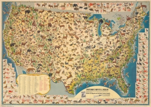
An impressive 1956 Ira Moss pictorial map of wildlife and game native to the United States, sponsored by Outdoor Life magazine and the Marlin Firearms Company. It depicts the richness and variety of fauna in the continental U.S. in fantastic detail. (more details)
The city's iconic landmarks - and it's now closed automats!
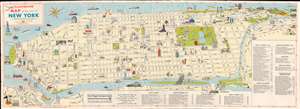
A charming visual summary of Manhattan's museums, sites, and hotels, this 1957 Ira Ross pictorial map of Manhattan in New York City introduces the 'Big Apple' to visitors. Orientd to the west, the map cover Manhattan form Battery Park to the Cloisters, and from the Hudson to Brooklyn and Queens. (more details)