
Moulder, Richard Bruce (sold)

Richard Bruce Moulder (1907 - May 5, 1966) was a British architectural designer born in British Guiana. Very little is definitively known about Moulder, but our research indicates that he spent most of his life on Barbados. He married Mary Gwendoline Pitcher in 1933, with whom he had two children, at least one of them a daughter. He died in Barbados in 1966.
Caribbean paradise!
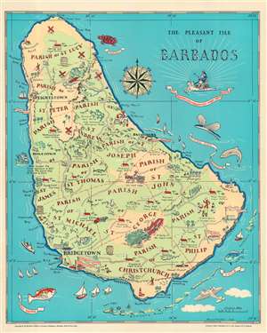
The Pleasant Isle of Barbados.
sold
- Digital Map Information
- Suitable for large format printing
- File Size: 17.23 MB
- File Type: ZIP / TIFF
- ICC color profile embedded
- Delivered instantly via download link
This is a 1946 Bruce Moulder pictorial map of Barbados. Pictorial icons illustrate the island's sugar factories, windmills, and lighthouses. Other illustrations mark hotels, important buildings (such as the Government House in Bridgetown), and the Seawell Airport. A handful of short descriptions provide historical information. Beaches where swimming is possible are noted with the word 'seabathing'. Red dotted and dashed lines separate the island's parishes, each of which is labeled. The Caribbean's diverse sea life encircles the map, with a hawksbill turtle, a flying fish, and a red snapper illustrated. (more details)
Detailed road map of Barbados.
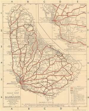
This is a 1956 Margaret Anderson and R. Bruce Moulder road map of Barbados. Red lines highlight major highways, while red and black dashed lines follow secondary highways. Distances along the major highways are marked by small numbers near the route. Roads marked by two thin black parallel lines are 'other roads' per the key situated in the lower right corner. Symbols mark churches, lighthouses, police stations, and gas stations around the island. Cities, towns, and other settlements are identified, along with coastal locations and various other inland locations. An inset of Bridgetown and its environs is situated in the upper right. Here, Anderson and Moulder identify parks, a playing field, cemeteries, schools, and churches. (more details)