
Muller, Julius (sold)

Julius Muller (March 20, 1875 - December 12, 1948) was a Jewish German-American businessman, draftsman, surveyor, and civil engineer. Muller was born in Altonkunstad, Germany but by 1889, at roughly 14, he had emigrated to the United States. It is unclear where in the United States he lived until about 1897, when his is documented in Leadville, Colorado. He was naturalized a U.S. Citizen on year later in 1898. In 1899, he became a clerk for the Jewish Clothier Freedheim Brothers. In 1900 he became a clerk for Baer Brothers Mercantile, a Jewish cigar and liquor merchant. He remained with Baer Bothers until about 1910, when he succeeded into the ownership of said firm, renamed Muller Co. He became quite successful seller beer and spirits and even joined the 'Gentleman Driving Club', competing in several races. When Leadville turned into a dry town, well before national Prohibition, Muller relocated to Denver, and by 1919, to Casper, Wyoming. In Wyoming he worked as. A Civil Engineer, although it is unclear where he received he straining. He remained as a Civili Engineer in Wyoming until his retirement in the mid 1930s. He was employed with the Wyoming highway department and public survey office, and lived the remainder of his life in Casper and Cheyenne. In 1932 he produced the first official highway map of the State of Wyoming. Muller is also the author of The ABC of American Defense, and was known as an expert marksman and talented clarinetist. He died in Cheyenne, Wyoming and was survived bu a daughter. Mildred H. Eakin.
Scarce Example of the First Official Highway Map of Wyoming, Signed by the Author
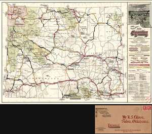
1932 Highway Map of the State of Wyoming.
sold
- Digital Map Information
- Suitable for large format printing
- Full resolution TIFF file
- ICC color profile embedded
- Delivered instantly via download link
A superb example of the first official highway map of Wyoming, signed by the mapmaker, Julius Muller and printed in 1932. The map's title is surmounted with a decorative view of the Grand Tetons and Jackson Lake. The map shows the network of roads, differentiating between those in the State Highway System and those not maintained by the state. Color is used to distinguish oiled or paved roads, gravel roads, graded dirt roads and 'unimproved' dirt roads. Among the roads not maintained by the state, shading and thickness indicates roads that invite 'local inquiry regarding condition' and on which 'chains are advisable during wet weather.' A truly modern map, it includes air routes, and shows landing fields, airports and navigational beacons. Where roads lead the reader off the map, attractively-framed text indicates the prime destinations via that specific route (eg., 'To Rocky Man Nat'l Park or DENVER via Fort Collins and Loveland.') (more details)