
Noll, Edward. P. (sold)

Edward P. Noll (fl. 1882 - 1918) was an American map publisher and map mounter based in Philadelphia during the late 19th and early 20th centuries, trading as E. P. Noll and Company. His firm's publications included county landownership maps, real-estate atlases, urban street guides, and road maps for cyclists and motorists. The business was publishing by 1882, when it issued a landownership map of Floyd County, Indiana, demonstrating that its geographical interests extended beyond Pennsylvania. In Philadelphia, the firm described itself as map publishers and mounters and maintained premises at 17 North Sixth Street, an address appearing on its 1890 city guide map and its Atlas of Bucks Co., Penna of 1891. Its Philadelphia guide maps combined detailed street mapping with ward boundaries and other urban information. Noll also published folding maps of Philadelphia and the surrounding countryside for road travel, including maps expressly intended for bicyclists. By the early 20th century, the firm's road-map titles incorporated automobile travel, while its urban guide-map publishing continued with editions covering Philadelphia and Camden, New Jersey. A 1918 edition of the Philadelphia and Camden guide map documents the continued use of the E. P. Noll and Company imprint.
A Large, Superbly Detailed Map of Western Washington by its Premier Civil Engineer
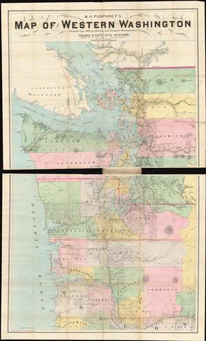
W.H. Pumphrey's map of western Washington: compiled from official records and personal reconnaissance.
sold
- Digital Map Information
- Suitable for large format printing
- File Size: 52.72 MB
- File Type: ZIP / TIFF
- ICC color profile embedded
- Delivered instantly via download link
This rare, detailed map is W. H. Pumphrey's 1892 Map of Western Washington: Compiled from Official Records and Personal Reconnaissance. Pumphrey, a respected Seattle fixture and proprietor of one of its finest stationers, sold the map: it was printed by the powerhouse Philadelphia map publisher Edward Noll and drawn by the Norwegian/ American draftsman F. M. Dehly. (more details)
Hop on your bike and explore the world around you!
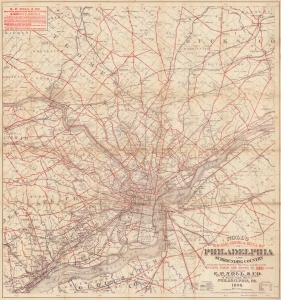
Noll's New Road, Driving and Bicycle Map of Philadelphia and Surrounding Country.
sold
- Digital Map Information
- Suitable for large format printing
- Full resolution TIFF file
- ICC color profile embedded
- Delivered instantly via download link
This is a visually compelling 1896 E.P. Noll and Company map of Philadelphia and environs. The map was published to capitalize on the late-19th-century Philadelphia cycling craze at its apex. Philadelphia's relatively level terrain made it ideal for cycling, and maps like this opened the region to velocipedic exploration. It addressed a practical obstacle to recreational touring: finding usable routes through a road system of uneven quality. Noll combined this route selection with detailed local geography, allowing riders to plan excursions through a landscape of suburban villages, country hotels, mills, and railway stations. (more details)