
Peiyang Press (sold) (北洋印字館)

Peiyang Press (北洋印字館; fl. c. 1925 – 1949) was a publisher active in Tianjin and Beijing (Beiping or Peiping at the time) before and during World War II (1939 - 1945). The press focused on books and maps for the Western traveler in China, including works in English, German, and Dutch. The company's logo included portraits of Gutenberg and Senefelder (who invented lithography). While its owners were likely Western, the staff was multinational; a 1925 directory notes a likely German manager surnamed Kleeman with both German (Niedernhofer, Kirn) and Chinese (Wang, Chi) names among the employees. Among their publications were British authors Alice Leighton Cleather and Basil Crump’s English-language book Buddhism: The Science of Life (2nd ed., 1928), Robert M. Duncan’s Peiping Municipality and the Diplomatic Quarter (1933), a Chinese-Dutch dictionary (1935) and a 1937 album of black and white photographs of British military exercises in China. They also issued a detailed city plan, Map of Tientsin, with editions published in at least 1928 and 1941. They are known to have published at least two influential pictorial maps in English during the 1930s, Frank Dorn's iconic A Map and History of Peiping and John Kirk Sewall's A Pictorial Map of Peiping.
AKA: 北洋印字館
One of the two great Pre-WWII pictorial maps of Beijing.
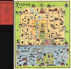
A Pictorial Map of Peiping in full colours.
sold
- Digital Map Information
- Suitable for large format printing
- Full resolution TIFF file
- ICC color profile embedded
- Delivered instantly via download link
This is John Kirk Sewall's rare c. 1928-1933 pictorial map of Beijing or Peking, China. This is one of two great pictorial maps of Beijing issued prior to World War II, the other being by Frank Dorn. The map uses color coding to divide Beijing into three sections, ... (more details)
Foreign concessions and 'special areas'.
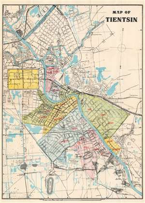
Map of Tientsin.
sold
- Digital Map Information
- Suitable for large format printing
- Full resolution TIFF file
- ICC color profile embedded
- Delivered instantly via download link
This is a 1928 Peiyang Press city plan or map of Tientsin (天津市,Tianjin), China, shortly after the outbreak of the Chinese Civil War (1927 - 1849). Red overprinting identifies the British, French, Italian, Japanese, and Belgian concessions, along with the First, Second, and Third Special Districts. The same red overprinting marks 185 locations corresponding to an index. The Russian Consulate, French Consulate, British Consulate, Italian Consulate, Japanese Consulate, and U.S. Consulate are labeled within the Concessions and Special Areas. Other identified sites include Standard Oil's installation along the Hai Ho River, the Japanese Barracks, several gardens and parks, and Woodrow Wilson Field. (more details)
Iconic map from the golden age of Pictorial Maps.
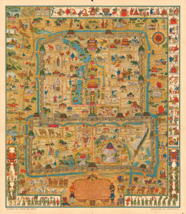
A Map and History of Peiping; formerly known as Peking; capital of provinces, princedoms, and kingdoms since 1121 B.C.; in 1264 A.D. the capital of the Mongol Empire of Kublai Khan; made the capital of the Ming Empire and built as it is today by Yung Lo in 1421; continued as the capital of the Chinese Empire through the Ming and Ching Dynasties; and now a city which will live long in the memory of man as one of the greatest the world has ever known. Completed on this fifth day of February in the year of our Lord Nineteen Hundred and Thirty-six.
sold
- Digital Map Information
- Suitable for large format printing
- Full resolution TIFF file
- ICC color profile embedded
- Delivered instantly via download link
An example of Frank Dorn's iconic 1936 chromolithograph pictorial map of Beijing or Peking, China. It is considered one of the great maps from the Golden Age of Pictorial Cartography. The map captures Beijing in the days leading up to World War II (1939 - 1945) - though by this time, China was already at odds with Japan, and the Second Sino-Japanese War (1937 - 1945), a precursor to WWII in Asia, was brewing. (more details)
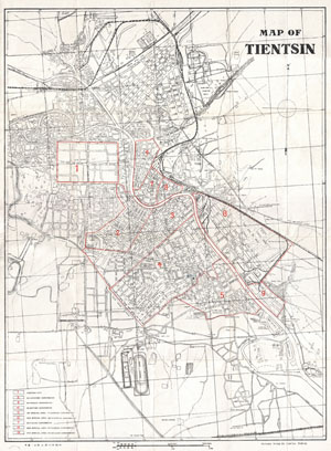
Map of Tientsin.
sold
- Digital Map Information
- Suitable for large format printing
- File Size: 5.14 MB
- File Type: ZIP / TIFF
- ICC color profile embedded
- Delivered instantly via download link
This rare and unusual map depicts the city of Tientsin, the second most important city, following Beijing, in Northern China. Map is entirely in English and comes with a booklet that discusses the various concessions: Japanese, French, British, ... (more details)