
Pico, Pedro (sold)

Pedro Pico (1810 - 1886) was an Argentine surveyor. Born in Buenos Aires, he was educated as an engineer in England. Returning to America, he became a surveyor for Uruguay. By 1837, he was employed in that capacity by the Department of Mines; some manuscripts of his have survived from that period. With the advent of the Uruguayan Civil War, he moved to Montevideo and joined the forces holding the city against Rosas. He produced a plan of the city in 1845 during the course of the siege, marking the positions of the opposing forces. In its first edition, it is one of the earliest maps printed in Uruguay. Following the war, Pico returned home to Buenos Aires where he taught classes at the University and joined the Topographic Department. He also produced geographical map of the province of Entre Ríos, during the period in which it was governed by General Urquiza. He retired to Rivadavia in Argentina, and died in 1886.
Printed in Montevideo while under siege!
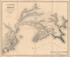
Plano Topográfico de la ciudad y cercanias de Montevideo.
sold
- Digital Map Information
- Suitable for large format printing
- DPI: 600
- File Size: 43.87 MB
- File Type: ZIP / TIFF
- ICC color profile embedded
- Delivered instantly via download link
This is an elegant and rare 1846 Pedro Pico map of Montevideo, Uruguay. It was published in Montevideo during the Great Siege of Montevideo during the Uruguayan Civil War (1839 - 1851). (more details)
Theater of the War of the Triple Alliance.
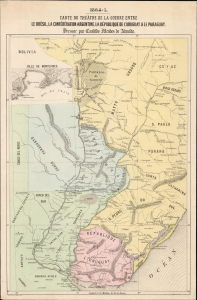
Carte du Théâtre de la Guerre Entre Le Brésil, La Confédération Argentine, La République de l'Uruguay et Le Paraguay Dressée par Candido Mendes de Almeida.
sold
- Digital Map Information
- Suitable for large format printing
- File Size: 5.51 MB
- File Type: ZIP / TIFF
- ICC color profile embedded
- Delivered instantly via download link
This is a rare 1869 map of the theater of the Paraguayan War, or the War of the Triple Alliance, drafted by Brazilian statesman and historian Candido Mendes de Almeida in the first years of the war. Its geography reflects the situation in 1865, when an increasingly militaristic and aggressive Paraguay, under the disastrous reign of Francisco Solano López Carrillo (1827 - 1870), inspired the unlikely alliance of traditional enemies, Brazil, Uruguay, and the Argentine Republic. The war, a year old when this map was composed, would by 1870 result in Paraguay's virtual annihilation. This Paris edition of the map was printed as a supplement to the 1869 Revue Martime et Coloniale, published by the French Ministere de la Marine et des Colonies. France had, from the dawn of Uruguay's independence, maintained a political and trade interest there, and so the turmoil of the Plata region during the 1860s would have been of pressing interest. (more details)