
Pontault de Beaulieu, Sébastien (sold)

Sébastien Pontault de Beaulieu (1612 - 1674) was a French engineer who is considered to be the first military topographer. Active during the reigns of Louis XII and Louis XIV, Pontault de Beaulieu is more accurately considered to be the creator of military topography and is best known for systematic plans of battles, sieges, military expeditions, and other affairs dealing with the army during this time period. He joined the army at fifteen during the siege of La Rochelle (1627 - 1628) and also saw combat at the siege of Arras, the siege of Perpignan, and the siege of Dunkirk, among others. His major work is entitled Les glorieuses conquêtes de Louis le Grand or Recueil de plans et sues de places assiégés, et de celles où se sont données des bataiiles, avec des discours
Unique First State.
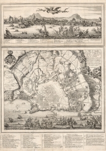
Candie/ La Ville de Candie pour la 3e. sois attaquee de L'armée Ottomane, et deffendue par Celle de la Serenissime Rep: de Venise... 1667, 68 et 69.
sold
- Digital Map Information
- Suitable for large format printing
- DPI: 600
- File Size: 109.01 MB
- File Type: ZIP / TIFF
- ICC color profile embedded
- Delivered instantly via download link
This is an extremely rare, likely unique, separately published 1668 broadsheet plan of the port of Heraklion / Candia, Crete, incorporating a striking panoramic view of the city. This broadsheet illustrates Venetian-controlled Heraklion during the final years of its 21-year-long Ottoman siege. It was privately commissioned and engraved to lionize the efforts of French nobleman Alphonse-Louis, Chevalier d’Harcourt, who perceived himself not only a defender of Crete, but as a latter-day crusader defending Christianity itself. (more details)
Created after the Ottomans conquered Crete, removing it from Venice's overseas empire.
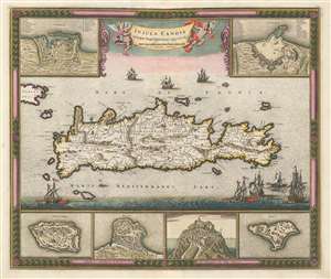
Insula Candia Ejusque Fortificatio.
sold
- Digital Map Information
- Suitable for large format printing
- DPI: 600
- File Size: 29.76 MB
- File Type: ZIP / TIFF
- ICC color profile embedded
- Delivered instantly via download link
This is a c. 1680 Frederik de Wit map of Crete only years after the end of the Cretan War, which is also known as the Fifth Ottoman-Venetian War. Based on a map created by Sébastien Pontault de Beaulieu, the map depicts the entire island after the end of the Siege of Candia, a 24-year long siege of a fortress on Crete. Candia, along with myriad other cities, towns, and villages are labeled all across Crete, and roads, rivers, and mountain ranges are also illustrated. Six inset maps are placed along the borders that focus on Crete's fortresses at Canea, Candia, Spina Longa, Retimo, Thine, and Suda, a natural inclusion since Pontault de Beaulieu is known for his work illustrating Mediterranean fortifications. (more details)