
Rand, Edward Lothrop (sold)

Edward Lothrop Rand (August 22, 1859 - October 9, 1924) was an American botanist, lawyer, and cartographer. Born in Dedham, Massachusetts, Rand was born Edward Sprague Rand IV but later changed his name to Edward Lothrop Rand on July 2, 1878, following a scandal involving his father over-mortgaging the family home, evading arrest, and fleeing to Brazil. He attended Harvard University and graduated in 1881 and graduated from Harvard Law School in 1884 and went on to practice law in Boston, but his true passion in life was botany. Rand was famous on Mount Desert Island as one of the members of the Champlain Society and as the first Chairman of the Path Committee on Mount Desert Island. He co-author Flora of Mount Desert Island, Maine with J.H. Redfield and created map of Mount Desert Island with Waldron Bates and Herbert Jaques. Rand married Annie Matilda Crozier on June 29, 1893 in Boston.
The last edition of a landmark map in the cartography of Mount Desert Island.
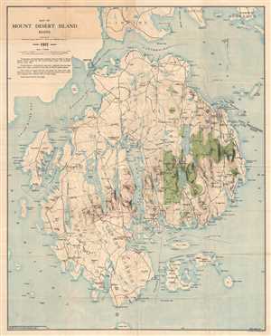
Map of Mount Desert Island Maine.
sold
- Digital Map Information
- Suitable for large format printing
- File Size: 19.96 MB
- File Type: ZIP / TIFF
- ICC color profile embedded
- Delivered instantly via download link
This is a 1911 map of Mount Desert Island, Maine compiled by Waldron Bates, Edward L. Rand, and Herbert Jaques. The map depicts the island from Blue Hill Bay to Frenchman's Bay and from Lamoine, Hancock, and Sorrento to Great Gott Island. Highly detailed, locations throughout the island are labeled, including the towns of Bar Harbor (labeled here as Eden), Mount Desert, Southwest Harbor, and Tremont. Villages throughout each of these towns are also labeled, including Salisbury Cove, Somesville, West Tremont, and Seal Harbor. The topography, illustrating elevation changes in forty-foot intervals, was adapted from the Map of Mount Desert Island issued by the United States Coast and Geodetic Survey in 1882, as was the hydrography.
(more details)
(more details)