
Seibidō (sold) (株式會社精美堂)

Seibidō (株式會社精美堂; fl. c. 1886 - present) is a Tokyo-based printer and publisher. Initially specializing in newspaper illustrations, advertisements, and headline fonts, Seibidō later branched into other areas of publishing and printing. The company was late to switch away from woodblock techniques, not doing so until the postwar period, but then rapidly adopted the latest technology of the 1950s. By the 1970s, the company had stopped publishing their own material but focused instead on platemaking and advertisements, and by the 1990s had embraced digital printing techniques.
AKA: 株式會社精美堂
Japan Makes Hay while Europe Burns.
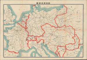
歐洲戰局詳圖 / [Detailed Map of the European War Situation].
sold
- Digital Map Information
- Suitable for large format printing
- DPI: 600
- File Size: 33.77 MB
- File Type: ZIP / TIFF
- ICC color profile embedded
- Delivered instantly via download link
This is a scarce 1914 Japanese-language map of Europe in the opening months of World War I, edited by Hasegawa Seiya for the periodical True Account of the War in Europe. It reflects the significant but often overlooked role that World War I had in catapulting Japan into a global power and setting the stage for World War II. Although little known in the West, Japan was an enthusiastic member of the Entente Alliance during World War I (1914 - 1918), which it leveraged to expand its influence in China and East Asia. (more details)
How a wood and paper city burns.
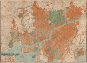
帝都大震火災系統地圖 / Map of the Fire of Tokyo.
sold
- Digital Map Information
- Suitable for large format printing
- File Size: 191.05 MB
- File Type: ZIP / TIFF
- ICC color profile embedded
- Delivered instantly via download link
An infographic masterpiece detailing the ignition and development of the Great Fire of Tokyo following the 1923 Great Kanto Earthquake. This partially bilingual 1923 map of the Great Tokyo Fire was issued by the Relief Information Bureau of Tokyo Imperial University just four months after the disaster. It focuses on ignition points and on the strong winds that coincided with the earthquake, which caused fire to spread rapidly and eventually burn down much of the dense wooden city. (more details)
How a wood and paper city burns.
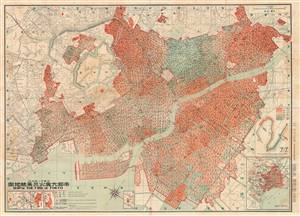
帝都大震火災系統地圖 / Map of the Fire of Tokyo.
sold
- Digital Map Information
- Suitable for large format printing
- File Size: 69.11 MB
- File Type: ZIP / TIFF
- ICC color profile embedded
- Delivered instantly via download link
An astounding infographic masterpiece detailing the ignition and development of the Great Fire of Tokyo following the 1923 Great Kanto Earthquake. This is a partially bilingual 1923 map of Great Tokyo Fire was issued by the Bureau of Tokyo Imperial University just four months after the disaster. It focuses ignition points and on the strong winds that coincided with the earthquake, which caused fire to spread rapidly and eventually burn down much of the city - which was constructed of tightly packed wooden buildings. (more details)
How a wood and paper city burns.
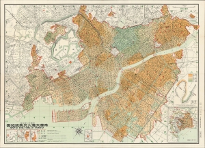
帝都大震火災系統地圖 / Map of the Fire of Tokyo.
sold
- Digital Map Information
- Suitable for large format printing
- File Size: 70.51 MB
- File Type: ZIP / TIFF
- ICC color profile embedded
- Delivered instantly via download link
An infographic masterpiece detailing the ignition and development of the Great Fire of Tokyo following the 1923 Great Kanto Earthquake. This partially bilingual 1923 map of the Great Tokyo Fire was issued by the Relief Information Bureau of Tokyo Imperial University just four months after the disaster. It focuses on ignition points and on the strong winds that coincided with the earthquake, which caused fire to spread rapidly and eventually burn down much of the dense wooden city. (more details)