
Selchow, Roger Hoffman (sold)

Roger Hoffman Selchow (February 13, 1911 - 1995) was an American artist. Born in Greenwich, Connecticut, Selchow is best known for his paintings of geometric abstractions. Selchow studied at Columbia University. His work is part in the collections of the Metropolitan Museum of Art in New York City, the Brooklyn Museum in Brooklyn, the Wadsworth Atheneum in Hartford, Connecticut, and the Musée des Beaux-Arts in Liège, Belgium, among others.
A pictorial map of Greenwich, Connecticut celebrating the 300th anniversary of its founding.
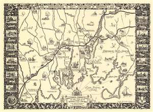
Greenwich, Connecticut at the Time of Ye Revolution 1775 - 1800. 1640 - Commemorating Ye 300th Anniversary of Greenwich - 1940.
sold
- Digital Map Information
- Suitable for large format printing
- File Size: 27.45 MB
- File Type: ZIP / TIFF
- ICC color profile embedded
- Delivered instantly via download link
This is a very rare 1939 Roger Selchow pictorial map of Greenwich, Connecticut created to celebrate the 300th anniversary of Greenwich's founding. Depicting Greenwich from Byram Point to Stamford and from The Fincherie Ezekiel Finch House to Elisabeth's Neck and Long Island Sound, Selchow captures the area may have been during the era of the American Revolution. Homesteads, taverns, and mills are identified, labeled, and even dated. Stars identify historic buildings that survived to 1939, when the map was published. The Indian village where a 1644 massacre perpetrated by Dutch colonists, part of Kieft's War, is noted. Soo too is the site on Elizabeth's Neck where Captain Daniel Patrick and Robert Feaks landed on July 18, 1640. (more details)
Extremely rare Greenwich, Connecticut pictorial.
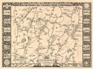
Northern Greenwich in Connecticut in Ye Olden Days before 1875.
sold
- Digital Map Information
- Suitable for large format printing
- File Size: 61.05 MB
- File Type: ZIP / TIFF
- ICC color profile embedded
- Delivered instantly via download link
A rare pictorial map of the northern part of Greenwich, Connecticut issued in 1948 by Roger H. Selchow. This is a companion piece to an earlier 1939 map of coastal Greenwich issued by the same artist. Coverage extends roughly from what is today Route 1 north to the New York border, and from Rye to Stamford, including the communities of Round Hill, Riversville, Stanwich, North Greenwich, and South Stanwich. (more details)