
Symonds, Henry Delahoy (sold)

Henry Delahoy Symonds (fl. 1791 - 1816) was a British publisher / printer. He was an active and considerable bookseller for many years in Paternoster Row. As stated in an obituary, 'in the commencement of the crusade against the French Revolution, he suffered four years imprisonment in Newgate, and paid a heavy fine for vending some political pamphlets.'
Important post-Revolutionary War map of New England!
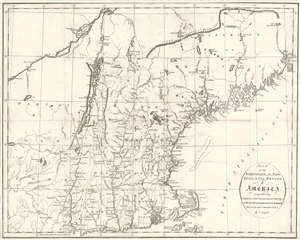
Map of the Northern, or, New England States of America, Comprehending Vermont, New Hampshire, District of Main, Massachusetts, Rhode Island, and Connecticut.
sold
- Digital Map Information
- Suitable for large format printing
- DPI: 600
- File Size: 11.76 MB
- File Type: ZIP / TIFF
- ICC color profile embedded
- Delivered instantly via download link
An attractive and finely engraved 1795 map of New England by John Russell - one of the few commercial maps of New England issued immediately following the American Revolutionary War (1775 - 1783). The map covers the northwestern part of the United States from, roughly, Lake Oneida (near Fort Stanwix) to Passamaquoddy Bay, New Brunswick, and from Montreal south as far as Tappan Zee, Martha's Vineyard, and Nantucket. This includes the District of Maine (which was then under the governance of Massachusetts), Vermont, New Hampshire, Massachusetts, Connecticut, and Eastern New York. (more details)
Labels several different land companies that played an important role in American expansion into the Northwest Ordinance.
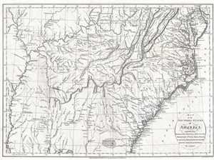
Map of the Southern States of America, Comprehending Maryland, Virginia, Kentucky, Territory South of the Ohio, North Carolina, Tennessee Government, South Carolina, and Georgia.
sold
- Digital Map Information
- Suitable for large format printing
- DPI: 300
- File Size: 6.89 MB
- File Type: ZIP / TIFF
- ICC color profile embedded
- Delivered instantly via download link
This is a 1795 John Russell map of the southeastern United States. The map depicts the region from the Mississippi River to the Atlantic Ocean and from Wilmington, Delaware to Mobile and Mobile Bay, Alabama and Pensacola, Florida. Expansion of the United States In ... (more details)