
Transcontinental Cartographers Limited (sold)

Transcontinental Cartographers Limited (fl. c. 1971 - 1972) was a publishing company based in Vancouver, British Columbia. The company published several pictorial maps of American and Canadian cities, including Boston, San Francisco, New Orleans, Kansas City, Atlanta, Minneapolis, and Vancouver. It appears that they subscribed to the ‘subscription model’ of cartography, by accepting payment from companies to feature their businesses in their maps. Their maps were distributed by A.A. Sales Inc. of Seattle, Washington.
Home of the Indianapolis 500 occupies the bottom border of the map - with incredible illustrations of racecars!
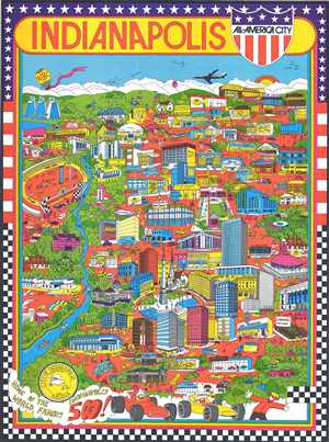
Indianapolis. All-America City.
sold
- Digital Map Information
- Suitable for large format printing
- File Size: 28.62 MB
- File Type: ZIP / TIFF
- ICC color profile embedded
- Delivered instantly via download link
This is a 1971 Trans Continental Cartography pictorial map of Indianapolis, Indiana. The map depicts the city of Indianapolis in a nonconventional manner, creating a map that is meant more for decoration than for practical use. Several Indianapolis landmarks are ... (more details)
Racecars!
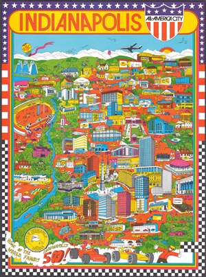
This is a 1971 Trans Continental Cartography pictorial map of Indianapolis, Indiana. The map depicts the city of Indianapolis in a nonconventional manner, leading to a highly decorative piece. Various Indianapolis landmarks are illustrated, including the Indianapolis Motor Speedway, the Indiana World War Memorial, the Indiana State Soldiers and Sailors Memorial, the Indiana State Capital building, the Indianapolis Zoo, and the Indiana State Fairgrounds Coliseum – home of the Indiana Pacers in 1971. Various other businesses, shops, hotels, banks, and WIBC radio station are also included. (more details)
Highly attractive - and humorous! - map of Atlanta, Georgia bordered by columns and peach blossoms.
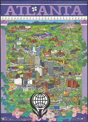
Atlanta.
sold
- Digital Map Information
- Suitable for large format printing
- File Size: 48.03 MB
- File Type: ZIP / TIFF
- ICC color profile embedded
- Delivered instantly via download link
This is an extremely rare and creative 1972 Trans Continental Cartographers pictorial map of Atlanta. The map depicts the city of Atlanta in a nonconventional manner, creating a map that is meant more for decoration than for practical use. Several famous Atlanta ... (more details)
An extremely rare and highly entertaining pictorial map of New Orleans, Louisiana during Mardi Gras.
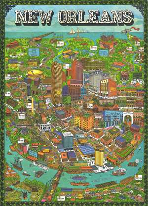
New Orleans.
sold
- Digital Map Information
- Suitable for large format printing
- File Size: 32.23 MB
- File Type: ZIP / TIFF
- ICC color profile embedded
- Delivered instantly via download link
This is an extremely rare and creative 1972 Trans Continental Cartographers pictorial map of New Orleans, Louisiana. The map depicts the center of New Orleans, from the Mississippi River, labeled here as 'The Mighty Mississippi' to the shores of Lake ... (more details)
Entertaining pictorial map of New Orleans during Mardi Gras.
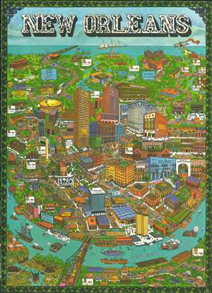
This is an uncommon and creative 1972 Trans Continental Cartographers pictorial map of New Orleans, Louisiana. The map depicts the center of modern New Orleans, from the Mississippi River (labeled here as 'The Mighty Mississippi') to the shores of Lake Pontchartrain during Mardi Gras. A depiction of the famous Mardi Gras parade features prominently, with floats, performers in costume, and a pink elephant all taking part. Other mentions of Mardi Gras include a banner pulled by a biplane in the upper right corner and a depiction of the Mardi Gras fountain on the shore of Lake Pontchartrain. The map also includes depictions of several well-known New Orleans landmarks, such as Tulane University, the Sugar Bowl, the Superdome, and the French Quarter or Vieux Carre. It depicts the Lake Pontchartrain Causeway, which was opened in 1969, and is the longest continuous bridge over water in the world at 23.83 miles. (more details)