
Treskot, Ivan Fomic (sold) (Иван Фомич Трускотт)

Ivan (Johann) Fomic Treskot (Иван Фомич Трускотт; December 1, 1721 - May 18, 1786), also spelled Treskott, Truscott, or Truskot, was a Russian cartographer active in St. Petersburg in the late 18th century. Treskot was born in St. Peterburg, the son of an English merchant (perhaps the reason his name is sometimes recorded as John Truskott). He studied architecture and cartography at the Russian Academy of Sciences under Joseph-Nicolas De l'isle (April 4, 1688 – September 11, 1768) and Jacob Friedrich Schmidt (Якоб Фридрих Шмидт; 1723 - 1786). In 1746 he was made head of the Cartographic Department at the St. Petersburg Academy of Sciences. They went on to compile a detailed mapping of Siberia, publishing various regional maps from 1770 to 1776. Working with Schmidt, Treskot compiled the 1784 Tabula Geographica Generalis Imperii Russici, the finest general map of the empire since after the 1734 Kirilov. Treskot was active at the Russian Academy's Geographical Department for nearly 50 years, from 1737 to his death in 1786. While he supervised the construction of hundreds of maps, only 11 of which bear his imprint.
AKA: Иван Фомич Трускотт
One of the first specific Russian maps of eastern Siberia.
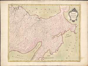
Territorii Jakutensis pars orientalis.
sold
- Digital Map Information
- Suitable for large format printing
- Full resolution TIFF file
- ICC color profile embedded
- Delivered instantly via download link
An exceptional separately issued 1771 Ivan Fomic Treskot map of Siberia, part of the Treskot-Schmidt effort to map Siberia between 1770 and 1776. This map represents one of the earliest specific published maps of northeastern Siberia. Coverage extends from the Kolyma River to the Bearing Strait and from the bulbous Tschtuki Peninsula to Penzhin Bay and Shielikhov Gulf (northern Sea of Okhotsk), and northern Kamchatka. The map is a composite of the finest cartographic knowledge then available to the Russian Academy at St. Petersburg. The treatment of the complex inland river systems in particular represents a major step forward in regional cartography. (more details)