
U.S. Department of State (sold)

U.S. Department of State (1789 - present) is the main foreign affairs body of the executive branch of the United States government. It has produced thousands of maps since the start of the 20th century dealing with U.S. geography, the geography of foreign countries, and the location of embassies and consulates.
Cowboys and Cold War propaganda.
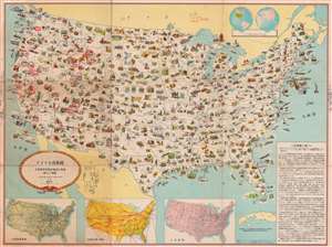
アメリカ合衆國 主要地方資源產物及び風景絵入り地図 / [Pictorial Map of the United States of America Showing Principal Regional Resources, Products and Natural Features].
sold
- Digital Map Information
- Suitable for large format printing
- File Size: 129.51 MB
- File Type: ZIP / TIFF
- ICC color profile embedded
- Delivered instantly via download link
This is a c. 1954 Japanese language pictorial map of the United States published by the U.S. Department of State and distributed by the U.S. Information Agency (U.S.I.A.). It was likely intended both for Japanese travelers to the United States and for consumption within Japan to increase knowledge about the U.S. Although outwardly rather innocuous, it was a product of a wider Cold War information war meant to improve the perception of the U.S. in foreign countries. (more details)