
Vance, David H. (sold)

David H. Vance (1799 - c. May 29, 1832) was an American mapmaker, surveyor, and engraver based in New York and Philadelphia. Vance is an important if elusive figure. He appears in a ship passenger manifest form 1824 returning from England, where he is identified as a Land Agent and Surveyor. He drafted many of the maps for Anthony Finley's New American Atlas, and engraved several maps for Harty's Modern Atlas. In 1825 - 26 Vance compiled an important large-scale wall map of the United States and a map of the world, both also in partnership with Anthony Finley. In 1825, along with J. Ogden Dey, he completed a seminal map of western New York state.
First map to show U.S. claims to British Columbia.
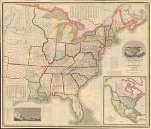
Map of the United States of North America Compiled from the Latest and most Authentic Information by David H. Vance.
sold
- Digital Map Information
- Suitable for large format printing
- DPI: 600
- File Size: 277.94 MB
- File Type: ZIP / TIFF
- ICC color profile embedded
- Delivered instantly via download link
This is the first edition of David Vance and Anthony Finley's outstanding wall map of the United States, published in 1825, here in a remarkable fresh state. This map is significant with regard to its early date, contemporaneous with Amos Lay's map, but more ambitions and predating the 1829 Tanner map by 4 years, as well as its detailed coverage of historic developments. Converge encompasses the Untitled States as it appeared at the time, extending from roughly the Texas Border (100° West of Greenwich / 27° West of Washington) to the Pacific and from the Saint Lawrence River to the Florida Keys. A large inset map appears in the lower right quadrant, illustrating the whole of North America. This is the first map to illustrate American claims to British Columbia that would later spark the 54°40' Debate. (more details)
Settling the great northern wilderness.
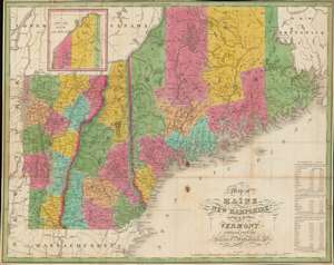
Map of Maine, New Hampshire and Vermont, Compiled From The Latest Authorities.
sold
- Digital Map Information
- Suitable for large format printing
- Full resolution TIFF file
- ICC color profile embedded
- Delivered instantly via download link
This is an attractive 1826 folding map of Maine, New Hampshire, and Vermont produced by Anthony Finley, James H. Young, and David H. Vance. Though originally engraved for Finley's A New American Atlas, this is a rare separate issue. It portrays northern New England as the region was undergoing a population boom in the decades after independence. (more details)