
Vaughan, Henry Goodman (sold)

Henry Goodman Vaughan (September 28, 1868 - November 22, 1938) was an American lawyer and avid huntsman. Born in Cambridge, Massachusetts, to Benjamin and Anna Goodwin Vaugnan, Vaughan was educated at Noble School in Boston before attending Harvard, from which he graduated cum laude in 1890. He graduated cum laude from Harvard Law School and Harvard's graduate school three years later with both a law degree and a Master of Arts degree. Vaughan worked for thirty years as the master of foxhounds at the Norfolk Hunt Club and retired in 1933. He helped organize the Masters of Foxhounds Association of America and served for twenty-five years as its secretary-treasurer before serving for a time as its president. Vaughan practiced law in Boston with Arthur Hendricks and died on the train on his way home to South Berwick, Maine from Cambridge after attending the funeral Mr. Hendricks in Cambridge. Vaughnan married Olea Bull in 1894, who died in 1911. Their one daughter died in infancy. He remarried on April 5, 1915 to Elizabeth Russell Tyson of Boston.
Fox Hunting in Eastern Massachusetts!
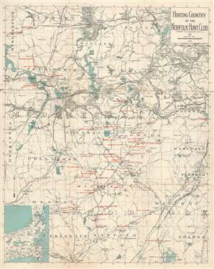
Hunting Country of the Norfolk Hunt Club.
sold
- Digital Map Information
- Suitable for large format printing
- File Size: 19.71 MB
- File Type: ZIP / TIFF
- ICC color profile embedded
- Delivered instantly via download link
This is a 1922 Henry Goodman Vaughan map of Middlesex County, Massachusetts created for the Norfolk Hunt Club, a Massachusetts fox hunting and horseback riding organization. The map depicts the region from Hopkinton to Norwood and from Sudbury to Franklin. Red overprinting labels the Norfolk Hunt Club, along with their kennels. Numerous clubs, railroad stations, farms, and other locations are also labeled, and sadly the details of many of them have been lost to history. On the base map, the region's road and railroad network are detailed, as are its lakes, ponds, and rivers. An inset map of eastern Cape Cod is situated in the lower left corner. (more details)